
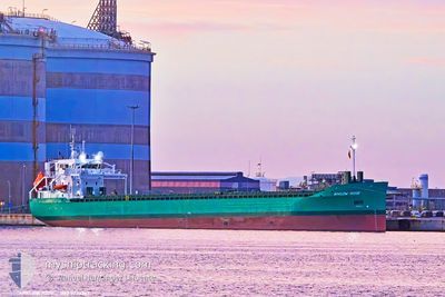
ARKLOW ROSE
Cargo
Current Trip
| Trip Time | 8 days |
|---|---|
| Trip Distance | 936.00 nm |
| AVG Speed | 10.4 Knots |
| MAX Speed | 14.2 Knots |
| Dybgang | 6 m |
| AVG Wind | 12 knots |
| MAX Wind | 22.7 knots |
| MIN Temp | 7.1°C / 44.78°F |
| MAX Temp | 15.3°C / 59.54°F |
| Position Modtaget | 1 m siden |
Current Position
| Longitude | --- |
|---|---|
| Latitude | --- |
| Status | Moored |
| Fart | |
| Kurs | 139° |
| Område | North Atlantic Ocean |
| Station | T-AIS |
| Position Modtaget | 1 m siden |
Info
Information
The current position of ARKLOW ROSE is in North Atlantic Ocean with coordinates 38.50070° / -8.84279° as reported on 2025-03-18 04:06 by AIS to our vessel tracker app. The vessel's current speed is 0 Knots and is currently inside the port of SETUBAL.
The vessel ARKLOW ROSE (IMO: 9923267, MMSI: 250014193) is a Cargo It's sailing under the flag of [IE] Ireland.
In this page you can find informations about the vessels current position, last detected port calls, and current voyage information. If the vessels is not in coverage by AIS you will find the latest position.
The current position of ARKLOW ROSE is detected by our AIS receivers and we are not responsible for the reliability of the data. The last position was recorded while the vessel was in Coverage by the Ais receivers of our vessel tracking app.
The current draught of ARKLOW ROSE as reported by AIS is 6 meters
Weather
| Temperature | 11.8°C / 53.24°F |
|---|---|
| Wind Speed | 4 knots |
| Direction | 318° NW |
| Pressure | 1008 hPa |
| Humidity | 91.1 % |
| Cloud Coverage | 82 % |
Featured Company
Last Port Calls
| Port | Arrival | Departure | Time In Port |
|---|---|---|---|
| 2025-03-16 16:00 | |||
| 2025-03-05 22:20 | 2025-03-08 00:25 | 2 d | |
| 2025-03-01 06:33 | 2025-03-02 11:13 | 1 d | |
| 2025-02-24 20:19 | 2025-02-27 19:56 | 2 d | |
| 2025-02-19 17:54 | 2025-02-20 23:16 | 1 d | |
| 2025-02-17 14:04 | 2025-02-19 17:11 | 2 d | |
| 2025-02-10 06:24 | 2025-02-10 12:00 | 5 h | |
| 2025-02-07 16:29 | |||
| 2025-02-03 11:31 | 2025-02-05 20:03 | 2 d | |
| 2025-01-25 11:08 | 2025-01-28 18:21 | 3 d |
Last Trips
| Origin | Departure | Destination | Arrival | Distance | |
|---|---|---|---|---|---|
| 2025-03-08 00:25 | 2025-03-16 16:00 | 936.00 nm | |||
| 2025-03-02 11:13 | 2025-03-05 22:20 | 63.97 nm | |||
| 2025-02-27 19:56 | 2025-03-01 06:33 | 323.46 nm | |||
| 2025-02-20 23:16 | 2025-02-24 20:19 | 800.39 nm | |||
| 2025-02-19 17:11 | 2025-02-19 17:54 | 6.35 nm | |||
| 2025-02-10 12:00 | 2025-02-17 14:04 | 1828.88 nm | |||
| 2025-02-05 20:03 | 2025-02-07 16:29 | 548.18 nm | |||
| 2025-01-28 18:21 | 2025-02-03 11:31 | 1393.54 nm | |||
| 2025-01-18 20:36 | 2025-01-25 11:08 | 506.92 nm | |||
| 2025-01-03 14:49 | 2025-01-17 06:14 | 1889.38 nm |
Events
| Tid | Hændelsen | Detaljer | Position / Dest | Info |
|---|---|---|---|---|
| 2025-03-16 20:16 | Status er ændret | Moored At anchor |
38.50072 / -8.84276
[PT] SETUBAL
|
Fart: Kurs: 140° |
| 2025-03-16 16:31 | STOP Sejllads |
38.50069 / -8.84278
[PT] SETUBAL
|
Fart: 0.1 kn Kurs: 138° |
|
| 2025-03-16 16:00 | START Sejllads |
38.51607 / -8.88443
[PT] SETUBAL
|
Fart: 6.2 kn Kurs: 63.2° |
|
| 2025-03-16 16:00 | Skibe i havn |
|
38.51607 / -8.88443
[PT] SETUBAL
|
Fart: 5.9 kn Kurs: 58.1° |
| 2025-03-11 20:08 | STOP Sejllads | 1.39 nm, West of SETUBAL |
38.51435 / -8.88533
PTSET
|
Fart: 0.1 kn Kurs: 217° |
| 2025-03-11 20:04 | Status er ændret | At anchor Under way using engine |
38.51442 / -8.88544
PTSET
|
Fart: 0.6 kn Kurs: 208° |
| 2025-03-11 18:42 | ETA er ændret | 2025/03/11 19:00 2025/03/11 17:00 |
38.41090 / -9.05145
PTSET
|
Fart: 4.9 kn Kurs: 74° |
| 2025-03-11 08:07 | Dybgangen er ændret | 6 6.1 |
39.67199 / -10.08566
PTSET
|
Fart: 11.2 kn Kurs: 185.3° |
| 2025-03-11 08:07 | ETA er ændret | 2025/03/11 17:00 2025/03/11 20:00 |
39.67199 / -10.08566
PTSET
|
Fart: 11.2 kn Kurs: 185.3° |
| 2025-03-11 07:10 | Fundet i havområde | Portuguese part of the North Atlantic Ocean |
39.84038 / -10.08018
North Atlantic Ocean
PTSET
|
Fart: 11 kn Kurs: 173.7° |