
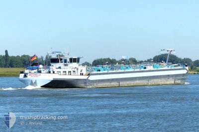
ANTONELA
Other Type
Current Trip
ARA
| Time Travelled | 2 h, 7 mins |
|---|---|
| Remaining Time | --- |
| Distance Travelled | 18.76 nm |
| Remaining Distance | --- |
| AVG Speed | 9.6 Knots |
| MAX Speed | 10.4 Knots |
| AVG Wind | 10.9 knots |
| MAX Wind | 11.9 knots |
| MIN Temp | 7.6°C / 45.68°F |
| MAX Temp | 8.6°C / 47.48°F |
| Dybgang | 2.3 m |
| Position Modtaget | 1 m siden |
Current Position
| Longitude | --- |
|---|---|
| Latitude | --- |
| Status | Moored |
| Fart | 0.9 Knots |
| Kurs | --- |
| Område | North Sea |
| Station | T-AIS |
| Position Modtaget | 1 m siden |
Info
Information
The current position of ANTONELA is in North Sea with coordinates 51.69761° / 4.42366° as reported on 2024-11-26 16:05 by AIS to our vessel tracker app. The vessel's current speed is 0.9 Knots
The vessel ANTONELA (MMSI: 211664870) is a Other Type It's sailing under the flag of [DE] Germany.
In this page you can find informations about the vessels current position, last detected port calls, and current voyage information. If the vessels is not in coverage by AIS you will find the latest position.
The current position of ANTONELA is detected by our AIS receivers and we are not responsible for the reliability of the data. The last position was recorded while the vessel was in Coverage by the Ais receivers of our vessel tracking app.
The current draught of ANTONELA as reported by AIS is 2.3 meters
Weather
| Temperature | 7.3°C / 45.14°F |
|---|---|
| Wind Speed | 7 knots |
| Direction | 226° SW |
| Pressure | 1017.6 hPa |
| Humidity | 88.9 % |
| Cloud Coverage | 63 % |
Featured Company
Last Port Calls
| Port | Arrival | Departure | Time In Port |
|---|---|---|---|
| 2024-11-26 12:23 | 2024-11-26 15:00 | 2 h | |
| 2024-11-25 21:41 | 2024-11-25 21:42 | 1 m | |
| 2024-11-21 19:05 | 2024-11-22 19:54 | 1 d | |
| 2024-11-21 09:35 | 2024-11-21 15:54 | 6 h | |
| 2024-11-18 21:50 | 2024-11-19 07:00 | 9 h | |
| 2024-11-18 08:06 | 2024-11-18 10:03 | 1 h | |
| 2024-11-16 13:14 | 2024-11-16 16:11 | 2 h | |
| 2024-11-15 13:01 | 2024-11-15 13:32 | 31 m | |
| 2024-11-15 10:25 | 2024-11-15 10:38 | 13 m | |
| 2024-11-15 09:08 | 2024-11-15 10:09 | 1 h |
Most Visited Ports (Last year)
| Port | Arrivals | |
|---|---|---|
| 30 | ||
| 19 | ||
| 19 | ||
| 15 | ||
| 11 | ||
| 11 |
Last Trips
| Origin | Departure | Destination | Arrival | Distance | |
|---|---|---|---|---|---|
| 2024-11-25 21:42 | 2024-11-26 12:23 | 92.83 nm | |||
| 2024-11-22 19:54 | 2024-11-25 21:41 | 182.39 nm | |||
| 2024-11-21 15:54 | 2024-11-21 19:05 | 34.70 nm | |||
| 2024-11-19 07:00 | 2024-11-21 09:35 | 149.37 nm | |||
| 2024-11-18 10:03 | 2024-11-18 21:50 | 62.21 nm | |||
| 2024-11-16 16:11 | 2024-11-18 08:06 | 6.11 nm | |||
| 2024-11-15 13:32 | 2024-11-16 13:14 | 144.51 nm | |||
| 2024-11-15 10:38 | 2024-11-15 13:01 | 12.57 nm | |||
| 2024-11-15 10:09 | 2024-11-15 10:25 | 1.15 nm | |||
| 2024-11-15 07:52 | 2024-11-15 09:08 | 7.23 nm |
Events
| Tid | Hændelsen | Detaljer | Position / Dest | Info |
|---|---|---|---|---|
| 2024-11-26 16:04 | Status er ændret | Moored Under way using engine |
51.69766 / 4.42378
ARA
|
Fart: 0.1 kn Kurs: 511° |
| 2024-11-26 16:04 | STOP Sejllads | 0.64 nm, West of WILLEMSTAD |
51.69767 / 4.42381
ARA
|
Fart: 0.1 kn Kurs: 511° |
| 2024-11-26 14:00 | Afsejlet fra sidste havn |
|
51.80859 / 4.87180
ARA
|
Fart: 8.5 kn Kurs: 229.5° |
| 2024-11-26 13:58 | START Sejllads |
51.81161 / 4.87755
[NL] WERKENDAM
|
Fart: 6.6 kn Kurs: 231.9° |
|
| 2024-11-26 13:56 | Status er ændret | Under way using engine Moored |
51.81252 / 4.88212
[NL] WERKENDAM
|
Fart: 0.6 kn Kurs: 511° |
| 2024-11-26 11:25 | Status er ændret | Moored Under way using engine |
51.81124 / 4.88100
[NL] WERKENDAM
|
Fart: 0.6 kn Kurs: 511° |
| 2024-11-26 11:23 | STOP Sejllads |
51.81121 / 4.88056
[NL] WERKENDAM
|
Fart: 0.2 kn Kurs: 511° |
|
| 2024-11-26 11:23 | Skibe i havn |
|
51.81122 / 4.88058
[NL] WERKENDAM
|
Fart: 1.2 kn Kurs: 511° |
| 2024-11-26 06:20 | START Sejllads | 0.82 nm, East of MILLINGEN AAN DE RIJN |
51.86197 / 6.07315
ARA
|
Fart: 5.7 kn Kurs: 311.9° |
| 2024-11-26 06:17 | Status er ændret | Under way using engine Moored |
51.85983 / 6.07422
ARA
|
Fart: 0.3 kn Kurs: 511° |