
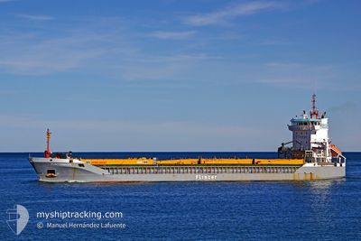
ANGELO
General Cargo
Current Trip
| Trip Time | 4 days |
|---|---|
| Trip Distance | 12.73 nm |
| AVG Speed | 5.8 Knots |
| MAX Speed | 7.9 Knots |
| Dybgang | 7.1 m |
| AVG Wind | 7.1 knots |
| MAX Wind | 11.8 knots |
| MIN Temp | 12.2°C / 53.96°F |
| MAX Temp | 17.1°C / 62.78°F |
| Position Modtaget | 6 d siden |
Current Position
| Longitude | --- |
|---|---|
| Latitude | --- |
| Status | Under way using engine |
| Fart | 10.3 Knots |
| Kurs | 150.6° |
| Område | Mediterranean Sea - Eastern Basin |
| Station | T-AIS |
| Position Modtaget | 6 d siden |
Info
Information
The current position of ANGELO is in Mediterranean Sea - Eastern Basin with coordinates 35.76997° / 28.79693° as reported on 2025-02-24 01:47 by AIS to our vessel tracker app. The vessel's current speed is 10.3 Knots and is currently inside the port of DAMIETTA.
The vessel ANGELO (IMO: 9180877, MMSI: 305791000) is a General Cargo that was built in 1999 ( 26 år gamle ). It's sailing under the flag of [AG] Antigua Barbuda.
In this page you can find informations about the vessels current position, last detected port calls, and current voyage information. If the vessels is not in coverage by AIS you will find the latest position.
The current position of ANGELO is detected by our AIS receivers and we are not responsible for the reliability of the data. The last position was recorded while the vessel was in Coverage by the Ais receivers of our vessel tracking app.
The current draught of ANGELO as reported by AIS is 7.1 meters
Weather
| Temperature | 16.3°C / 61.34°F |
|---|---|
| Wind Speed | 10 knots |
| Direction | 59° ENE |
| Pressure | 1020.6 hPa |
| Humidity | 69.1 % |
| Cloud Coverage | 100 % |
Featured Company
Last Port Calls
Last Trips
| Origin | Departure | Destination | Arrival | Distance | |
|---|---|---|---|---|---|
| 2025-02-25 16:39 | 2025-03-02 08:09 | 12.73 nm | |||
| 2025-02-19 22:08 | 2025-02-25 09:39 | 824.02 nm | |||
| 2025-02-18 12:15 | 2025-02-19 20:49 | 249.54 nm | |||
| 2025-01-29 07:35 | 2025-02-18 11:45 | 650.50 nm | |||
| 2024-12-28 20:48 | 2025-01-07 10:35 | 1335.88 nm |
Events
| Tid | Hændelsen | Detaljer | Position / Dest | Info |
|---|---|---|---|---|
| 2025-03-02 06:47 | STOP Sejllads |
31.46912 / 31.76167
[EG] DAMIETTA
|
Fart: Kurs: -1° |
|
| 2025-03-02 06:09 | Skibe i havn |
|
31.47327 / 31.75683
[EG] DAMIETTA
|
Fart: 7.9 kn Kurs: 191° |
| 2025-03-02 05:42 | START Sejllads | 3.48 nm, North of DAMIETTA |
31.52541 / 31.76315
EGDAM
|
Fart: 5.6 kn Kurs: 175° |
| 2025-03-02 04:56 | STOP Sejllads | 3.76 nm, North of DAMIETTA |
31.53001 / 31.76266
EGDAM
|
Fart: 0.1 kn Kurs: -1° |
| 2025-03-02 04:00 | START Sejllads | 5.84 nm, North of DAMIETTA |
31.56486 / 31.75876
EGDAM
|
Fart: 6.1 kn Kurs: 177° |
| 2025-02-25 15:27 | STOP Sejllads | 6.22 nm, North of DAMIETTA |
31.57126 / 31.75318
EGDAM
|
Fart: 0.1 kn Kurs: -1° |
| 2025-02-25 14:39 | Afsejlet fra sidste havn |
|
31.49692 / 31.76037
EGDAM
|
Fart: 5.7 kn Kurs: -1° |
| 2025-02-25 14:26 | START Sejllads |
31.47313 / 31.75632
[EG] DAMIETTA
|
Fart: 5.7 kn Kurs: -1° |
|
| 2025-02-25 08:10 | STOP Sejllads |
31.46704 / 31.75910
[EG] DAMIETTA
|
Fart: 0.2 kn Kurs: -1° |
|
| 2025-02-25 07:39 | Skibe i havn |
|
31.49079 / 31.75916
[EG] DAMIETTA
|
Fart: 7.1 kn Kurs: 190° |