
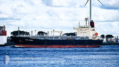
YUFU CROWN
Tanker
Current Trip
| Time Travelled | 9 h, 40 mins |
|---|---|
| Remaining Time | 8 days |
| Distance Travelled | 101.13 nm |
| Remaining Distance | 2238.29 nm |
| AVG Speed | 10 Knots |
| MAX Speed | 12 Knots |
| AVG Wind | 15.1 knots |
| MAX Wind | 20 knots |
| MIN Temp | 4.1°C / 39.38°F |
| MAX Temp | 8.8°C / 47.84°F |
| Draught | 12.2 m |
| Position Received | 35 m ago |
Current Position
| Longitude | -125.54117° |
|---|---|
| Latitude | 48.29877° |
| Status | Under way using engine |
| Speed | 10.8 Knots |
| Course | 247.1° |
| Area | North Pacific Ocean |
| Station | T-AIS |
| Position Received | 35 m ago |
Info
Information
The current position of YUFU CROWN is in North Pacific Ocean with coordinates 48.29877° / -125.54117° as reported on 2024-04-30 11:19 by AIS to our vessel tracker app. The vessel's current speed is 10.8 Knots and is heading at the port of MANZANILLO. The estimated time of arrival as calculated by MyShipTracking vessel tracking app is 2024-05-09 00:20 LT
The vessel YUFU CROWN (IMO: 9822229, MMSI: 538008882) is a Tanker It's sailing under the flag of [MH] Marshall Is.
In this page you can find informations about the vessels current position, last detected port calls, and current voyage information. If the vessels is not in coverage by AIS you will find the latest position.
The current position of YUFU CROWN is detected by our AIS receivers and we are not responsible for the reliability of the data. The last position was recorded while the vessel was in Coverage by the Ais receivers of our vessel tracking app.
The current draught of YUFU CROWN as reported by AIS is 12.2 meters
Weather
| Temperature | 8.2°C / 46.76°F |
|---|---|
| Wind Speed | 12 knots |
| Direction | 85° E |
| Pressure | 1016.7 hPa |
| Humidity | 71.6 % |
| Cloud Coverage | 100 % |
Featured Company
Last Port Calls
| Port | Arrival | Departure | Time In Port |
|---|---|---|---|
| 2024-04-29 11:11 | 2024-04-30 02:14 | 15 h | |
| 2024-04-26 14:13 | 2024-04-29 05:10 | 2 d | |
| 2024-03-03 03:37 | 2024-03-06 18:26 | 3 d | |
| 2024-03-01 00:59 | 2024-03-02 02:44 | 1 d | |
| 2024-02-08 23:25 | 2024-02-10 10:45 | 1 d |
Last Trips
| Origin | Departure | Destination | Arrival | Distance | |
|---|---|---|---|---|---|
| 2024-04-28 22:10 | 2024-04-29 04:11 | 42.22 nm | |||
| 2024-03-06 12:26 | 2024-04-26 07:13 | 6581.47 nm | |||
| 2024-03-01 20:44 | 2024-03-02 21:37 | 33.19 nm | |||
| 2024-02-10 07:45 | 2024-02-29 18:59 | 4309.83 nm | |||
| 2024-01-22 17:17 | 2024-02-08 20:25 | 15.92 nm |
Events
| Time | Event | Details | Position / Dest | Info |
|---|---|---|---|---|
| 2024-04-30 11:26 | Status Changed | Default Under way using engine |
48.29005 / -125.57207
MXZLO
|
Speed: 10.8 kn Course: 247.1° |
| 2024-04-30 11:12 | Status Changed | Under way using engine Default |
48.30649 / -125.51305
MXZLO
|
Speed: 10.5 kn Course: 248° |
| 2024-04-30 10:57 | Status Changed | Default Under way using engine |
48.32320 / -125.45155
MXZLO
|
Speed: 10.8 kn Course: 248.4° |
| 2024-04-30 10:37 | Detected in Sea | Canadian part of the North Pacific Ocean |
48.34614 / -125.36661
North Pacific Ocean
MXZLO
|
Speed: 10.7 kn Course: 246.7° |
| 2024-04-30 10:26 | Status Changed | Under way using engine Default |
48.35884 / -125.31905
MXZLO
|
Speed: 10.6 kn Course: 250° |
| 2024-04-30 10:10 | Status Changed | Default Under way using engine |
48.37656 / -125.25204
MXZLO
|
Speed: 10.7 kn Course: 246.5° |
| 2024-04-30 09:54 | Change Sea Area | United States part of the North Pacific Ocean Canadian part of the North Pacific Ocean |
48.39473 / -125.18474
North Pacific Ocean
MXZLO
|
Speed: 10.9 kn Course: 234.4° |
| 2024-04-30 09:54 | Status Changed | Under way using engine Default |
48.39473 / -125.18474
MXZLO
|
Speed: 11 kn Course: 217° |
| 2024-04-30 09:28 | Status Changed | Default Under way using engine |
48.45875 / -125.11276
MXZLO
|
Speed: 11.1 kn Course: 219.4° |
| 2024-04-30 09:22 | Status Changed | Under way using engine Default |
48.47479 / -125.09565
MXZLO
|
Speed: 11.1 kn Course: 235° |