

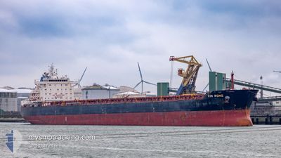
XIN RONG
Bulk Carrier

Current Trip
| Time Travelled | 35 days |
|---|---|
| Remaining Time | --- |
| Distance Travelled | 4700.63 nm |
| Remaining Distance | --- |
| AVG Speed | 10.8 Knots |
| MAX Speed | 13 Knots |
| AVG Wind | 13.2 knots |
| MAX Wind | 36.8 knots |
| MIN Temp | -9.6°C / 14.72°F |
| MAX Temp | 21.7°C / 71.06°F |
| Draught | 14.5 m |
| Position Received | 3 d ago |
Current Position
| Longitude | --- |
|---|---|
| Latitude | --- |
| Status | Under way using engine |
| Speed | 12.2 Knots |
| Course | 203.7° |
| Area | North Atlantic Ocean |
| Station | T-AIS |
| Position Received | 3 d ago |
Information
The current position of XIN RONG is in North Atlantic Ocean with coordinates 27.64173° / -15.22695° as reported on 2025-03-01 06:17 by AIS to our vessel tracker app. The vessel's current speed is 12.2 Knots and is heading at the port of MORMUGAO. The estimated time of arrival as calculated by MyShipTracking vessel tracking app is 2025-03-30 22:05 LT
The vessel XIN RONG (IMO: 9537630, MMSI: 477410100) is a Bulk Carrier that was built in 2010 ( 15 years old ). It's sailing under the flag of [HK] Hong Kong.
In this page you can find informations about the vessels current position, last detected port calls, and current voyage information. If the vessels is not in coverage by AIS you will find the latest position.
The current position of XIN RONG is detected by our AIS receivers and we are not responsible for the reliability of the data. The last position was recorded while the vessel was in Coverage by the Ais receivers of our vessel tracking app.
The current draught of XIN RONG as reported by AIS is 14.5 meters
Weather
| Temperature | 22°C / 71.6°F |
|---|---|
| Wind Speed | 18 knots |
| Direction | 318° NW |
| Pressure | 1009.1 hPa |
| Humidity | 78.5 % |
| Cloud Coverage | 3 % |


Featured Company
Last Port Calls
| Port | Arrival | Departure | Time In Port |
|---|---|---|---|
| 2025-01-19 15:16 | 2025-01-29 00:46 | 9 d | |
| 2025-01-14 13:58 | 2025-01-19 14:38 | 5 d |
Most Visited Ports (Last year)
| Port | Arrivals | |
|---|---|---|
| 4 | ||
| 1 | ||
| 1 | ||
| 1 | ||
| 1 | ||
| 1 |
Last Trips
| Origin | Departure | Destination | Arrival | Distance | |
|---|---|---|---|---|---|
| 2025-01-19 15:38 | 2025-01-19 16:16 | 2.79 nm | |||
| 2024-12-18 14:11 | 2025-01-14 14:58 | 4968.96 nm |
Events
| Time | Event | Details | Position / Dest | Info |
|---|---|---|---|---|
| 2025-03-01 06:23 | Status Changed | Default Under way using engine |
27.62050 / -15.23746
MORMUGAO INDIA
|
Speed: 12.2 kn Course: 203.7° |
| 2025-03-01 06:17 | OUT of Coverage |
27.64173 / -15.22695
North Atlantic Ocean
MORMUGAO INDIA
|
Speed: 12.2 kn Course: 203.7° |
|
| 2025-03-01 06:02 | Status Changed | Under way using engine Default |
27.68641 / -15.20523
MORMUGAO INDIA
|
Speed: 12.4 kn Course: 203° |
| 2025-03-01 05:59 | Status Changed | Default Under way using engine |
27.69594 / -15.20057
MORMUGAO INDIA
|
Speed: 12.3 kn Course: 202.4° |
| 2025-03-01 05:52 | Status Changed | Under way using engine Default |
27.72046 / -15.18893
MORMUGAO INDIA
|
Speed: 12.3 kn Course: 203° |
| 2025-03-01 05:43 | Status Changed | Default Under way using engine |
27.74744 / -15.17622
MORMUGAO INDIA
|
Speed: 12.3 kn Course: 203.8° |
| 2025-03-01 00:35 | Status Changed | Under way using engine Default |
28.71569 / -14.80381
MORMUGAO INDIA
|
Speed: 11.8 kn Course: 194° |
| 2025-03-01 00:32 | Status Changed | Default Under way using engine |
28.72590 / -14.80094
MORMUGAO INDIA
|
Speed: 11.9 kn Course: 194.3° |
| 2025-03-01 00:31 | Status Changed | Under way using engine Default |
28.72757 / -14.80048
MORMUGAO INDIA
|
Speed: 12 kn Course: 195° |
| 2025-03-01 00:23 | Status Changed | Default Under way using engine |
28.75369 / -14.79370
MORMUGAO INDIA
|
Speed: 11.9 kn Course: 193.4° |