
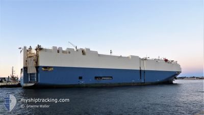
WISTERIA ACE
Vehicles Carrier
Current Trip
| Time Travelled | 23 days |
|---|---|
| Remaining Time | --- |
| Distance Travelled | 9200.70 nm |
| Remaining Distance | --- |
| AVG Speed | 16.7 Knots |
| MAX Speed | 21.8 Knots |
| AVG Wind | 11.8 knots |
| MAX Wind | 28 knots |
| MIN Temp | 7.1°C / 44.78°F |
| MAX Temp | 30.8°C / 87.44°F |
| Draught | 9.1 m |
| Position Received | 15 h, 38 m ago |
Current Position
| Longitude | -76.68840° |
|---|---|
| Latitude | 26.76452° |
| Status | Under way using engine |
| Speed | 13.1 Knots |
| Course | 320.4° |
| Area | North Atlantic Ocean |
| Station | T-AIS |
| Position Received | 15 h, 38 m ago |
Info
Information
The current position of WISTERIA ACE is in North Atlantic Ocean with coordinates 26.76452° / -76.68840° as reported on 2024-05-21 21:22 by AIS to our vessel tracker app. The vessel's current speed is 13.1 Knots and is heading at the port of BALBOA. The estimated time of arrival as calculated by MyShipTracking vessel tracking app is 2024-05-17 17:00 LT
The vessel WISTERIA ACE (IMO: 9355197, MMSI: 636016420) is a Vehicles Carrier that was built in 2007 ( 17 years old ). It's sailing under the flag of [LR] Liberia.
In this page you can find informations about the vessels current position, last detected port calls, and current voyage information. If the vessels is not in coverage by AIS you will find the latest position.
The current position of WISTERIA ACE is detected by our AIS receivers and we are not responsible for the reliability of the data. The last position was recorded while the vessel was in Coverage by the Ais receivers of our vessel tracking app.
The current draught of WISTERIA ACE as reported by AIS is 9.1 meters
Weather
| Temperature | 24.7°C / 76.46°F |
|---|---|
| Wind Speed | 11 knots |
| Direction | 67° ENE |
| Pressure | 1016.3 hPa |
| Humidity | 68.1 % |
| Cloud Coverage | --- |
Featured Company
Last Port Calls
| Port | Arrival | Departure | Time In Port |
|---|---|---|---|
| 2024-04-29 12:51 | 2024-04-29 18:05 | 5 h | |
| 2024-04-26 06:38 | 2024-04-26 16:20 | 9 h | |
| 2024-04-23 07:16 | 2024-04-23 19:07 | 11 h | |
| 2024-04-20 17:40 | |||
| 2024-04-18 05:54 | |||
| 2024-04-16 06:39 | 2024-04-16 20:00 | 13 h | |
| 2024-04-12 06:03 | 2024-04-12 12:55 | 6 h | |
| 2024-04-06 00:07 | 2024-04-07 21:55 | 1 d | |
| 2024-03-30 05:10 | 2024-03-30 11:00 | 5 h | |
| 2024-03-28 02:18 | 2024-03-28 14:20 | 12 h |
Last Trips
| Origin | Departure | Destination | Arrival | Distance | |
|---|---|---|---|---|---|
| 2024-04-26 16:20 | 2024-04-29 12:51 | 452.09 nm | |||
| 2024-04-23 19:07 | 2024-04-26 06:38 | 447.55 nm | |||
| 2024-04-20 17:40 | 2024-04-23 07:16 | 593.93 nm | |||
| 2024-04-16 20:00 | 2024-04-18 05:54 | 553.33 nm | |||
| 2024-04-12 12:55 | 2024-04-16 06:39 | 1181.65 nm | |||
| 2024-04-07 21:55 | 2024-04-12 06:03 | 1822.71 nm | |||
| 2024-03-30 11:00 | 2024-04-06 00:07 | 1921.80 nm | |||
| 2024-03-28 14:20 | 2024-03-30 05:10 | 639.03 nm | |||
| 2024-03-25 20:25 | 2024-03-28 02:18 | 768.48 nm |
Events
| Time | Event | Details | Position / Dest | Info |
|---|---|---|---|---|
| 2024-05-21 21:26 | Status Changed | Default Under way using engine |
26.77500 / -76.69833
PA BLB
|
Speed: 13.1 kn Course: 320.4° |
| 2024-05-21 21:22 | Status Changed | Under way using engine Default |
26.76452 / -76.68840
PA BLB
|
Speed: 13 kn Course: 321° |
| 2024-05-21 21:22 | IN Coverage |
26.76452 / -76.68840
North Atlantic Ocean
|
Speed: 13.1 kn Course: 320.4° |
|
| 2024-05-21 21:22 | OUT of Coverage |
26.76452 / -76.68840
North Atlantic Ocean
|
Speed: 13.1 kn Course: 320.4° |
|
| 2024-05-20 23:56 | Status Changed | Default Under way using engine |
21.85333 / -74.63834
PA BLB
|
Speed: 17.6 kn Course: 336.8° |
| 2024-05-20 23:35 | OUT of Coverage |
21.72744 / -74.58057
North Atlantic Ocean
|
Speed: 17.6 kn Course: 336.8° |
|
| 2024-05-20 23:28 | Change Sea Area | Bahamas part of the North Atlantic Ocean Mexican part of the North Pacific Ocean |
21.72699 / -74.58036
North Atlantic Ocean
|
Speed: 17.6 kn Course: 336.9° |
| 2024-05-20 23:27 | Status Changed | Under way using engine Default |
21.72426 / -74.57913
PA BLB
|
Speed: 17 kn Course: 336° |
| 2024-05-20 23:26 | IN Coverage |
21.72699 / -74.58036
North Atlantic Ocean
|
Speed: 17.6 kn Course: 336.9° |
|
| 2024-05-18 14:06 | START Moving | 3.98 nm, South of CRISTOBAL |
9.28091 / -79.92217
PA BLB
|
Speed: 3.4 kn Course: 7° |