
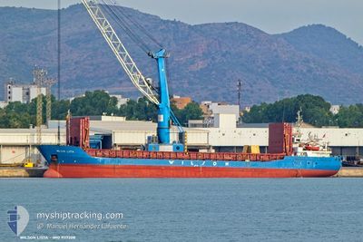
WILSON LISTA
General Cargo
Current Trip
NOKRS => NOJOS
| Time Travelled | 1 day |
|---|---|
| Remaining Time | --- |
| Distance Travelled | 85.44 nm |
| Remaining Distance | --- |
| AVG Speed | 7.1 Knots |
| MAX Speed | 10.4 Knots |
| AVG Wind | 19.2 knots |
| MAX Wind | 23 knots |
| MIN Temp | 8.5°C / 47.3°F |
| MAX Temp | 9.1°C / 48.38°F |
| Draught | 3.5 m |
| Position Received | 6 h, 2 m ago |
Current Position
| Longitude | --- |
|---|---|
| Latitude | --- |
| Status | Under way using engine |
| Speed | |
| Course | 20° |
| Area | North Sea |
| Station | T-AIS |
| Position Received | 6 h, 2 m ago |
Info
Information
The current position of WILSON LISTA is in North Sea with coordinates 58.32404° / 6.35177° as reported on 2025-12-15 22:56 by AIS to our vessel tracker app. The vessel's current speed is 0 Knots
The vessel WILSON LISTA (IMO: 9117208, MMSI: 257904000) is a General Cargo that was built in 1994 ( 31 years old ). It's sailing under the flag of [NO] Norway.
In this page you can find informations about the vessels current position, last detected port calls, and current voyage information. If the vessels is not in coverage by AIS you will find the latest position.
The current position of WILSON LISTA is detected by our AIS receivers and we are not responsible for the reliability of the data. The last position was recorded while the vessel was in Coverage by the Ais receivers of our vessel tracking app.
The current draught of WILSON LISTA as reported by AIS is 3.5 meters
Weather
| Temperature | 8.5°C / 47.3°F |
|---|---|
| Wind Speed | 15 knots |
| Direction | 189° S |
| Pressure | 1005 hPa |
| Humidity | 94.9 % |
| Cloud Coverage | 100 % |
Featured Company
Last Port Calls
| Port | Arrival | Departure | Time In Port |
|---|---|---|---|
| 2025-12-09 17:10 | 2025-12-15 05:54 | 5 d | |
| 2025-12-07 03:01 | 2025-12-07 21:45 | 18 h | |
| 2025-12-03 17:52 | 2025-12-05 18:02 | 2 d | |
| 2025-11-30 17:18 | 2025-12-01 13:20 | 20 h | |
| 2025-11-28 22:31 | 2025-11-29 15:00 | 16 h | |
| 2025-11-27 11:09 | 2025-11-28 22:18 | 1 d | |
| 2025-11-20 13:17 | 2025-11-22 18:00 | 2 d | |
| 2025-11-14 03:36 | 2025-11-17 18:50 | 3 d | |
| 2025-11-11 13:52 | 2025-11-12 19:06 | 1 d | |
| 2025-11-08 22:15 | 2025-11-09 18:39 | 20 h |
Last Trips
| Origin | Departure | Destination | Arrival | Distance | |
|---|---|---|---|---|---|
| 2025-12-07 21:45 | 2025-12-09 17:10 | 407.25 nm | |||
| 2025-12-05 18:02 | 2025-12-07 03:01 | 71.19 nm | |||
| 2025-12-01 13:20 | 2025-12-03 17:52 | 402.22 nm | |||
| 2025-11-29 15:00 | 2025-11-30 17:18 | 296.80 nm | |||
| 2025-11-28 22:18 | 2025-11-28 22:31 | 0.90 nm | |||
| 2025-11-22 18:00 | 2025-11-27 11:09 | 1025.59 nm | |||
| 2025-11-17 18:50 | 2025-11-20 13:17 | 589.60 nm | |||
| 2025-11-12 19:06 | 2025-11-14 03:36 | 264.48 nm | |||
| 2025-11-09 18:39 | 2025-11-11 13:52 | 448.87 nm | |||
| 2025-11-08 03:27 | 2025-11-08 22:15 | 224.45 nm |
Events
| Time | Event | Details | Position / Dest | Info |
|---|---|---|---|---|
| 2025-12-15 23:08 | Status Changed | Default Under way using engine |
58.32333 / 6.35167
NOKRS => NOJOS
|
Speed: Course: 20° |
| 2025-12-15 22:56 | Status Changed | Under way using engine Default |
58.32404 / 6.35177
NOKRS => NOJOS
|
Speed: Course: 20° |
| 2025-12-15 22:56 | OUT of Coverage |
58.32404 / 6.35177
North Sea
|
Speed: Course: 214.5° |
|
| 2025-12-15 22:41 | IN Coverage |
58.32404 / 6.35177
North Sea
|
Speed: Course: 214.5° |
|
| 2025-12-15 19:54 | Status Changed | Default Under way using engine |
58.32398 / 6.35183
NOKRS => NOJOS
|
Speed: Course: 20° |
| 2025-12-15 19:44 | Status Changed | Under way using engine Default |
58.32397 / 6.35178
NOKRS => NOJOS
|
Speed: 0.1 kn Course: 20° |
| 2025-12-15 19:44 | IN Coverage |
58.32397 / 6.35178
North Sea
|
Speed: Course: 214.5° |
|
| 2025-12-15 19:44 | OUT of Coverage |
58.32397 / 6.35178
North Sea
|
Speed: Course: 214.5° |
|
| 2025-12-15 16:00 | OUT of Coverage |
58.31200 / 6.32837
North Sea
NOKRS => NOJOS
|
Speed: 9.9 kn Course: 37.9° |
|
| 2025-12-15 10:51 | Change Sea Area | Norwegian part of the North Sea Norwegian part of the Skaggerak |
57.89933 / 7.17044
North Sea
NOKRS => NOJOS
|
Speed: 7.9 kn Course: 268.8° |