
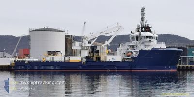
VIRGINIA ANN
Military ops
Current Trip
ST JOHNS
| Time Travelled | 7 days |
|---|---|
| Remaining Time | --- |
| Distance Travelled | 15.96 nm |
| Remaining Distance | --- |
| AVG Speed | 9.4 Knots |
| MAX Speed | 9.6 Knots |
| AVG Wind | 10.9 knots |
| MAX Wind | 12 knots |
| MIN Temp | 2.9°C / 37.22°F |
| MAX Temp | 3.8°C / 38.84°F |
| Draught | 7 m |
| Position Received | 7 d ago |
Current Position
| Longitude | -52.58667° |
|---|---|
| Latitude | 47.28769° |
| Status | Moored |
| Speed | 9.1 Knots |
| Course | 185.6° |
| Area | North Atlantic Ocean |
| Station | T-AIS |
| Position Received | 7 d ago |
Info
Information
The current position of VIRGINIA ANN is in North Atlantic Ocean with coordinates 47.28769° / -52.58667° as reported on 2024-05-13 15:05 by AIS to our vessel tracker app. The vessel's current speed is 9.1 Knots
The vessel VIRGINIA ANN (IMO: 9645657, MMSI: 369331000) is a Military ops It's sailing under the flag of [US] USA.
In this page you can find informations about the vessels current position, last detected port calls, and current voyage information. If the vessels is not in coverage by AIS you will find the latest position.
The current position of VIRGINIA ANN is detected by our AIS receivers and we are not responsible for the reliability of the data. The last position was recorded while the vessel was in Coverage by the Ais receivers of our vessel tracking app.
The current draught of VIRGINIA ANN as reported by AIS is 7 meters
Weather
| Temperature | 3.8°C / 38.84°F |
|---|---|
| Wind Speed | 10 knots |
| Direction | 163° SSE |
| Pressure | 1017.3 hPa |
| Humidity | 87.1 % |
| Cloud Coverage | 100 % |
Featured Company
Last Port Calls
| Port | Arrival | Departure | Time In Port |
|---|---|---|---|
| 2024-05-11 09:04 | 2024-05-13 12:49 | 2 d | |
| 2024-05-02 14:34 | 2024-05-05 18:46 | 3 d | |
| 2024-04-27 07:33 | 2024-05-02 07:59 | 5 d | |
| 2024-03-29 11:05 | 2024-04-05 15:11 | 7 d | |
| 2024-03-08 12:41 | 2024-03-09 13:02 | 1 d | |
| 2024-03-01 19:47 |
Last Trips
| Origin | Departure | Destination | Arrival | Distance | |
|---|---|---|---|---|---|
| 2024-05-05 16:16 | 2024-05-11 06:34 | 54.50 nm | |||
| 2024-05-02 05:29 | 2024-05-02 12:04 | 28.31 nm | |||
| 2024-04-05 12:41 | 2024-04-27 05:03 | 1095.18 nm | |||
| 2024-03-09 08:02 | 2024-03-29 08:35 | 1401.85 nm | |||
| 2024-03-01 14:47 | 2024-03-08 07:41 | 1125.89 nm |
Events
| Time | Event | Details | Position / Dest | Info |
|---|---|---|---|---|
| 2024-05-13 15:05 | OUT of Coverage |
47.28769 / -52.58667
North Atlantic Ocean
|
Speed: 9.1 kn Course: 185.6° |
|
| 2024-05-13 14:53 | IN Coverage |
47.31936 / -52.58143
North Atlantic Ocean
|
Speed: 9.5 kn Course: 187.2° |
|
| 2024-05-13 13:24 | OUT of Coverage |
47.53966 / -52.56251
North Atlantic Ocean
|
Speed: 9.3 kn Course: 120.9° |
|
| 2024-05-13 13:18 | Detected in Sea | Canadian part of the North Atlantic Ocean |
47.54731 / -52.58393
North Atlantic Ocean
|
Speed: 9.5 kn Course: 120.9° |
| 2024-05-13 12:49 | PORT DEPARTURE |
|
47.54731 / -52.58393
ST JOHNS
|
Speed: 6.2 kn Course: 94° |
| 2024-05-13 12:45 | IN Coverage |
47.56663 / -52.69226
Labrador Sea
[CA] ST JOHNS
|
Speed: 6.2 kn Course: 98.7° |
|
| 2024-05-13 11:01 | OUT of Coverage |
47.56516 / -52.70405
Labrador Sea
[CA] ST JOHNS
|
Speed: Course: 134.5° |
|
| 2024-05-13 11:01 | IN Coverage |
47.56516 / -52.70405
Labrador Sea
[CA] ST JOHNS
|
Speed: Course: 134.5° |
|
| 2024-05-13 07:34 | OUT of Coverage |
47.56515 / -52.70406
Labrador Sea
[CA] ST JOHNS
|
Speed: Course: 134.5° |
|
| 2024-05-13 00:37 | IN Coverage |
47.56515 / -52.70405
Labrador Sea
[CA] ST JOHNS
|
Speed: Course: 134.5° |