

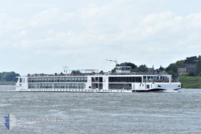
VIKING ROLF
Passenger

Current Trip
| Time Travelled | 4 days |
|---|---|
| Remaining Time | --- |
| Distance Travelled | 190.32 nm |
| Remaining Distance | --- |
| AVG Speed | 9.8 Knots |
| MAX Speed | 12.2 Knots |
| AVG Wind | 2.6 knots |
| MAX Wind | 10 knots |
| MIN Temp | 4.8°C / 40.64°F |
| MAX Temp | 15.7°C / 60.26°F |
| Draught | 1.8 m |
| Position Received | 15 h, 30 m ago |
Current Position
| Longitude | --- |
|---|---|
| Latitude | --- |
| Status | Under way using engine |
| Speed | 8.7 Knots |
| Course | 336.4° |
| Area | North Sea |
| Station | T-AIS |
| Position Received | 15 h, 30 m ago |
Information
The current position of VIKING ROLF is in North Sea with coordinates 50.14028° / 7.72522° as reported on 2025-03-29 09:27 by AIS to our vessel tracker app. The vessel's current speed is 8.7 Knots
The vessel VIKING ROLF (MMSI: 269057548) is a Passenger It's sailing under the flag of [CH] Switzerland.
In this page you can find informations about the vessels current position, last detected port calls, and current voyage information. If the vessels is not in coverage by AIS you will find the latest position.
The current position of VIKING ROLF is detected by our AIS receivers and we are not responsible for the reliability of the data. The last position was recorded while the vessel was in Coverage by the Ais receivers of our vessel tracking app.
The current draught of VIKING ROLF as reported by AIS is 1.8 meters
Weather
| Temperature | 8.6°C / 47.48°F |
|---|---|
| Wind Speed | 9 knots |
| Direction | 344° NNW |
| Pressure | 1016.6 hPa |
| Humidity | 64.7 % |
| Cloud Coverage | 100 % |


Featured Company
Last Port Calls
| Port | Arrival | Departure | Time In Port |
|---|---|---|---|
| 2025-03-25 07:03 | 2025-03-25 19:43 | 12 h | |
| 2025-03-25 02:44 | 2025-03-25 06:58 | 4 h | |
| 2025-03-20 09:34 | 2025-03-20 22:52 | 13 h | |
| 2025-03-19 02:59 | 2025-03-19 03:20 | 21 m | |
| 2025-03-18 04:20 | 2025-03-18 23:57 | 19 h | |
| 2025-03-18 00:24 | 2025-03-18 00:43 | 19 m | |
| 2025-02-04 12:12 | 2025-03-17 12:06 | ||
| 2025-01-28 04:28 | 2025-02-03 13:30 | 6 d | |
| 2025-01-27 13:08 |
Last Trips
| Origin | Departure | Destination | Arrival | Distance | |
|---|---|---|---|---|---|
| 2025-03-25 06:58 | 2025-03-25 07:03 | 0.31 nm | |||
| 2025-03-20 22:52 | 2025-03-25 02:44 | 243.19 nm | |||
| 2025-03-19 03:20 | 2025-03-20 09:34 | 163.47 nm | |||
| 2025-03-18 23:57 | 2025-03-19 02:59 | 23.39 nm | |||
| 2025-03-18 00:43 | 2025-03-18 04:20 | 29.99 nm | |||
| 2025-03-17 12:06 | 2025-03-18 00:24 | 109.94 nm | |||
| 2025-02-03 13:30 | 2025-02-04 12:12 | 138.09 nm | |||
| 2025-01-27 13:08 | 2025-01-28 04:28 | 147.92 nm |
Events
| Time | Event | Details | Position / Dest | Info |
|---|---|---|---|---|
| 2025-03-29 09:27 | OUT of Coverage |
50.14028 / 7.72522
North Sea
AMSTERDAM
|
Speed: 8.7 kn Course: 336.4° |
|
| 2025-03-29 08:49 | IN Coverage |
50.06166 / 7.77339
North Sea
AMSTERDAM
|
Speed: 9.9 kn Course: 5.5° |
|
| 2025-03-28 15:32 | OUT of Coverage |
49.97938 / 7.97059
North Sea
AMSTERDAM
|
Speed: 9.5 kn Course: 249.6° |
|
| 2025-03-28 12:03 | IN Coverage |
49.75043 / 8.46575
North Sea
AMSTERDAM
|
Speed: 11 kn Course: 50.5° |
|
| 2025-03-28 10:39 | OUT of Coverage |
49.61361 / 8.39689
North Sea
AMSTERDAM
|
Speed: 12.2 kn Course: 308.6° |
|
| 2025-03-28 09:33 | Status Changed | Under way using engine Default |
49.44921 / 8.44306
AMSTERDAM
|
Speed: 9.3 kn Course: 264° |
| 2025-03-28 09:25 | Status Changed | Default Under way using engine |
49.44352 / 8.47461
AMSTERDAM
|
Speed: 9.7 kn Course: 273.6° |
| 2025-03-28 08:52 | IN Coverage |
49.37662 / 8.50066
North Sea
AMSTERDAM
|
Speed: 9.6 kn Course: 3.4° |
|
| 2025-03-28 02:22 | OUT of Coverage |
49.20004 / 8.38476
North Sea
AMSTERDAM
|
Speed: 9.9 kn Course: 11.5° |
|
| 2025-03-28 00:53 | Destination Changed | AMSTERDAM BASEL |
48.97616 / 8.25219
AMSTERDAM
|
Speed: 10.5 kn Course: 56.9° |