

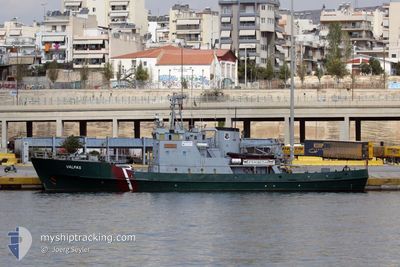
VALPAS
Law Enforcement

Current Trip
CRETE
| Time Travelled | 3 days |
|---|---|
| Remaining Time | --- |
| Distance Travelled | 105.06 nm |
| Remaining Distance | --- |
| AVG Speed | 5 Knots |
| MAX Speed | 12.9 Knots |
| AVG Wind | 11.4 knots |
| MAX Wind | 15.7 knots |
| MIN Temp | 15.4°C / 59.72°F |
| MAX Temp | 17°C / 62.6°F |
| Draught | 4.3 m |
| Position Received | 7 d ago |
Current Position
| Longitude | --- |
|---|---|
| Latitude | --- |
| Status | Under way using engine |
| Speed | 13.1 Knots |
| Course | 177.1° |
| Area | Mediterranean Sea - Eastern Basin |
| Station | T-AIS |
| Position Received | 7 d ago |
Information
The current position of VALPAS is in Mediterranean Sea - Eastern Basin with coordinates 35.37550° / 23.45104° as reported on 2025-03-21 01:29 by AIS to our vessel tracker app. The vessel's current speed is 13.1 Knots
The vessel VALPAS (IMO: 4589731, MMSI: 275093000) is a Law Enforcement It's sailing under the flag of [LV] Latvia.
In this page you can find informations about the vessels current position, last detected port calls, and current voyage information. If the vessels is not in coverage by AIS you will find the latest position.
The current position of VALPAS is detected by our AIS receivers and we are not responsible for the reliability of the data. The last position was recorded while the vessel was in Coverage by the Ais receivers of our vessel tracking app.
The current draught of VALPAS as reported by AIS is 4.3 meters
Weather
| Temperature | 17.1°C / 62.78°F |
|---|---|
| Wind Speed | 16 knots |
| Direction | 109° ESE |
| Pressure | 1015.8 hPa |
| Humidity | 78.3 % |
| Cloud Coverage | 100 % |


Featured Company
Last Port Calls
| Port | Arrival | Departure | Time In Port |
|---|---|---|---|
| 2025-03-21 09:16 | 2025-03-25 05:00 | 3 d | |
| 2025-03-20 10:59 | 2025-03-20 14:37 | 3 h | |
| 2025-03-13 14:36 | 2025-03-20 10:32 | 6 d | |
| 2025-03-13 12:50 |
Most Visited Ports (Last year)
| Port | Arrivals | |
|---|---|---|
| 1 | ||
| 1 | ||
| 1 |
Events
| Time | Event | Details | Position / Dest | Info |
|---|---|---|---|---|
| 2025-03-26 00:06 | START Moving | 1.28 nm, North East of GAVDOS |
34.86104 / 24.13771
CRETE
|
Speed: 3.6 kn Course: 356° |
| 2025-03-25 21:48 | STOP Moving | 2.96 nm, South of GAVDOS |
34.79826 / 24.12526
CRETE
|
Speed: 0.3 kn Course: 291° |
| 2025-03-25 03:02 | START Moving | 0.36 nm, South of AGIA GALINI |
35.08960 / 24.68875
CRETE
|
Speed: 11.7 kn Course: 218° |
| 2025-03-25 03:00 | PORT DEPARTURE |
|
35.08960 / 24.68875
CRETE
|
Speed: Course: 63° |
| 2025-03-21 07:31 | STOP Moving |
35.09479 / 24.69033
[GR] AGIA GALINI
|
Speed: Course: 63° |
|
| 2025-03-21 07:16 | PORT ARRIVAL |
|
35.09486 / 24.69037
[GR] AGIA GALINI
|
Speed: 4.7 kn Course: 357° |
| 2025-03-21 01:29 | OUT of Coverage |
35.37550 / 23.45104
Mediterranean Sea - Eastern Basin
CRETE
|
Speed: 13.1 kn Course: 177.1° |
|
| 2025-03-21 00:33 | Detected in Sea | Greek part of the Mediterranean Sea - Eastern Basin |
35.57776 / 23.44135
Mediterranean Sea - Eastern Basin
CRETE
|
Speed: 12.9 kn Course: 177.6° |
| 2025-03-21 00:33 | IN Coverage |
35.57776 / 23.44135
Mediterranean Sea - Eastern Basin
CRETE
|
Speed: 12.9 kn Course: 177.6° |
|
| 2025-03-20 14:31 | OUT of Coverage |
37.57164 / 23.74564
Aegean Sea
CRETE
|
Speed: 12.7 kn Course: 166.6° |