
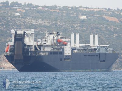
USNS STOCKHAM
Logistics Naval Vessel
Current Trip
,
| Time Travelled | 1 day |
|---|---|
| Remaining Time | --- |
| Distance Travelled | 213.72 nm |
| Remaining Distance | --- |
| AVG Speed | 21.5 Knots |
| MAX Speed | 21.5 Knots |
| AVG Wind | 4.7 knots |
| MAX Wind | 9.2 knots |
| MIN Temp | 25.5°C / 77.9°F |
| MAX Temp | 27.3°C / 81.14°F |
| Draught | 0 m |
| Position Received | 1 d ago |
Current Position
| Longitude | 34.26971° |
|---|---|
| Latitude | 31.59435° |
| Status | Under way using engine |
| Speed | 5.8 Knots |
| Course | 137° |
| Area | Mediterranean Sea - Eastern Basin |
| Station | T-AIS |
| Position Received | 1 d ago |
Info
Information
The current position of USNS STOCKHAM is in Mediterranean Sea - Eastern Basin with coordinates 31.59435° / 34.26971° as reported on 2024-06-07 13:53 by AIS to our vessel tracker app. The vessel's current speed is 5.8 Knots
The vessel USNS STOCKHAM (IMO: 7825423, MMSI: 367211000) is a Logistics Naval Vessel that was built in 1981 ( 43 years old ). It's sailing under the flag of [US] USA.
In this page you can find informations about the vessels current position, last detected port calls, and current voyage information. If the vessels is not in coverage by AIS you will find the latest position.
The current position of USNS STOCKHAM is detected by our AIS receivers and we are not responsible for the reliability of the data. The last position was recorded while the vessel was in Coverage by the Ais receivers of our vessel tracking app.
Weather
| Temperature | 26.6°C / 79.88°F |
|---|---|
| Wind Speed | 6 knots |
| Direction | 326° NW |
| Pressure | 1006.9 hPa |
| Humidity | 75.8 % |
| Cloud Coverage | 1 % |
Featured Company
Last Port Calls
| Port | Arrival | Departure | Time In Port |
|---|---|---|---|
| 2024-06-07 05:07 | 2024-06-07 06:13 | 1 h | |
| 2024-06-07 00:57 | 2024-06-07 05:04 | 4 h | |
| 2024-06-06 20:08 | 2024-06-07 00:56 | 4 h | |
| 2024-06-05 20:55 | |||
| 2024-06-03 08:14 | 2024-06-03 08:20 | 5 m | |
| 2024-06-02 19:48 | 2024-06-03 06:08 | 10 h | |
| 2024-06-01 15:46 | |||
| 2024-06-01 13:47 | 2024-06-01 15:24 | 1 h | |
| 2024-06-01 13:23 | 2024-06-01 13:42 | 19 m | |
| 2024-06-01 11:28 | 2024-06-01 12:48 | 1 h |
Most Visited Ports (Last year)
| Port | Arrivals | |
|---|---|---|
| 18 | ||
| 2 | ||
| 1 | ||
| 1 |
Last Trips
| Origin | Departure | Destination | Arrival | Distance | |
|---|---|---|---|---|---|
| 2024-06-07 05:04 | 2024-06-07 05:07 | 1.75 nm | |||
| 2024-06-07 00:56 | 2024-06-07 00:57 | 1.91 nm | |||
| 2024-06-07 00:56 | 2024-06-06 20:08 | 1.91 nm | |||
| 2024-06-03 08:20 | 2024-06-05 20:55 | 469.60 nm | |||
| 2024-06-03 06:08 | 2024-06-03 08:14 | 11.69 nm | |||
| 2024-06-03 06:08 | 2024-06-02 19:48 | 11.69 nm | |||
| 2024-06-01 15:24 | 2024-06-01 15:46 | 7.97 nm | |||
| 2024-06-01 13:42 | 2024-06-01 13:47 | 1.04 nm | |||
| 2024-06-01 12:48 | 2024-06-01 13:23 | 2.31 nm | |||
| 2024-06-01 12:48 | 2024-06-01 11:28 | 2.31 nm |
Events
| Time | Event | Details | Position / Dest | Info |
|---|---|---|---|---|
| 2024-06-07 13:53 | OUT of Coverage |
31.59435 / 34.26971
Mediterranean Sea - Eastern Basin
|
Speed: 5.8 kn Course: 137° |
|
| 2024-06-07 13:53 | Status Changed | Under way using engine Default |
31.59435 / 34.26971
,
|
Speed: 39.9 kn Course: 131° |
| 2024-06-07 13:49 | Status Changed | Default Under way using engine |
31.59786 / 34.26390
,
|
Speed: 18.4 kn Course: 139.8° |
| 2024-06-07 11:23 | Status Changed | Under way using engine Default |
32.36620 / 34.04557
,
|
Speed: 19.8 kn Course: 186° |
| 2024-06-07 11:21 | Status Changed | Default Under way using engine |
32.37781 / 34.04462
,
|
Speed: 23.5 kn Course: 281.2° |
| 2024-06-07 10:51 | Status Changed | Under way using engine Default |
32.54445 / 34.03007
,
|
Speed: 19.2 kn Course: 180° |
| 2024-06-07 10:49 | Status Changed | Default Under way using engine |
32.55397 / 34.02911
,
|
Speed: 19.7 kn Course: 174.4° |
| 2024-06-07 10:32 | Status Changed | Under way using engine Default |
32.64823 / 34.01819
,
|
Speed: 5.8 kn Course: 317° |
| 2024-06-07 10:25 | Status Changed | Default Under way using engine |
32.68545 / 34.01301
,
|
Speed: 19.9 kn Course: 172.9° |
| 2024-06-07 10:18 | Status Changed | Under way using engine Default |
32.72496 / 34.00770
,
|
Speed: 19.9 kn Course: 174° |