

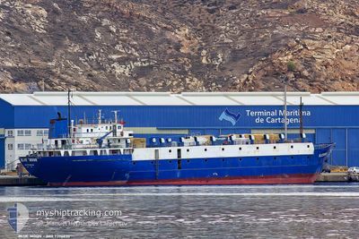
TULEEN
Livestock Carrier

Current Trip
| Time Travelled | 4 days |
|---|---|
| Remaining Time | 1 day |
| Distance Travelled | 997.75 nm |
| Remaining Distance | 460.02 nm |
| AVG Speed | 10.2 Knots |
| MAX Speed | 11.4 Knots |
| AVG Wind | 7.7 knots |
| MAX Wind | 19 knots |
| MIN Temp | 5.6°C / 42.08°F |
| MAX Temp | 15.5°C / 59.9°F |
| Draught | 4 m |
| Position Received | 3 h, 57 m ago |
Current Position
| Longitude | --- |
|---|---|
| Latitude | --- |
| Status | Under way using engine |
| Speed | 10 Knots |
| Course | 299.1° |
| Area | Adriatic Sea |
| Station | T-AIS |
| Position Received | 3 h, 57 m ago |
Information
The current position of TULEEN is in Adriatic Sea with coordinates 39.86165° / 19.84780° as reported on 2025-02-27 22:26 by AIS to our vessel tracker app. The vessel's current speed is 10 Knots and is heading at the port of KOPER. The estimated time of arrival as calculated by MyShipTracking vessel tracking app is 2025-03-01 23:41 LT
The vessel TULEEN (IMO: 7396630, MMSI: 511100448) is a Livestock Carrier that was built in 1975 ( 50 years old ). It's sailing under the flag of [PW] Palau.
In this page you can find informations about the vessels current position, last detected port calls, and current voyage information. If the vessels is not in coverage by AIS you will find the latest position.
The current position of TULEEN is detected by our AIS receivers and we are not responsible for the reliability of the data. The last position was recorded while the vessel was in Coverage by the Ais receivers of our vessel tracking app.
The current draught of TULEEN as reported by AIS is 4 meters
Weather
| Temperature | 14.2°C / 57.56°F |
|---|---|
| Wind Speed | 4 knots |
| Direction | 197° SSW |
| Pressure | 1018.1 hPa |
| Humidity | 65.4 % |
| Cloud Coverage | 100 % |


Featured Company
Last Port Calls
| Port | Arrival | Departure | Time In Port |
|---|---|---|---|
| 2025-02-23 15:43 | 2025-02-24 00:20 | 8 h | |
| 2025-02-15 19:05 | 2025-02-16 16:49 | 21 h | |
| 2025-02-10 05:54 | 2025-02-10 14:49 | 8 h | |
| 2025-02-05 05:37 | 2025-02-05 17:37 | 11 h | |
| 2025-01-29 13:30 | 2025-01-30 03:03 | 13 h | |
| 2025-01-23 12:51 | |||
| 2025-01-16 07:10 | 2025-01-16 18:28 | 11 h | |
| 2025-01-10 23:36 | 2025-01-11 17:00 | 17 h | |
| 2025-01-04 15:13 | 2025-01-05 15:54 | 1 d | |
| 2024-12-30 04:41 | 2024-12-30 21:45 | 17 h |
Last Trips
| Origin | Departure | Destination | Arrival | Distance | |
|---|---|---|---|---|---|
| 2025-02-16 16:49 | 2025-02-23 15:43 | 1239.62 nm | |||
| 2025-02-10 14:49 | 2025-02-15 19:05 | 1088.95 nm | |||
| 2025-02-05 17:37 | 2025-02-10 05:54 | 1060.56 nm | |||
| 2025-01-30 03:03 | 2025-02-05 05:37 | 1166.31 nm | |||
| 2025-01-23 12:51 | 2025-01-29 13:30 | 1374.20 nm | |||
| 2025-01-11 17:00 | 2025-01-16 07:10 | 1068.18 nm | |||
| 2025-01-05 15:54 | 2025-01-10 23:36 | 1120.75 nm | |||
| 2024-12-30 21:45 | 2025-01-04 15:13 | 1057.56 nm | |||
| 2024-12-19 16:07 | 2024-12-30 04:41 | 1435.19 nm | |||
| 2024-12-14 05:36 | 2024-12-19 01:18 | 1068.83 nm |
Events
| Time | Event | Details | Position / Dest | Info |
|---|---|---|---|---|
| 2025-02-27 22:27 | Status Changed | Default Under way using engine |
39.86230 / 19.84623
KOPER
|
Speed: 10 kn Course: 299.1° |
| 2025-02-27 22:26 | OUT of Coverage |
39.86165 / 19.84780
Adriatic Sea
KOPER
|
Speed: 10 kn Course: 299.1° |
|
| 2025-02-27 21:49 | Change Sea Area | Greek part of the Adriatic Sea Albanian part of the Adriatic Sea |
39.81200 / 19.96919
Adriatic Sea
KOPER
|
Speed: 11.1 kn Course: 315.3° |
| 2025-02-27 21:40 | Change Sea Area | Albanian part of the Adriatic Sea Greek part of the Adriatic Sea |
39.78903 / 19.98119
Adriatic Sea
KOPER
|
Speed: 11.2 kn Course: 27.4° |
| 2025-02-27 21:31 | Change Sea Area | Greek part of the Adriatic Sea Greek part of the Ionian Sea |
39.76431 / 19.96687
Adriatic Sea
KOPER
|
Speed: 11.2 kn Course: 15.3° |
| 2025-02-27 21:31 | Status Changed | Under way using engine Default |
39.76431 / 19.96687
KOPER
|
Speed: 11.2 kn Course: 12° |
| 2025-02-27 21:15 | IN Coverage |
39.76431 / 19.96687
Adriatic Sea
KOPER
|
Speed: 11.2 kn Course: 15.3° |
|
| 2025-02-27 12:37 | Status Changed | Default Under way using engine |
38.50161 / 20.71699
KOPER
|
Speed: 10.4 kn Course: 321.4° |
| 2025-02-27 12:33 | OUT of Coverage |
38.49462 / 20.72467
Ionian Sea
KOPER
|
Speed: 10.4 kn Course: 321.4° |
|
| 2025-02-27 12:04 | Status Changed | Under way using engine Default |
38.42704 / 20.78991
KOPER
|
Speed: 10.3 kn Course: 326° |