
TRADE NAVIGATOR
Cargo
Current Trip
| Trip Time | 1 day |
|---|---|
| Trip Distance | 279.53 nm |
| AVG Speed | 8.1 Knots |
| MAX Speed | 14.1 Knots |
| Draught | 7.7 m |
| AVG Wind | 14.3 knots |
| MAX Wind | 20.8 knots |
| MIN Temp | 11.3°C / 52.34°F |
| MAX Temp | 21.9°C / 71.42°F |
| Position Received | 3 m ago |
Current Position
| Longitude | 11.88373° |
|---|---|
| Latitude | 54.99803° |
| Status | Moored |
| Speed | |
| Course | 132° |
| Area | Kattegat |
| Station | T-AIS |
| Position Received | 3 m ago |
Info
Information
The current position of TRADE NAVIGATOR is in Kattegat with coordinates 54.99803° / 11.88373° as reported on 2024-05-21 05:56 by AIS to our vessel tracker app. The vessel's current speed is 0 Knots and is currently inside the port of VORDINGBORG VESTHAVN.
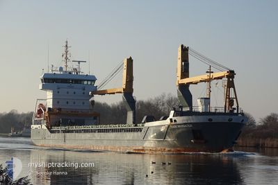
The vessel TRADE NAVIGATOR (IMO: 9631371, MMSI: 244650331) is a Cargo It's sailing under the flag of [NL] Netherlands.
In this page you can find informations about the vessels current position, last detected port calls, and current voyage information. If the vessels is not in coverage by AIS you will find the latest position.
The current position of TRADE NAVIGATOR is detected by our AIS receivers and we are not responsible for the reliability of the data. The last position was recorded while the vessel was in Coverage by the Ais receivers of our vessel tracking app.
The current draught of TRADE NAVIGATOR as reported by AIS is 7.7 meters
Weather
| Temperature | 11.1°C / 51.98°F |
|---|---|
| Wind Speed | 15 knots |
| Direction | 74° ENE |
| Pressure | 1016 hPa |
| Humidity | 85.4 % |
| Cloud Coverage | 11 % |
Featured Company
Last Port Calls
| Port | Arrival | Departure | Time In Port |
|---|---|---|---|
| 2024-05-15 04:07 | |||
| 2024-05-13 11:02 | 2024-05-13 17:56 | 6 h | |
| 2024-04-22 14:38 | 2024-05-01 17:38 | 9 d | |
| 2024-04-19 11:01 | 2024-04-21 11:55 | 2 d | |
| 2024-04-15 10:09 | 2024-04-16 11:17 | 1 d | |
| 2024-04-13 17:13 | 2024-04-14 13:12 | 19 h | |
| 2024-04-10 05:45 | 2024-04-11 08:38 | 1 d | |
| 2024-04-06 04:19 | 2024-04-06 18:12 | 13 h | |
| 2024-04-03 20:46 | 2024-04-04 20:27 | 23 h | |
| 2024-04-03 19:58 | 2024-04-03 20:26 | 27 m |
Most Visited Ports (Last year)
| Port | Arrivals | |
|---|---|---|
| 3 | ||
| 3 | ||
| 2 | ||
| 2 | ||
| 2 | ||
| 2 |
Last Trips
| Origin | Departure | Destination | Arrival | Distance | |
|---|---|---|---|---|---|
| 2024-05-13 19:56 | 2024-05-15 06:07 | 279.53 nm | |||
| 2024-05-01 20:38 | 2024-05-13 13:02 | 3227.03 nm | |||
| 2024-04-21 14:55 | 2024-04-22 17:38 | 329.94 nm | |||
| 2024-04-16 14:17 | 2024-04-19 14:01 | 511.48 nm | |||
| 2024-04-14 16:12 | 2024-04-15 13:09 | 246.29 nm | |||
| 2024-04-11 10:38 | 2024-04-13 20:13 | 687.75 nm | |||
| 2024-04-06 20:12 | 2024-04-10 07:45 | 1017.93 nm | |||
| 2024-04-04 22:27 | 2024-04-06 06:19 | 375.89 nm | |||
| 2024-04-03 22:26 | 2024-04-03 22:46 | 1.52 nm | |||
| 2024-04-02 17:21 | 2024-04-03 21:58 | 370.75 nm |
Events
| Time | Event | Details | Position / Dest | Info |
|---|---|---|---|---|
| 2024-05-15 04:15 | STOP Moving |
54.99885 / 11.88162
[DK] VORDINGBORG VESTHAVN
|
Speed: 0.3 kn Course: 123° |
|
| 2024-05-15 04:13 | Status Changed | Moored Under way using engine |
54.99897 / 11.88127
[DK] VORDINGBORG VESTHAVN
|
Speed: 0.5 kn Course: 123° |
| 2024-05-15 04:07 | PORT ARRIVAL |
|
54.99983 / 11.87875
[DK] VORDINGBORG VESTHAVN
|
Speed: 2 kn Course: 111° |
| 2024-05-14 22:17 | Change Sea Area | Danish part of the Kattegat Danish part of the Baltic Sea |
54.75438 / 10.87845
Kattegat
DKVOR
|
Speed: 11.6 kn Course: 358.1° |
| 2024-05-14 22:03 | ETA Changed | 2024/05/15 02:00 2024/05/15 01:00 |
54.70950 / 10.88178
DKVOR
|
Speed: 11.4 kn Course: 357° |
| 2024-05-14 20:44 | Change Sea Area | Danish part of the Baltic Sea German part of the Baltic Sea |
54.56498 / 10.59293
Baltic Sea
DKVOR
|
Speed: 10.5 kn Course: 66° |
| 2024-05-14 19:23 | Change Sea Area | German part of the Baltic Sea German part of the North Sea |
54.45935 / 10.26435
Baltic Sea
DKVOR
|
Speed: 10.2 kn Course: 40.7° |
| 2024-05-14 18:35 | START Moving | 1.32 nm, South West of STICKENHΟRN SPORT |
54.36583 / 10.14397
DKVOR
|
Speed: 3.1 kn Course: 103° |
| 2024-05-14 17:57 | STOP Moving | 1.4 nm, South West of STICKENHΟRN SPORT |
54.36632 / 10.13993
DKVOR
|
Speed: 0.3 kn Course: 105° |
| 2024-05-14 12:37 | ETA Changed | 2024/05/15 01:00 2024/05/15 08:00 |
54.18390 / 9.49068
DKVOR
|
Speed: 6.7 kn Course: 69.8° |