

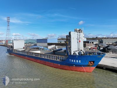
THEBE
General Cargo

Current Trip
| Trip Time | 3 days |
|---|---|
| Trip Distance | 714.83 nm |
| AVG Speed | 10.2 Knots |
| MAX Speed | 13.2 Knots |
| Draught | 4.2 m |
| AVG Wind | 13.9 knots |
| MAX Wind | 31 knots |
| MIN Temp | 5.2°C / 41.36°F |
| MAX Temp | 7.9°C / 46.22°F |
| Position Received | 4 m ago |
Current Position
| Longitude | --- |
|---|---|
| Latitude | --- |
| Status | Moored |
| Speed | |
| Course | 307° |
| Area | Norwegian Sea |
| Station | T-AIS |
| Position Received | 4 m ago |
Information
The current position of THEBE is in Norwegian Sea with coordinates 63.05515° / 7.66118° as reported on 2025-03-29 00:12 by AIS to our vessel tracker app. The vessel's current speed is 0 Knots and is currently inside the port of AVEROY.
The vessel THEBE (IMO: 9199696, MMSI: 304011026) is a General Cargo that was built in 2000 ( 25 years old ). It's sailing under the flag of [AG] Antigua Barbuda.
In this page you can find informations about the vessels current position, last detected port calls, and current voyage information. If the vessels is not in coverage by AIS you will find the latest position.
The current position of THEBE is detected by our AIS receivers and we are not responsible for the reliability of the data. The last position was recorded while the vessel was in Coverage by the Ais receivers of our vessel tracking app.
The current draught of THEBE as reported by AIS is 4.2 meters
Weather
| Temperature | 5.3°C / 41.54°F |
|---|---|
| Wind Speed | 6 knots |
| Direction | 133° SE |
| Pressure | 995.8 hPa |
| Humidity | 74.3 % |
| Cloud Coverage | 13 % |


Featured Company
Last Port Calls
| Port | Arrival | Departure | Time In Port |
|---|---|---|---|
| 2025-03-29 00:49 | |||
| 2025-03-24 22:49 | 2025-03-25 22:56 | 1 d | |
| 2025-03-23 16:28 | 2025-03-24 20:17 | 1 d | |
| 2025-03-20 19:42 | 2025-03-21 19:26 | 23 h | |
| 2025-03-18 02:52 | 2025-03-18 18:13 | 15 h | |
| 2025-03-17 17:52 | 2025-03-18 00:52 | 6 h | |
| 2025-03-14 18:50 | 2025-03-15 12:48 | 17 h | |
| 2025-03-13 00:33 | 2025-03-13 17:07 | 16 h | |
| 2025-03-12 17:08 | 2025-03-12 21:06 | 3 h | |
| 2025-03-12 04:13 | 2025-03-12 12:56 | 8 h |
Last Trips
| Origin | Departure | Destination | Arrival | Distance | |
|---|---|---|---|---|---|
| 2025-03-25 22:56 | 2025-03-29 00:49 | 714.83 nm | |||
| 2025-03-24 20:17 | 2025-03-24 22:49 | 24.58 nm | |||
| 2025-03-21 19:26 | 2025-03-23 16:28 | 397.76 nm | |||
| 2025-03-18 18:13 | 2025-03-20 19:42 | 503.89 nm | |||
| 2025-03-18 00:52 | 2025-03-18 02:52 | 18.29 nm | |||
| 2025-03-15 12:48 | 2025-03-17 17:52 | 446.88 nm | |||
| 2025-03-13 17:07 | 2025-03-14 18:50 | 247.33 nm | |||
| 2025-03-12 21:06 | 2025-03-13 00:33 | 32.46 nm | |||
| 2025-03-12 12:56 | 2025-03-12 17:08 | 39.19 nm | |||
| 2025-03-08 12:11 | 2025-03-12 04:13 | 795.35 nm |
Events
| Time | Event | Details | Position / Dest | Info |
|---|---|---|---|---|
| 2025-03-29 00:02 | Status Changed | Moored Under way using engine |
63.05519 / 7.66111
[NO] AVEROY
|
Speed: Course: 306° |
| 2025-03-28 23:51 | STOP Moving |
63.05518 / 7.66109
[NO] AVEROY
|
Speed: Course: 306° |
|
| 2025-03-28 23:49 | PORT ARRIVAL |
|
63.05520 / 7.66146
[NO] AVEROY
|
Speed: 0.7 kn Course: 278° |
| 2025-03-28 20:24 | ETA Changed | 2025/03/29 01:00 2025/03/29 00:30 |
63.21155 / 7.29384
NOKSU
|
Speed: 5.8 kn Course: 67.2° |
| 2025-03-28 03:19 | Change Sea Area | Norwegian part of the Norwegian Sea Norwegian part of the North Sea |
61.00290 / 4.27282
Norwegian Sea
NOKSU
|
Speed: 10.5 kn Course: 4.9° |
| 2025-03-27 21:03 | ETA Changed | 2025/03/29 00:30 2025/03/29 01:00 |
59.95872 / 4.54041
NOKSU
|
Speed: 10.6 kn Course: 355.6° |
| 2025-03-27 01:27 | Change Sea Area | Norwegian part of the North Sea Danish part of the North Sea |
57.00774 / 6.15542
North Sea
NOKSU
|
Speed: 9.8 kn Course: 354.3° |
| 2025-03-27 00:12 | Status Changed | Under way using engine Default |
56.80158 / 6.18553
NOKSU
|
Speed: 9.9 kn Course: 357° |
| 2025-03-27 00:12 | IN Coverage |
56.80158 / 6.18553
North Sea
NOKSU
|
Speed: 10 kn Course: 354° |
|
| 2025-03-26 23:08 | OUT of Coverage |
56.62741 / 6.20798
North Sea
NOKSU
|
Speed: 9.8 kn Course: 356.4° |