
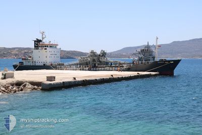
THANOS
Cement Carrier
Current Trip
| Time Travelled | 6 days |
|---|---|
| Remaining Time | --- |
| Distance Travelled | 137.71 nm |
| Remaining Distance | --- |
| AVG Speed | 8 Knots |
| MAX Speed | 10.4 Knots |
| AVG Wind | 16.1 knots |
| MAX Wind | 33 knots |
| MIN Temp | 10.1°C / 50.18°F |
| MAX Temp | 18.5°C / 65.3°F |
| Draught | 5.6 m |
| Position Received | 1 m ago |
Current Position
| Longitude | --- |
|---|---|
| Latitude | --- |
| Status | At anchor |
| Speed | 0.1 Knots |
| Course | 169° |
| Area | Mediterranean Sea - Eastern Basin |
| Station | T-AIS |
| Position Received | 1 m ago |
Info
Information
The current position of THANOS is in Mediterranean Sea - Eastern Basin with coordinates 36.40409° / 28.24213° as reported on 2026-01-11 01:48 by AIS to our vessel tracker app. The vessel's current speed is 0.1 Knots and is heading at the port of RHODES. The estimated time of arrival as calculated by MyShipTracking vessel tracking app is 2026-01-10 04:45 LT
The vessel THANOS (IMO: 9054731, MMSI: 209874000) is a Cement Carrier that was built in 1992 ( 34 years old ). It's sailing under the flag of [CY] Cyprus.
In this page you can find informations about the vessels current position, last detected port calls, and current voyage information. If the vessels is not in coverage by AIS you will find the latest position.
The current position of THANOS is detected by our AIS receivers and we are not responsible for the reliability of the data. The last position was recorded while the vessel was in Coverage by the Ais receivers of our vessel tracking app.
The current draught of THANOS as reported by AIS is 5.6 meters
Weather
| Temperature | 16.7°C / 62.06°F |
|---|---|
| Wind Speed | 19 knots |
| Direction | 211° SSW |
| Pressure | 1008.9 hPa |
| Humidity | 64.3 % |
| Cloud Coverage | 100 % |
Featured Company
Last Port Calls
| Port | Arrival | Departure | Time In Port |
|---|---|---|---|
| 2026-01-03 07:55 | 2026-01-04 17:10 | 1 d | |
| 2025-12-31 09:31 | 2026-01-02 08:27 | 1 d | |
| 2025-12-24 09:39 | |||
| 2025-12-20 10:30 | 2025-12-22 14:53 | 2 d | |
| 2025-12-18 16:01 | 2025-12-19 09:34 | 17 h | |
| 2025-12-13 13:45 | |||
| 2025-12-10 13:53 | 2025-12-11 14:24 | 1 d | |
| 2025-12-08 11:48 | 2025-12-10 13:24 | 2 d | |
| 2025-12-03 11:37 | 2025-12-04 13:29 | 1 d | |
| 2025-12-01 15:28 | 2025-12-02 10:45 | 19 h |
Last Trips
| Origin | Departure | Destination | Arrival | Distance | |
|---|---|---|---|---|---|
| 2026-01-02 08:27 | 2026-01-03 07:55 | 161.18 nm | |||
| 2025-12-24 09:39 | 2025-12-31 09:31 | 163.10 nm | |||
| 2025-12-19 09:34 | 2025-12-20 10:30 | 247.38 nm | |||
| 2025-12-13 13:45 | 2025-12-18 16:01 | 279.62 nm | |||
| 2025-12-10 13:24 | 2025-12-10 13:53 | 1.72 nm | |||
| 2025-12-04 13:29 | 2025-12-08 11:48 | 39.86 nm | |||
| 2025-12-02 10:45 | 2025-12-03 11:37 | 246.53 nm | |||
| 2025-11-30 15:10 | 2025-12-01 15:28 | 175.95 nm | |||
| 2025-11-27 16:46 | 2025-11-29 16:01 | 83.98 nm | |||
| 2025-11-21 10:50 | 2025-11-24 08:02 | 254.79 nm |
Events
| Time | Event | Details | Position / Dest | Info |
|---|---|---|---|---|
| 2026-01-11 00:50 | Status Changed | At anchor Default |
36.40405 / 28.24203
GRRHO
|
Speed: 0.8 kn Course: 184° |
| 2026-01-11 00:47 | Status Changed | Default At anchor |
36.40395 / 28.24210
GRRHO
|
Speed: 0.3 kn Course: 193° |
| 2026-01-10 21:53 | Status Changed | At anchor Default |
36.40397 / 28.24226
GRRHO
|
Speed: 0.2 kn Course: 192° |
| 2026-01-10 21:45 | Status Changed | Default At anchor |
36.40405 / 28.24231
GRRHO
|
Speed: 0.3 kn Course: 193° |
| 2026-01-10 18:41 | Status Changed | At anchor Default |
36.40366 / 28.24151
GRRHO
|
Speed: 0.1 kn Course: 124° |
| 2026-01-10 18:35 | Status Changed | Default At anchor |
36.40364 / 28.24138
GRRHO
|
Speed: 0.1 kn Course: 125° |
| 2026-01-10 11:02 | STOP Moving | 2.8 nm, South of RHODES |
36.40387 / 28.24159
GRRHO
|
Speed: 0.2 kn Course: 150° |
| 2026-01-10 10:53 | Status Changed | At anchor Under way using engine |
36.40278 / 28.24222
GRRHO
|
Speed: 1.1 kn Course: 188° |
| 2026-01-10 10:30 | START Moving | 1.63 nm, South of RHODES |
36.42484 / 28.24489
GRRHO
|
Speed: 5.1 kn Course: 190.4° |
| 2026-01-10 10:27 | Status Changed | Under way using engine At anchor |
36.42723 / 28.24526
GRRHO
|
Speed: 0.2 kn Course: 187° |