

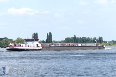
TERRA
Tanker

Current Trip
| Time Travelled | 1 day |
|---|---|
| Remaining Time | --- |
| Distance Travelled | 120.18 nm |
| Remaining Distance | --- |
| AVG Speed | 5.8 Knots |
| MAX Speed | 8.1 Knots |
| AVG Wind | 6.1 knots |
| MAX Wind | 10 knots |
| MIN Temp | 9.4°C / 48.92°F |
| MAX Temp | 13.7°C / 56.66°F |
| Draught | 1 m |
| Position Received | 3 h, 46 m ago |
Current Position
| Longitude | --- |
|---|---|
| Latitude | --- |
| Status | Under way using engine |
| Speed | |
| Course | --- |
| Area | North Sea |
| Station | T-AIS |
| Position Received | 3 h, 46 m ago |
Information
The current position of TERRA is in North Sea with coordinates 49.52002° / 8.43431° as reported on 2025-03-23 15:02 by AIS to our vessel tracker app. The vessel's current speed is 0 Knots
The vessel TERRA (MMSI: 211518200) is a Tanker It's sailing under the flag of [DE] Germany.
In this page you can find informations about the vessels current position, last detected port calls, and current voyage information. If the vessels is not in coverage by AIS you will find the latest position.
The current position of TERRA is detected by our AIS receivers and we are not responsible for the reliability of the data. The last position was recorded while the vessel was in Coverage by the Ais receivers of our vessel tracking app.
The current draught of TERRA as reported by AIS is 1 meters
Weather
| Temperature | 13.9°C / 57.02°F |
|---|---|
| Wind Speed | 6 knots |
| Direction | 272° W |
| Pressure | 1006.2 hPa |
| Humidity | 64.4 % |
| Cloud Coverage | 100 % |


Featured Company
Last Port Calls
| Port | Arrival | Departure | Time In Port |
|---|---|---|---|
| 2025-03-21 21:03 | 2025-03-22 06:42 | 9 h | |
| 2025-03-20 14:55 | 2025-03-21 02:34 | 11 h | |
| 2025-03-17 16:36 | 2025-03-17 19:11 | 2 h | |
| 2025-03-16 15:55 | 2025-03-16 17:09 | 1 h | |
| 2025-03-15 11:44 | 2025-03-15 22:20 | 10 h | |
| 2025-03-15 01:07 | 2025-03-15 10:52 | 9 h | |
| 2025-03-11 22:42 | 2025-03-12 07:11 | 8 h | |
| 2025-03-09 16:14 | 2025-03-10 12:21 | 20 h | |
| 2025-03-08 13:16 | 2025-03-08 13:54 | 38 m | |
| 2025-03-05 22:33 | 2025-03-06 11:02 | 12 h |
Last Trips
| Origin | Departure | Destination | Arrival | Distance | |
|---|---|---|---|---|---|
| 2025-03-21 02:34 | 2025-03-21 21:03 | 51.07 nm | |||
| 2025-03-17 19:11 | 2025-03-20 14:55 | 7.97 nm | |||
| 2025-03-16 17:09 | 2025-03-17 16:36 | 60.70 nm | |||
| 2025-03-15 22:20 | 2025-03-16 15:55 | 80.54 nm | |||
| 2025-03-15 10:52 | 2025-03-15 11:44 | 3.73 nm | |||
| 2025-03-12 07:11 | 2025-03-15 01:07 | 222.65 nm | |||
| 2025-03-10 12:21 | 2025-03-11 22:42 | 59.29 nm | |||
| 2025-03-08 13:54 | 2025-03-09 16:14 | 64.21 nm | |||
| 2025-03-06 11:02 | 2025-03-08 13:16 | 143.06 nm | |||
| 2025-03-02 20:38 | 2025-03-05 22:33 | 146.13 nm |
Events
| Time | Event | Details | Position / Dest | Info |
|---|---|---|---|---|
| 2025-03-23 15:02 | OUT of Coverage |
49.52002 / 8.43431
North Sea
LUDWIGSHAFEN BASF
|
Speed: Course: 150.4° |
|
| 2025-03-23 15:02 | STOP Moving | 1.87 nm, North of MANNHEIM |
49.52002 / 8.43431
LUDWIGSHAFEN BASF
|
Speed: Course: 511° |
| 2025-03-23 14:34 | START Moving | 2.75 nm, North of MANNHEIM |
49.53350 / 8.42547
LUDWIGSHAFEN BASF
|
Speed: 5.1 kn Course: 159.2° |
| 2025-03-23 14:33 | Status Changed | Under way using engine Moored |
49.53435 / 8.42497
LUDWIGSHAFEN BASF
|
Speed: Course: 511° |
| 2025-03-23 14:25 | Status Changed | Moored Under way using engine |
49.53554 / 8.42422
LUDWIGSHAFEN BASF
|
Speed: Course: 511° |
| 2025-03-23 14:08 | STOP Moving | 2.88 nm, North of MANNHEIM |
49.53554 / 8.42422
LUDWIGSHAFEN BASF
|
Speed: Course: 511° |
| 2025-03-23 14:02 | IN Coverage |
49.53838 / 8.42340
North Sea
LUDWIGSHAFEN BASF
|
Speed: 4.8 kn Course: 167.2° |
|
| 2025-03-23 11:13 | OUT of Coverage |
49.73891 / 8.45242
North Sea
LUDWIGSHAFEN BASF
|
Speed: 5.5 kn Course: 204.1° |
|
| 2025-03-23 10:30 | IN Coverage |
49.76653 / 8.42538
North Sea
LUDWIGSHAFEN BASF
|
Speed: 6.5 kn Course: 119.8° |
|
| 2025-03-23 09:29 | OUT of Coverage |
49.86322 / 8.36661
North Sea
LUDWIGSHAFEN BASF
|
Speed: 7 kn Course: 96.2° |