
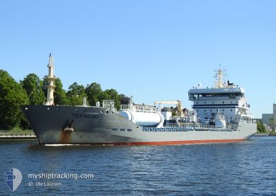
TERNVIND
Oil/Chemical Tanker
Current Trip
| Trip Time | 5 h, 33 mins |
|---|---|
| Trip Distance | 61.14 nm |
| AVG Speed | 9.8 Knots |
| MAX Speed | 13.2 Knots |
| Draught | 8.1 m |
| AVG Wind | 9.8 knots |
| MAX Wind | 11 knots |
| MIN Temp | 2.9°C / 37.22°F |
| MAX Temp | 3.5°C / 38.3°F |
| Position Received | 1 d ago |
Current Position
| Longitude | --- |
|---|---|
| Latitude | --- |
| Status | Under way using engine |
| Speed | 0.2 Knots |
| Course | 41° |
| Area | Skaggerak |
| Station | T-AIS |
| Position Received | 1 d ago |
Info
Information
The current position of TERNVIND is in Skaggerak with coordinates 58.35403° / 11.43748° as reported on 2026-03-05 19:57 by AIS to our vessel tracker app. The vessel's current speed is 0.2 Knots and is currently inside the port of BROFJORDEN.
The vessel TERNVIND (IMO: 9425356, MMSI: 219554000) is a Oil/Chemical Tanker that was built in 2008 ( 18 years old ). It's sailing under the flag of [DK] Denmark.
In this page you can find informations about the vessels current position, last detected port calls, and current voyage information. If the vessels is not in coverage by AIS you will find the latest position.
The current position of TERNVIND is detected by our AIS receivers and we are not responsible for the reliability of the data. The last position was recorded while the vessel was in Coverage by the Ais receivers of our vessel tracking app.
The current draught of TERNVIND as reported by AIS is 8.1 meters
Weather
| Temperature | 4.3°C / 39.74°F |
|---|---|
| Wind Speed | 5 knots |
| Direction | 80° E |
| Pressure | 1027.7 hPa |
| Humidity | 83.8 % |
| Cloud Coverage | 97 % |
Featured Company
Last Port Calls
| Port | Arrival | Departure | Time In Port |
|---|---|---|---|
| 2026-03-05 20:57 | |||
| 2026-03-03 08:03 | 2026-03-05 15:24 | 2 d | |
| 2026-02-26 10:19 | 2026-02-27 11:24 | 1 d | |
| 2026-02-22 23:45 | 2026-02-23 22:05 | 22 h | |
| 2026-02-19 02:56 | 2026-02-19 23:14 | 20 h | |
| 2026-02-16 16:58 | 2026-02-17 21:35 | 1 d | |
| 2026-02-15 18:44 | 2026-02-16 06:27 | 11 h | |
| 2026-02-13 07:27 | 2026-02-13 16:37 | 9 h | |
| 2026-02-12 01:51 | 2026-02-13 06:08 | 1 d | |
| 2026-02-05 23:17 | 2026-02-07 22:03 | 1 d |
Most Visited Ports (Last year)
| Port | Arrivals | |
|---|---|---|
| 19 | ||
| 8 | ||
| 8 | ||
| 8 | ||
| 5 | ||
| 4 |
Last Trips
| Origin | Departure | Destination | Arrival | Distance | |
|---|---|---|---|---|---|
| 2026-03-05 15:24 | 2026-03-05 20:57 | 61.14 nm | |||
| 2026-02-27 11:24 | 2026-03-03 08:03 | 1045.72 nm | |||
| 2026-02-23 22:05 | 2026-02-26 10:19 | 335.64 nm | |||
| 2026-02-19 23:14 | 2026-02-22 23:45 | 852.49 nm | |||
| 2026-02-17 21:35 | 2026-02-19 02:56 | 61.74 nm | |||
| 2026-02-16 06:27 | 2026-02-16 16:58 | 138.06 nm | |||
| 2026-02-13 16:37 | 2026-02-15 18:44 | 608.71 nm | |||
| 2026-02-13 06:08 | 2026-02-13 07:27 | 11.90 nm | |||
| 2026-02-07 22:03 | 2026-02-12 01:51 | 698.71 nm | |||
| 2026-02-02 15:16 | 2026-02-05 23:17 | 507.60 nm |
Events
| Time | Event | Details | Position / Dest | Info |
|---|---|---|---|---|
| 2026-03-05 20:02 | Status Changed | Default Under way using engine |
58.35406 / 11.43741
[SE] BROFJORDEN
|
Speed: 0.2 kn Course: 41° |
| 2026-03-05 19:57 | OUT of Coverage |
58.35403 / 11.43748
Skaggerak
[SE] BROFJORDEN
|
Speed: 0.2 kn Course: 249.3° |
|
| 2026-03-05 19:57 | PORT ARRIVAL |
|
58.35403 / 11.43748
[SE] BROFJORDEN
|
Speed: 1.4 kn Course: 40° |
| 2026-03-05 19:44 | STOP Moving | --- |
58.35606 / 11.44079
SEGOT
|
Speed: 0.3 kn Course: 71° |
| 2026-03-05 16:41 | Change Sea Area | Swedish part of the Skaggerak Swedish part of the Kattegat |
57.87756 / 11.30948
Skaggerak
|
Speed: 13 kn Course: 352.7° |
| 2026-03-05 14:24 | PORT DEPARTURE |
|
57.67987 / 11.81144
SEGOT
|
Speed: 12 kn Course: 247° |
| 2026-03-05 14:09 | START Moving |
57.68983 / 11.86891
[SE] GOTEBORG
|
Speed: 3.2 kn Course: 208° |
|
| 2026-03-05 13:43 | Status Changed | Under way using engine Moored |
57.69148 / 11.87084
[SE] GOTEBORG
|
Speed: Course: 197° |
| 2026-03-05 12:15 | Status Changed | Moored Default |
57.69148 / 11.87084
[SE] GOTEBORG
|
Speed: Course: 197° |
| 2026-03-05 12:12 | Status Changed | Default Moored |
57.69150 / 11.87086
[SE] GOTEBORG
|
Speed: Course: 197° |