
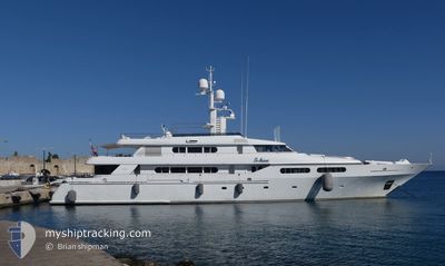
TE MANU
Yacht
Current Trip
| Trip Time | 2 days |
|---|---|
| Trip Distance | 117.40 nm |
| AVG Speed | 10 Knots |
| MAX Speed | 12.6 Knots |
| Draught | 3.1 m |
| AVG Wind | 16.5 knots |
| MAX Wind | 20.8 knots |
| MIN Temp | 26.2°C / 79.16°F |
| MAX Temp | 27.4°C / 81.32°F |
| Position Received | 5 m ago |
Current Position
| Longitude | --- |
|---|---|
| Latitude | --- |
| Status | At anchor |
| Speed | 0.3 Knots |
| Course | 87° |
| Area | Caribbean Sea |
| Station | T-AIS |
| Position Received | 5 m ago |
Info
Information
The current position of TE MANU is in Caribbean Sea with coordinates 18.31744° / -64.62121° as reported on 2025-12-12 13:42 by AIS to our vessel tracker app. The vessel's current speed is 0.3 Knots and is currently inside the port of NORMAN ISLAND.
The vessel TE MANU (IMO: 1006269, MMSI: 319315000) is a Yacht that was built in 1998 ( 27 years old ). It's sailing under the flag of [KY] Cayman Is.
In this page you can find informations about the vessels current position, last detected port calls, and current voyage information. If the vessels is not in coverage by AIS you will find the latest position.
The current position of TE MANU is detected by our AIS receivers and we are not responsible for the reliability of the data. The last position was recorded while the vessel was in Coverage by the Ais receivers of our vessel tracking app.
The current draught of TE MANU as reported by AIS is 3.1 meters
Weather
| Temperature | 27.1°C / 80.78°F |
|---|---|
| Wind Speed | 19 knots |
| Direction | 100° E |
| Pressure | 1017 hPa |
| Humidity | 72.6 % |
| Cloud Coverage | 6 % |
Featured Company
Last Port Calls
| Port | Arrival | Departure | Time In Port |
|---|---|---|---|
| 2025-12-12 08:29 | |||
| 2025-12-01 09:34 | 2025-12-09 16:05 | 8 d | |
| 2025-11-16 12:18 | 2025-11-20 13:13 | 4 d | |
| 2025-11-05 11:56 | 2025-11-13 22:13 | 8 d | |
| 2025-10-23 06:45 | 2025-10-23 17:54 | 11 h | |
| 2025-10-22 01:48 | |||
| 2025-10-19 11:27 | 2025-10-19 20:23 | 8 h | |
| 2025-10-17 07:50 | 2025-10-17 23:03 | 15 h | |
| 2025-10-15 07:59 | 2025-10-16 21:58 | 1 d | |
| 2025-10-14 11:14 | 2025-10-14 22:15 | 11 h |
Last Trips
| Origin | Departure | Destination | Arrival | Distance | |
|---|---|---|---|---|---|
| 2025-12-09 16:05 | 2025-12-12 08:29 | 117.40 nm | |||
| 2025-11-20 13:13 | 2025-12-01 09:34 | 3234.34 nm | |||
| 2025-11-13 22:13 | 2025-11-16 12:18 | 672.17 nm | |||
| 2025-10-22 01:48 | 2025-10-23 06:45 | 124.83 nm | |||
| 2025-10-17 23:03 | 2025-10-19 11:27 | 351.05 nm | |||
| 2025-10-16 21:58 | 2025-10-17 07:50 | 98.39 nm | |||
| 2025-10-14 22:15 | 2025-10-15 07:59 | 95.07 nm | |||
| 2025-10-13 18:12 | 2025-10-14 11:14 | 68.27 nm | |||
| 2025-10-12 10:00 | 2025-10-13 10:57 | 181.61 nm | |||
| 2025-10-07 10:11 | 2025-10-09 08:59 | 344.55 nm |
Events
| Time | Event | Details | Position / Dest | Info |
|---|---|---|---|---|
| 2025-12-12 12:39 | Status Changed | At anchor Under way using engine |
18.31722 / -64.62120
[VG] NORMAN ISLAND
|
Speed: 0.5 kn Course: 54° |
| 2025-12-12 12:31 | STOP Moving |
18.31731 / -64.62066
[VG] NORMAN ISLAND
|
Speed: 0.3 kn Course: 98° |
|
| 2025-12-12 12:29 | PORT ARRIVAL |
|
18.31756 / -64.62127
[VG] NORMAN ISLAND
|
Speed: 1.1 kn Course: 103° |
| 2025-12-12 11:08 | Status Changed | Under way using engine At anchor |
18.45316 / -64.54262
VG EIQNTE
|
Speed: 3.7 kn Course: 69° |
| 2025-12-12 11:07 | START Moving | 0.7 nm, North West of BEEF ISLAND |
18.45251 / -64.54415
VG EIQNTE
|
Speed: 3.7 kn Course: 69° |
| 2025-12-12 07:37 | IN Coverage |
18.44890 / -64.54596
Caribbean Sea
|
Speed: 0.3 kn Course: 117.4° |
|
| 2025-12-12 05:58 | OUT of Coverage |
18.44866 / -64.54591
Caribbean Sea
|
Speed: 0.2 kn Course: 26.4° |
|
| 2025-12-12 00:56 | Destination Changed | VG EIQNTE VG RAD |
18.44924 / -64.54579
VG EIQNTE
|
Speed: 0.1 kn Course: 130° |
| 2025-12-11 08:16 | IN Coverage |
18.44903 / -64.54588
Caribbean Sea
|
Speed: 0.1 kn Course: 9.4° |
|
| 2025-12-11 05:49 | OUT of Coverage |
18.44918 / -64.54580
Caribbean Sea
|
Speed: 0.1 kn Course: 45.9° |