
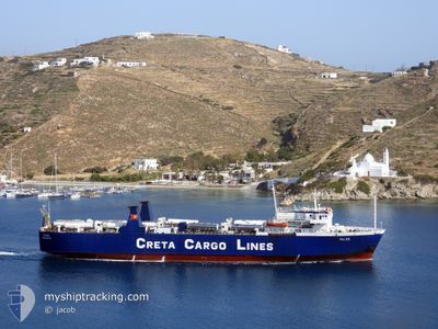
TALOS
Ro-Ro Cargo
Current Trip
PIR-KO-RODO
| Time Travelled | 1 h, 45 mins |
|---|---|
| Remaining Time | --- |
| Distance Travelled | 18.20 nm |
| Remaining Distance | --- |
| AVG Speed | 14.6 Knots |
| MAX Speed | 15 Knots |
| AVG Wind | 18.3 knots |
| MAX Wind | 20 knots |
| MIN Temp | 13.3°C / 55.94°F |
| MAX Temp | 16.4°C / 61.52°F |
| Draught | 4.2 m |
| Position Received | 15 m ago |
Current Position
| Longitude | --- |
|---|---|
| Latitude | --- |
| Status | Under way using engine |
| Speed | 14.6 Knots |
| Course | 272° |
| Area | Aegean Sea |
| Station | T-AIS |
| Position Received | 15 m ago |
Info
Information
The current position of TALOS is in Aegean Sea with coordinates 36.84984° / 26.87318° as reported on 2025-12-11 02:08 by AIS to our vessel tracker app. The vessel's current speed is 14.6 Knots
The vessel TALOS (IMO: 7043843, MMSI: 239786000) is a Ro-Ro Cargo that was built in 1971 ( 54 years old ). It's sailing under the flag of [GR] Greece.
In this page you can find informations about the vessels current position, last detected port calls, and current voyage information. If the vessels is not in coverage by AIS you will find the latest position.
The current position of TALOS is detected by our AIS receivers and we are not responsible for the reliability of the data. The last position was recorded while the vessel was in Coverage by the Ais receivers of our vessel tracking app.
The current draught of TALOS as reported by AIS is 4.2 meters
Weather
| Temperature | 16.9°C / 62.42°F |
|---|---|
| Wind Speed | 22 knots |
| Direction | 348° NNW |
| Pressure | 1016.7 hPa |
| Humidity | 60.3 % |
| Cloud Coverage | 8 % |
Featured Company
Last Port Calls
| Port | Arrival | Departure | Time In Port |
|---|---|---|---|
| 2025-12-11 01:53 | 2025-12-11 02:39 | 45 m | |
| 2025-12-10 14:39 | 2025-12-10 21:28 | 6 h | |
| 2025-12-10 09:21 | 2025-12-10 10:23 | 1 h | |
| 2025-12-09 08:15 | 2025-12-09 17:34 | 9 h | |
| 2025-12-08 18:58 | 2025-12-08 20:26 | 1 h | |
| 2025-12-08 09:55 | 2025-12-08 14:17 | 4 h | |
| 2025-12-08 02:58 | 2025-12-08 03:36 | 37 m | |
| 2025-12-07 11:08 | 2025-12-07 22:09 | 11 h | |
| 2025-12-07 05:54 | 2025-12-07 05:57 | 2 m | |
| 2025-12-06 17:43 | 2025-12-06 21:08 | 3 h |
Last Trips
| Origin | Departure | Destination | Arrival | Distance | |
|---|---|---|---|---|---|
| 2025-12-10 21:28 | 2025-12-11 01:53 | 61.86 nm | |||
| 2025-12-10 10:23 | 2025-12-10 14:39 | 59.60 nm | |||
| 2025-12-09 17:34 | 2025-12-10 09:21 | 228.26 nm | |||
| 2025-12-08 20:26 | 2025-12-09 08:15 | 169.07 nm | |||
| 2025-12-08 14:17 | 2025-12-08 18:58 | 70.89 nm | |||
| 2025-12-08 03:36 | 2025-12-08 09:55 | 91.67 nm | |||
| 2025-12-07 22:09 | 2025-12-08 02:58 | 71.09 nm | |||
| 2025-12-07 05:57 | 2025-12-07 11:08 | 74.12 nm | |||
| 2025-12-06 21:08 | 2025-12-07 05:54 | 95.68 nm | |||
| 2025-12-06 13:12 | 2025-12-06 17:43 | 69.83 nm |
Events
| Time | Event | Details | Position / Dest | Info |
|---|---|---|---|---|
| 2025-12-11 01:59 | Change Sea Area | Greek part of the Aegean Sea Turkish part of the Aegean Sea |
36.84819 / 26.91969
Aegean Sea
|
Speed: 14.4 kn Course: 272° |
| 2025-12-11 01:58 | Status Changed | Under way using engine Default |
36.84813 / 26.92262
PIR-KO-RODO
|
Speed: 15 kn Course: 248° |
| 2025-12-11 01:58 | IN Coverage |
36.84819 / 26.91969
Aegean Sea
|
Speed: 14.4 kn Course: 272° |
|
| 2025-12-11 00:39 | PORT DEPARTURE |
|
36.93667 / 27.25500
PIR-KO-RODO
|
Speed: 0.6 kn Course: -1° |
| 2025-12-10 23:53 | PORT ARRIVAL |
|
36.89834 / 27.29667
[GR] KOS
|
Speed: 14 kn Course: 276° |
| 2025-12-10 23:10 | Status Changed | Default Under way using engine |
36.77739 / 27.34821
PIR-KO-RODO
|
Speed: 14 kn Course: 7.4° |
| 2025-12-10 22:49 | Change Sea Area | Turkish part of the Aegean Sea Greek part of the Mediterranean Sea - Eastern Basin |
36.69756 / 27.33826
Aegean Sea
|
Speed: 14 kn Course: 7.4° |
| 2025-12-10 22:49 | OUT of Coverage |
36.69756 / 27.33826
Aegean Sea
|
Speed: 14 kn Course: 7.4° |
|
| 2025-12-10 22:48 | Status Changed | Under way using engine Default |
36.69060 / 27.33706
PIR-KO-RODO
|
Speed: 14 kn Course: 299° |
| 2025-12-10 22:36 | IN Coverage |
36.69756 / 27.33826
Aegean Sea
|
Speed: 14 kn Course: 7.4° |