

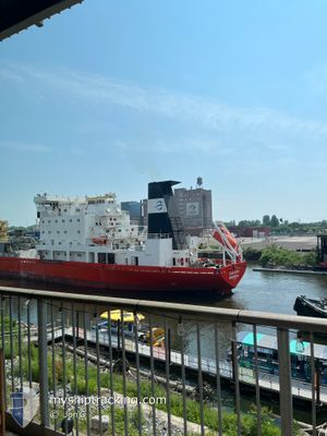
SUNNANVIK
Cement Carrier

Current Trip
| Time Travelled | 23 h, 25 mins |
|---|---|
| Remaining Time | 23 mins |
| Distance Travelled | 89.60 nm |
| Remaining Distance | 70.92 nm |
| AVG Speed | 7.3 Knots |
| MAX Speed | 11.8 Knots |
| AVG Wind | 5.9 knots |
| MAX Wind | 15.7 knots |
| MIN Temp | -3.6°C / 25.52°F |
| MAX Temp | 2.2°C / 35.96°F |
| Draught | 6.2 m |
| Position Received | 7 h, 56 m ago |
Current Position
| Longitude | --- |
|---|---|
| Latitude | --- |
| Status | Under way using engine |
| Speed | 7.9 Knots |
| Course | 236.1° |
| Area | --- |
| Station | T-AIS |
| Position Received | 7 h, 56 m ago |
Information
The current position of SUNNANVIK is in --- with coordinates 42.24281° / -80.56239° as reported on 2025-03-24 01:54 by AIS to our vessel tracker app. The vessel's current speed is 7.9 Knots and is heading at the port of CLEVELAND. The estimated time of arrival as calculated by MyShipTracking vessel tracking app is 2025-03-24 06:13 LT
The vessel SUNNANVIK (IMO: 7633375, MMSI: 316018180) is a Cement Carrier that was built in 1978 ( 47 years old ). It's sailing under the flag of [CA] Canada.
In this page you can find informations about the vessels current position, last detected port calls, and current voyage information. If the vessels is not in coverage by AIS you will find the latest position.
The current position of SUNNANVIK is detected by our AIS receivers and we are not responsible for the reliability of the data. The last position was recorded while the vessel was in Coverage by the Ais receivers of our vessel tracking app.
The current draught of SUNNANVIK as reported by AIS is 6.2 meters
Weather
| Temperature | 2°C / 35.6°F |
|---|---|
| Wind Speed | 13 knots |
| Direction | 116° ESE |
| Pressure | 1011.9 hPa |
| Humidity | 76.1 % |
| Cloud Coverage | 100 % |


Featured Company
Last Port Calls
| Port | Arrival | Departure | Time In Port |
|---|---|---|---|
| 2025-03-23 05:05 | 2025-03-23 06:25 | 1 h | |
| 2025-03-21 05:30 | 2025-03-21 20:43 | 15 h | |
| 2025-03-18 07:52 | 2025-03-18 21:23 | 13 h | |
| 2025-03-15 08:15 | 2025-03-16 15:35 | 1 d | |
| 2025-03-13 19:41 | |||
| 2025-03-12 22:23 | 2025-03-12 22:30 | 7 m | |
| 2025-03-09 22:12 | 2025-03-10 18:01 | 19 h | |
| 2025-03-07 19:03 |
Most Visited Ports (Last year)
| Port | Arrivals | |
|---|---|---|
| 57 | ||
| 50 | ||
| 19 | ||
| 18 | ||
| 16 | ||
| 2 |
Last Trips
| Origin | Departure | Destination | Arrival | Distance | |
|---|---|---|---|---|---|
| 2025-03-21 20:43 | 2025-03-23 05:05 | 215.76 nm | |||
| 2025-03-18 21:23 | 2025-03-21 05:30 | 213.99 nm | |||
| 2025-03-16 15:35 | 2025-03-18 07:52 | 196.40 nm | |||
| 2025-03-12 22:30 | 2025-03-13 19:41 | 30.20 nm | |||
| 2025-03-10 18:01 | 2025-03-12 22:23 | 139.00 nm | |||
| 2025-03-07 19:03 | 2025-03-09 22:12 | 44.77 nm |
Events
| Time | Event | Details | Position / Dest | Info |
|---|---|---|---|---|
| 2025-03-24 01:54 | OUT of Coverage |
42.24281 / -80.56239
CLEVELAND
|
Speed: 7.9 kn Course: 236.1° |
|
| 2025-03-23 17:12 | START Moving | 0.77 nm, North of PORT COLBORNE |
42.89415 / -79.24729
CLEVELAND
|
Speed: 3.2 kn Course: 193° |
| 2025-03-23 16:52 | STOP Moving | 1.09 nm, North of PORT COLBORNE |
42.89948 / -79.24592
CLEVELAND
|
Speed: 0.2 kn Course: 192° |
| 2025-03-23 14:34 | START Moving | 5.73 nm, South East of DALHOUSIE |
43.11870 / -79.19495
CLEVELAND
|
Speed: 3.1 kn Course: 191° |
| 2025-03-23 12:46 | STOP Moving | 4.98 nm, South East of DALHOUSIE |
43.13636 / -79.19210
CLEVELAND
|
Speed: Course: 184° |
| 2025-03-23 12:17 | START Moving | 4.35 nm, South of PORT WELLER |
43.14956 / -79.19279
CLEVELAND
|
Speed: 3.6 kn Course: 175° |
| 2025-03-23 11:57 | STOP Moving | 3.99 nm, South of PORT WELLER |
43.15546 / -79.19361
CLEVELAND
|
Speed: Course: 176° |
| 2025-03-23 11:10 | START Moving | 1.89 nm, South of PORT WELLER |
43.19027 / -79.20081
CLEVELAND
|
Speed: 3.1 kn Course: 155° |
| 2025-03-23 10:43 | STOP Moving | 1.71 nm, South of PORT WELLER |
43.19310 / -79.20249
CLEVELAND
|
Speed: 0.1 kn Course: 158° |
| 2025-03-23 10:25 | PORT DEPARTURE |
|
43.20477 / -79.20857
CLEVELAND
|
Speed: 4.4 kn Course: 164° |