
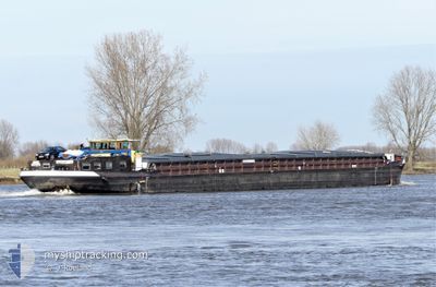
STYX
Cargo
Current Trip
| Trip Time | --- |
|---|---|
| Trip Distance | --- |
| AVG Speed | --- |
| MAX Speed | --- |
| Draught | --- |
| AVG Wind | --- |
| MAX Wind | --- |
| MIN Temp | --- |
| MAX Temp | --- |
| Position Received | 1 d ago |
Current Position
| Longitude | --- |
|---|---|
| Latitude | --- |
| Status | Under way using engine |
| Speed | |
| Course | --- |
| Area | North Sea |
| Station | T-AIS |
| Position Received | 1 d ago |
Info
Information
The current position of STYX is in North Sea with coordinates 52.24616° / 6.18530° as reported on 2025-12-11 09:51 by AIS to our vessel tracker app. The vessel's current speed is 0 Knots and is currently inside the port of DEVENTER.
The vessel STYX (MMSI: 244690637) is a Cargo It's sailing under the flag of [NL] Netherlands.
In this page you can find informations about the vessels current position, last detected port calls, and current voyage information. If the vessels is not in coverage by AIS you will find the latest position.
The current position of STYX is detected by our AIS receivers and we are not responsible for the reliability of the data. The last position was recorded while the vessel was in Coverage by the Ais receivers of our vessel tracking app.
The current draught of STYX as reported by AIS is 2.5 meters
Weather
| Temperature | 7.4°C / 45.32°F |
|---|---|
| Wind Speed | 9 knots |
| Direction | 221° SW |
| Pressure | 1022.9 hPa |
| Humidity | 93.8 % |
| Cloud Coverage | 45 % |
Featured Company
Last Port Calls
| Port | Arrival | Departure | Time In Port |
|---|---|---|---|
| 2025-12-07 13:08 | 2025-12-08 08:22 | 19 h | |
| 2025-12-04 18:32 | 2025-12-05 07:23 | 12 h | |
| 2025-11-01 12:28 | 2025-11-01 12:49 | 20 m | |
| 2025-10-29 16:35 | 2025-10-29 17:07 | 32 m | |
| 2025-10-26 12:06 | 2025-10-29 15:15 | 3 d | |
| 2025-10-25 11:23 | 2025-10-26 09:41 | 23 h | |
| 2025-10-24 16:43 | 2025-10-25 10:41 | 17 h | |
| 2025-10-24 13:32 | 2025-10-24 14:10 | 38 m | |
| 2025-10-24 13:10 | 2025-10-24 13:22 | 11 m | |
| 2025-10-13 12:15 | 2025-10-24 10:57 | 10 d |
Last Trips
| Origin | Departure | Destination | Arrival | Distance | |
|---|---|---|---|---|---|
| 2025-12-05 07:23 | 2025-12-07 13:08 | 141.44 nm | |||
| 2025-11-01 12:49 | 2025-12-04 18:32 | 56.08 nm | |||
| 2025-10-29 17:07 | 2025-11-01 12:28 | 94.01 nm | |||
| 2025-10-29 15:15 | 2025-10-29 16:35 | 10.20 nm | |||
| 2025-10-26 09:41 | 2025-10-26 12:06 | 19.65 nm | |||
| 2025-10-25 10:41 | 2025-10-25 11:23 | 4.38 nm | |||
| 2025-10-24 14:10 | 2025-10-24 16:43 | 23.03 nm | |||
| 2025-10-24 13:22 | 2025-10-24 13:32 | 0.95 nm | |||
| 2025-10-24 10:57 | 2025-10-24 13:10 | 10.28 nm | |||
| 2025-10-10 16:32 | 2025-10-13 12:15 | 127.76 nm |
Events
| Time | Event | Details | Position / Dest | Info |
|---|---|---|---|---|
| 2025-12-11 09:51 | OUT of Coverage |
52.24616 / 6.18530
North Sea
[NL] DEVENTER
|
Speed: Course: 511° |
|
| 2025-12-11 09:51 | IN Coverage |
52.24616 / 6.18530
North Sea
[NL] DEVENTER
|
Speed: Course: 511° |
|
| 2025-12-08 09:53 | OUT of Coverage |
52.23572 / 6.16105
North Sea
|
Speed: 5.5 kn Course: 350.5° |
|
| 2025-12-08 07:22 | PORT DEPARTURE |
|
52.02365 / 6.13216
DESLE03912DOCKX01232
|
Speed: 7.8 kn Course: 7.9° |
| 2025-12-08 07:18 | START Moving |
52.01594 / 6.12767
[NL] DOESBURG
|
Speed: 5.7 kn Course: 1.7° |
|
| 2025-12-07 12:08 | STOP Moving |
52.01389 / 6.12808
[NL] DOESBURG
|
Speed: 0.1 kn Course: 511° |
|
| 2025-12-07 12:08 | PORT ARRIVAL |
|
52.01390 / 6.12799
[NL] DOESBURG
|
Speed: 0.9 kn Course: 511° |
| 2025-12-07 09:08 | IN Coverage |
51.80467 / 6.30525
North Sea
|
Speed: 10.8 kn Course: 312.3° |
|
| 2025-12-07 07:50 | OUT of Coverage |
51.66168 / 6.51455
North Sea
|
Speed: 11.2 kn Course: 264.8° |
|
| 2025-12-07 07:22 | START Moving | 1.29 nm, South of WESEL |
51.63138 / 6.60910
DESLE03912DOCKX01232
|
Speed: 6.9 kn Course: 321.4° |