
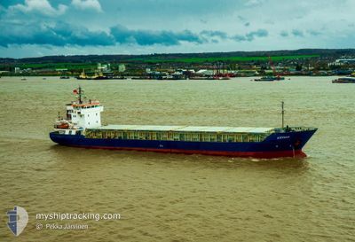
STEFANY
General Cargo
Current Trip
| Time Travelled | 2 days |
|---|---|
| Remaining Time | 13 h, 4 mins |
| Distance Travelled | 673.78 nm |
| Remaining Distance | 139.43 nm |
| AVG Speed | 10 Knots |
| MAX Speed | 11 Knots |
| AVG Wind | 6.3 knots |
| MAX Wind | 16 knots |
| MIN Temp | 12.9°C / 55.22°F |
| MAX Temp | 19°C / 66.2°F |
| Draught | 3.4 m |
| Position Received | 8 m ago |
Current Position
| Longitude | 15.54368° |
|---|---|
| Latitude | 38.79047° |
| Status | Under way using engine |
| Speed | 10.2 Knots |
| Course | 319.3° |
| Area | Tyrrhenian Sea |
| Station | T-AIS |
| Position Received | 8 m ago |
Info
Information
The current position of STEFANY is in Tyrrhenian Sea with coordinates 38.79047° / 15.54368° as reported on 2024-05-02 05:19 by AIS to our vessel tracker app. The vessel's current speed is 10.2 Knots and is heading at the port of NAPOLI. The estimated time of arrival as calculated by MyShipTracking vessel tracking app is 2024-05-02 18:32 LT
The vessel STEFANY (IMO: 9006394, MMSI: 374608000) is a General Cargo that was built in 1995 ( 29 years old ). It's sailing under the flag of [PA] Panama.
In this page you can find informations about the vessels current position, last detected port calls, and current voyage information. If the vessels is not in coverage by AIS you will find the latest position.
The current position of STEFANY is detected by our AIS receivers and we are not responsible for the reliability of the data. The last position was recorded while the vessel was in Coverage by the Ais receivers of our vessel tracking app.
The current draught of STEFANY as reported by AIS is 3.4 meters
Weather
| Temperature | 16.2°C / 61.16°F |
|---|---|
| Wind Speed | 5 knots |
| Direction | 206° SSW |
| Pressure | 1014.1 hPa |
| Humidity | 82 % |
| Cloud Coverage | 16 % |
Featured Company
Last Port Calls
| Port | Arrival | Departure | Time In Port |
|---|---|---|---|
| 2024-04-26 14:09 | 2024-04-29 10:16 | 2 d | |
| 2024-03-25 07:03 | 2024-04-02 21:37 | 8 d | |
| 2024-03-03 08:30 | 2024-03-08 00:22 | 4 d |
Most Visited Ports (Last year)
| Port | Arrivals | |
|---|---|---|
| 3 | ||
| 3 | ||
| 2 | ||
| 2 | ||
| 2 | ||
| 1 |
Last Trips
| Origin | Departure | Destination | Arrival | Distance | |
|---|---|---|---|---|---|
| 2024-04-02 22:37 | 2024-04-26 16:09 | 3233.53 nm | |||
| 2024-03-08 03:22 | 2024-03-25 07:03 | 3072.43 nm | |||
| 2024-02-29 17:16 | 2024-03-03 11:30 | 302.17 nm |
Events
| Time | Event | Details | Position / Dest | Info |
|---|---|---|---|---|
| 2024-05-02 05:24 | Status Changed | Default Under way using engine |
38.80220 / 15.53349
ITNAP
|
Speed: 10.2 kn Course: 319.3° |
| 2024-05-02 02:05 | Change Sea Area | Italian part of the Tyrrhenian Sea Italian part of the Ionian Sea |
38.25400 / 15.66840
Tyrrhenian Sea
ITNAP
|
Speed: 9.1 kn Course: 63.3° |
| 2024-05-01 20:27 | Status Changed | Under way using engine Default |
37.89195 / 16.19356
ITNAP
|
Speed: 10.6 kn Course: 237° |
| 2024-05-01 20:22 | IN Coverage |
37.89195 / 16.19356
Ionian Sea
ITNAP
|
Speed: 10.5 kn Course: 237.5° |
|
| 2024-05-01 18:46 | Status Changed | Default Under way using engine |
38.04579 / 16.50230
ITNAP
|
Speed: 10.2 kn Course: 239° |
| 2024-05-01 18:37 | OUT of Coverage |
38.05866 / 16.52978
Ionian Sea
ITNAP
|
Speed: 10.2 kn Course: 239° |
|
| 2024-05-01 17:30 | Status Changed | Under way using engine Default |
38.16908 / 16.72506
ITNAP
|
Speed: 9.7 kn Course: 231° |
| 2024-05-01 17:27 | Status Changed | Default Under way using engine |
38.17530 / 16.73502
ITNAP
|
Speed: 9.7 kn Course: 232.6° |
| 2024-05-01 17:10 | Status Changed | Under way using engine Default |
38.20259 / 16.77847
ITNAP
|
Speed: 9.3 kn Course: 234° |
| 2024-05-01 17:10 | IN Coverage |
38.20259 / 16.77847
Ionian Sea
ITNAP
|
Speed: 9.7 kn Course: 231.5° |