

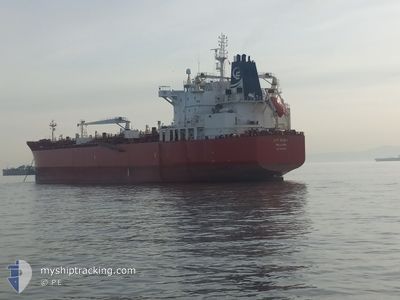
SEA QUEST
Oil/Chemical Tanker

Current Trip
| Time Travelled | 3 days |
|---|---|
| Remaining Time | --- |
| Distance Travelled | 786.43 nm |
| Remaining Distance | --- |
| AVG Speed | 11.6 Knots |
| MAX Speed | 13.8 Knots |
| AVG Wind | 7 knots |
| MAX Wind | 14.3 knots |
| MIN Temp | 24.4°C / 75.92°F |
| MAX Temp | 27.8°C / 82.04°F |
| Draught | 11.7 m |
| Position Received | 1 m ago |
Current Position
| Longitude | --- |
|---|---|
| Latitude | --- |
| Status | At anchor |
| Speed | |
| Course | 228° |
| Area | Persian Gulf |
| Station | T-AIS |
| Position Received | 1 m ago |
Information
The current position of SEA QUEST is in Persian Gulf with coordinates 25.52884° / 54.92113° as reported on 2025-03-23 10:43 by AIS to our vessel tracker app. The vessel's current speed is 0 Knots
The vessel SEA QUEST (IMO: 9629940, MMSI: 538004535) is a Oil/Chemical Tanker that was built in 2012 ( 13 years old ). It's sailing under the flag of [MH] Marshall Is.
In this page you can find informations about the vessels current position, last detected port calls, and current voyage information. If the vessels is not in coverage by AIS you will find the latest position.
The current position of SEA QUEST is detected by our AIS receivers and we are not responsible for the reliability of the data. The last position was recorded while the vessel was in Coverage by the Ais receivers of our vessel tracking app.
The current draught of SEA QUEST as reported by AIS is 11.7 meters
Weather
| Temperature | 24.4°C / 75.92°F |
|---|---|
| Wind Speed | 13 knots |
| Direction | 260° W |
| Pressure | 1013.6 hPa |
| Humidity | 63.5 % |
| Cloud Coverage | 80 % |


Featured Company
Last Port Calls
Last Trips
| Origin | Departure | Destination | Arrival | Distance | |
|---|---|---|---|---|---|
| 2025-02-26 16:17 | 2025-03-19 00:38 | 4763.28 nm | |||
| 2025-02-19 18:35 | 2025-02-20 17:50 | 11.20 nm | |||
| 2025-01-22 02:37 | 2025-02-09 21:05 | 5652.29 nm | |||
| 2025-01-05 16:54 | 2025-01-20 14:53 | 3498.74 nm | |||
| 2024-11-27 15:18 | 2025-01-01 08:27 | 3090.37 nm |
Events
| Time | Event | Details | Position / Dest | Info |
|---|---|---|---|---|
| 2025-03-23 00:55 | Status Changed | At anchor Default |
25.52662 / 54.91788
AEJEA
|
Speed: Course: 83° |
| 2025-03-23 00:49 | Status Changed | Default At anchor |
25.52643 / 54.91779
AEJEA
|
Speed: 0.2 kn Course: 81° |
| 2025-03-22 20:19 | Status Changed | At anchor Under way using engine |
25.52670 / 54.91884
AEJEA
|
Speed: 0.2 kn Course: 64° |
| 2025-03-22 20:15 | STOP Moving | 21.08 nm, South of ABU MUSA |
25.52689 / 54.91893
AEJEA
|
Speed: 0.3 kn Course: 56° |
| 2025-03-22 18:41 | Status Changed | Under way using engine Default |
25.64377 / 55.04151
AEJEA
|
Speed: 12.9 kn Course: 245° |
| 2025-03-22 18:35 | Status Changed | Default Under way using engine |
25.65397 / 55.06326
AEJEA
|
Speed: 13 kn Course: 251.1° |
| 2025-03-22 18:26 | Status Changed | Under way using engine Default |
25.66517 / 55.09407
AEJEA
|
Speed: 13 kn Course: 252° |
| 2025-03-22 18:12 | Status Changed | Default Under way using engine |
25.68170 / 55.14773
AEJEA
|
Speed: 12.9 kn Course: 252.3° |
| 2025-03-22 14:14 | Change Sea Area | United Arab Emirates part of the Persian Gulf Omani part of the Persian Gulf |
26.19674 / 55.86240
Persian Gulf
AEJEA
|
Speed: 12.6 kn Course: 220.3° |
| 2025-03-22 14:01 | ETA Changed | 2025/03/23 00:01 2025/03/22 22:00 |
26.23110 / 55.89605
AEJEA
|
Speed: 12.3 kn Course: 223.8° |