
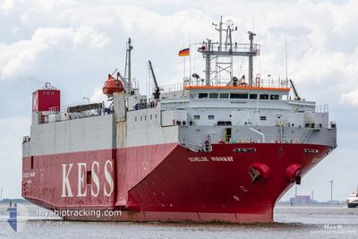
SCHELDE HIGHWAY
Vehicles Carrier
Current Trip
| Time Travelled | 1 day |
|---|---|
| Remaining Time | 19 h, 27 mins |
| Distance Travelled | 332.51 nm |
| Remaining Distance | 263.49 nm |
| AVG Speed | 13.7 Knots |
| MAX Speed | 15.3 Knots |
| AVG Wind | 9.8 knots |
| MAX Wind | 16 knots |
| MIN Temp | 9.5°C / 49.1°F |
| MAX Temp | 12°C / 53.6°F |
| Draught | 4.7 m |
| Position Received | 1 m ago |
Current Position
| Longitude | -2.83534° |
|---|---|
| Latitude | 50.24913° |
| Status | Under way using engine |
| Speed | 12.5 Knots |
| Course | 75.6° |
| Area | English Channel |
| Station | T-AIS |
| Position Received | 1 m ago |
Info
Information
The current position of SCHELDE HIGHWAY is in English Channel with coordinates 50.24913° / -2.83534° as reported on 2024-05-03 20:21 by AIS to our vessel tracker app. The vessel's current speed is 12.5 Knots and is heading at the port of ZEEBRUGGE. The estimated time of arrival as calculated by MyShipTracking vessel tracking app is 2024-05-04 15:49 LT
The vessel SCHELDE HIGHWAY (IMO: 9065405, MMSI: 355444000) is a Vehicles Carrier that was built in 1993 ( 31 years old ). It's sailing under the flag of [PA] Panama.
In this page you can find informations about the vessels current position, last detected port calls, and current voyage information. If the vessels is not in coverage by AIS you will find the latest position.
The current position of SCHELDE HIGHWAY is detected by our AIS receivers and we are not responsible for the reliability of the data. The last position was recorded while the vessel was in Coverage by the Ais receivers of our vessel tracking app.
The current draught of SCHELDE HIGHWAY as reported by AIS is 4.7 meters
Weather
| Temperature | 11.8°C / 53.24°F |
|---|---|
| Wind Speed | 11 knots |
| Direction | 240° WSW |
| Pressure | 1011.8 hPa |
| Humidity | 79.9 % |
| Cloud Coverage | 45 % |
Featured Company
Last Port Calls
| Port | Arrival | Departure | Time In Port |
|---|---|---|---|
| 2024-05-01 15:14 | 2024-05-02 19:23 | 1 d | |
| 2024-04-28 23:16 | 2024-04-29 17:16 | 17 h | |
| 2024-04-27 05:34 | 2024-04-27 11:06 | 5 h | |
| 2024-04-25 16:57 | 2024-04-26 07:26 | 14 h | |
| 2024-04-23 09:38 | 2024-04-23 20:16 | 10 h | |
| 2024-04-20 15:10 | 2024-04-21 13:54 | 22 h | |
| 2024-04-18 16:40 | 2024-04-19 02:27 | 9 h | |
| 2024-04-12 14:50 | 2024-04-13 21:19 | 1 d | |
| 2024-04-08 21:42 | 2024-04-10 14:10 | 1 d | |
| 2024-04-04 16:08 | 2024-04-05 17:50 | 1 d |
Last Trips
| Origin | Departure | Destination | Arrival | Distance | |
|---|---|---|---|---|---|
| 2024-04-29 19:16 | 2024-05-01 16:14 | 578.36 nm | |||
| 2024-04-27 12:06 | 2024-04-29 01:16 | 112.39 nm | |||
| 2024-04-26 09:26 | 2024-04-27 06:34 | 103.47 nm | |||
| 2024-04-23 21:16 | 2024-04-25 18:57 | 589.80 nm | |||
| 2024-04-21 15:54 | 2024-04-23 10:38 | 578.55 nm | |||
| 2024-04-19 03:27 | 2024-04-20 17:10 | 358.41 nm | |||
| 2024-04-13 22:19 | 2024-04-18 17:40 | 1140.70 nm | |||
| 2024-04-10 16:10 | 2024-04-12 15:50 | 579.17 nm | |||
| 2024-04-05 18:50 | 2024-04-08 23:42 | 960.73 nm | |||
| 2024-04-02 15:07 | 2024-04-04 17:08 | 580.25 nm |
Events
| Time | Event | Details | Position / Dest | Info |
|---|---|---|---|---|
| 2024-05-03 19:37 | Status Changed | Under way using engine Default |
50.21142 / -3.07078
ZEEBRUGGE
|
Speed: 13.1 kn Course: 78° |
| 2024-05-03 19:25 | Status Changed | Default Under way using engine |
50.20204 / -3.13976
ZEEBRUGGE
|
Speed: 13.2 kn Course: 78.1° |
| 2024-05-03 13:19 | Change Sea Area | United Kingdom part of the English Channel United Kingdom part of the Celtic Sea |
49.88569 / -5.24941
English Channel
ZEEBRUGGE
|
Speed: 14.2 kn Course: 76° |
| 2024-05-03 13:19 | Status Changed | Under way using engine Default |
49.88569 / -5.24941
ZEEBRUGGE
|
Speed: 14.2 kn Course: 76° |
| 2024-05-03 13:07 | IN Coverage |
49.88569 / -5.24941
English Channel
ZEEBRUGGE
|
Speed: 14.2 kn Course: 76° |
|
| 2024-05-03 12:02 | Status Changed | Default Under way using engine |
49.89529 / -5.70098
ZEEBRUGGE
|
Speed: 13.6 kn Course: 100.5° |
| 2024-05-03 11:57 | Status Changed | Under way using engine Default |
49.89858 / -5.72971
ZEEBRUGGE
|
Speed: 13.6 kn Course: 100° |
| 2024-05-03 11:57 | OUT of Coverage |
49.89858 / -5.72971
Celtic Sea
ZEEBRUGGE
|
Speed: 13.6 kn Course: 100.5° |
|
| 2024-05-03 11:54 | IN Coverage |
49.89858 / -5.72971
Celtic Sea
ZEEBRUGGE
|
Speed: 13.6 kn Course: 100.5° |
|
| 2024-05-03 07:13 | OUT of Coverage |
50.78300 / -6.04021
Celtic Sea
ZEEBRUGGE
|
Speed: 14.1 kn Course: 179.9° |