
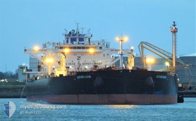
SATURN MOON
Tanker
Current Trip
| Time Travelled | 5 days |
|---|---|
| Remaining Time | 3 days |
| Distance Travelled | 1248.28 nm |
| Remaining Distance | 204.25 nm |
| AVG Speed | 11.2 Knots |
| MAX Speed | 13.3 Knots |
| AVG Wind | 6.1 knots |
| MAX Wind | 15.8 knots |
| MIN Temp | 11.2°C / 52.16°F |
| MAX Temp | 20.3°C / 68.54°F |
| Draught | 12.9 m |
| Position Received | 1 m ago |
Current Position
| Longitude | 28.89814° |
|---|---|
| Latitude | 40.80932° |
| Status | Under way using engine |
| Speed | 0.5 Knots |
| Course | 74° |
| Area | Sea of Marmara |
| Station | T-AIS |
| Position Received | 1 m ago |
Info
Information
The current position of SATURN MOON is in Sea of Marmara with coordinates 40.80932° / 28.89814° as reported on 2024-05-04 18:40 by AIS to our vessel tracker app. The vessel's current speed is 0.5 Knots and is heading at the port of CONSTANTA. The estimated time of arrival as calculated by MyShipTracking vessel tracking app is 2024-05-08 07:33 LT
The vessel SATURN MOON (IMO: 9814430, MMSI: 636019541) is a Tanker It's sailing under the flag of [LR] Liberia.
In this page you can find informations about the vessels current position, last detected port calls, and current voyage information. If the vessels is not in coverage by AIS you will find the latest position.
The current position of SATURN MOON is detected by our AIS receivers and we are not responsible for the reliability of the data. The last position was recorded while the vessel was in Coverage by the Ais receivers of our vessel tracking app.
The current draught of SATURN MOON as reported by AIS is 12.9 meters
Weather
| Temperature | 14°C / 57.2°F |
|---|---|
| Wind Speed | 7 knots |
| Direction | 84° E |
| Pressure | 1008.2 hPa |
| Humidity | 79.4 % |
| Cloud Coverage | 99 % |
Featured Company
Most Visited Ports (Last year)
| Port | Arrivals | |
|---|---|---|
| 3 | ||
| 2 | ||
| 2 | ||
| 1 | ||
| 1 | ||
| 1 |
Events
| Time | Event | Details | Position / Dest | Info |
|---|---|---|---|---|
| 2024-05-04 02:04 | STOP Moving | 8.35 nm, South of YESILKOY |
40.82616 / 28.89369
ROCND
|
Speed: 0.3 kn Course: 28° |
| 2024-05-03 18:12 | Status Changed | Under way using engine Default |
40.55077 / 27.12509
ROCND
|
Speed: 12.3 kn Course: 67° |
| 2024-05-03 17:56 | IN Coverage |
40.55254 / 27.13074
Sea of Marmara
ROCND
|
Speed: 12.3 kn Course: 67.3° |
|
| 2024-05-03 16:26 | Status Changed | Default Under way using engine |
40.40523 / 26.71193
ROCND
|
Speed: 10.3 kn Course: 52.6° |
| 2024-05-03 16:24 | OUT of Coverage |
40.39987 / 26.70279
Sea of Marmara
ROCND
|
Speed: 10.3 kn Course: 52.6° |
|
| 2024-05-03 13:11 | Detected in Sea | Turkish part of the Sea of Marmara |
40.01852 / 26.19416
Sea of Marmara
ROCND
|
Speed: 7.2 kn Course: 74.9° |
| 2024-05-03 11:56 | Status Changed | Under way using engine Default |
39.97906 / 26.02352
ROCND
|
Speed: 4.6 kn Course: 52° |
| 2024-05-03 11:47 | Status Changed | Default Under way using engine |
39.96957 / 26.00838
ROCND
|
Speed: 5.6 kn Course: 49.6° |
| 2024-05-03 11:40 | Status Changed | Under way using engine Default |
39.96359 / 25.99935
ROCND
|
Speed: 5.7 kn Course: 44° |
| 2024-05-03 11:17 | Status Changed | Default Under way using engine |
39.93689 / 25.96367
ROCND
|
Speed: 6.4 kn Course: 44.2° |