

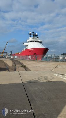
SAR ODIN
Offshore Supply Ship

Current Trip
| Trip Time | 16 days |
|---|---|
| Trip Distance | 400.13 nm |
| AVG Speed | 6.4 Knots |
| MAX Speed | 11.4 Knots |
| Draught | 4.5 m |
| AVG Wind | 12.5 knots |
| MAX Wind | 23.7 knots |
| MIN Temp | 0.6°C / 33.08°F |
| MAX Temp | 6°C / 42.8°F |
| Position Received | 3 m ago |
Current Position
| Longitude | --- |
|---|---|
| Latitude | --- |
| Status | Moored |
| Speed | |
| Course | 27° |
| Area | North Sea |
| Station | T-AIS |
| Position Received | 3 m ago |
Information
The current position of SAR ODIN is in North Sea with coordinates 53.86890° / 8.71034° as reported on 2025-02-18 13:13 by AIS to our vessel tracker app. The vessel's current speed is 0 Knots and is currently inside the port of CUXHAVEN.
The vessel SAR ODIN (IMO: 9249635, MMSI: 259504000) is a Offshore Supply Ship that was built in 2002 ( 23 years old ). It's sailing under the flag of [NO] Norway.
In this page you can find informations about the vessels current position, last detected port calls, and current voyage information. If the vessels is not in coverage by AIS you will find the latest position.
The current position of SAR ODIN is detected by our AIS receivers and we are not responsible for the reliability of the data. The last position was recorded while the vessel was in Coverage by the Ais receivers of our vessel tracking app.
The current draught of SAR ODIN as reported by AIS is 4.5 meters
Weather
| Temperature | 1.9°C / 35.42°F |
|---|---|
| Wind Speed | 7 knots |
| Direction | 128° SE |
| Pressure | 1030.3 hPa |
| Humidity | 37.2 % |
| Cloud Coverage | --- |


Featured Company
Last Trips
| Origin | Departure | Destination | Arrival | Distance | |
|---|---|---|---|---|---|
| 2025-01-30 15:45 | 2025-02-16 16:28 | 400.13 nm | |||
| 2025-01-09 15:35 | 2025-01-23 08:06 | 376.48 nm | |||
| 2024-12-29 17:08 | 2024-12-31 09:19 | 366.68 nm | |||
| 2024-12-25 14:38 | 2024-12-29 04:19 | 372.25 nm | |||
| 2024-12-19 10:33 | 2024-12-21 00:35 | 301.13 nm |
Events
| Time | Event | Details | Position / Dest | Info |
|---|---|---|---|---|
| 2025-02-16 15:51 | Status Changed | Moored Under way using engine |
53.86889 / 8.71033
[DE] CUXHAVEN
|
Speed: Course: 27° |
| 2025-02-16 15:28 | PORT ARRIVAL |
|
53.87107 / 8.71341
[DE] CUXHAVEN
|
Speed: 2.4 kn Course: 49° |
| 2025-02-16 15:25 | STOP Moving | 0.33 nm, North East of CUXHAVEN |
53.87204 / 8.71495
DECUX
|
Speed: 0.3 kn Course: 59° |
| 2025-02-16 14:26 | Draught Changed | 4.5 4.6 |
53.96441 / 8.55520
DECUX
|
Speed: 10.3 kn Course: 101.9° |
| 2025-02-16 14:26 | Destination Changed | DECUX BLYTH |
53.96441 / 8.55520
DECUX
|
Speed: 10.3 kn Course: 101.9° |
| 2025-02-16 14:26 | ETA Changed | 2025/02/16 17:00 2025/02/10 23:00 |
53.96441 / 8.55520
DECUX
|
Speed: 10.3 kn Course: 101.9° |
| 2025-02-16 12:08 | Change Sea Area | German part of the North Sea United Kingdom part of the North Sea |
54.01259 / 8.01031
North Sea
|
Speed: 5.6 kn Course: 122.7° |
| 2025-02-16 12:07 | IN Coverage |
54.01259 / 8.01031
North Sea
|
Speed: 5.6 kn Course: 122.7° |
|
| 2025-02-14 14:24 | OUT of Coverage |
54.94415 / 2.07931
North Sea
|
Speed: 0.1 kn Course: 338.3° |
|
| 2025-02-14 14:24 | IN Coverage |
54.94415 / 2.07931
North Sea
|
Speed: 0.1 kn Course: 338.3° |