
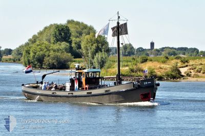
RV 29
Other Type
Current Trip
| Time Travelled | 6 days |
|---|---|
| Remaining Time | --- |
| Distance Travelled | 37.71 nm |
| Remaining Distance | --- |
| AVG Speed | 6.3 Knots |
| MAX Speed | 7.1 Knots |
| AVG Wind | 6.6 knots |
| MAX Wind | 8.4 knots |
| MIN Temp | 6.1°C / 42.98°F |
| MAX Temp | 14.4°C / 57.92°F |
| Draught | 1.9 m |
| Position Received | 6 d ago |
Current Position
| Longitude | 5.25363° |
|---|---|
| Latitude | 51.73408° |
| Status | Moored |
| Speed | 6.6 Knots |
| Course | 63.2° |
| Area | North Sea |
| Station | T-AIS |
| Position Received | 6 d ago |
Info
Information
The current position of RV 29 is in North Sea with coordinates 51.73408° / 5.25363° as reported on 2024-04-29 09:28 by AIS to our vessel tracker app. The vessel's current speed is 6.6 Knots
The vessel RV 29 (MMSI: 244210136) is a Other Type It's sailing under the flag of [NL] Netherlands.
In this page you can find informations about the vessels current position, last detected port calls, and current voyage information. If the vessels is not in coverage by AIS you will find the latest position.
The current position of RV 29 is detected by our AIS receivers and we are not responsible for the reliability of the data. The last position was recorded while the vessel was in Coverage by the Ais receivers of our vessel tracking app.
The current draught of RV 29 as reported by AIS is 1.9 meters
Weather
| Temperature | 13.8°C / 56.84°F |
|---|---|
| Wind Speed | 8 knots |
| Direction | 190° S |
| Pressure | 1019.8 hPa |
| Humidity | 68.9 % |
| Cloud Coverage | 77 % |
Featured Company
Last Port Calls
| Port | Arrival | Departure | Time In Port |
|---|---|---|---|
| 2024-04-29 02:47 | 2024-04-29 03:00 | 12 m | |
| 2024-04-28 09:27 | 2024-04-28 10:14 | 47 m | |
| 2024-04-24 15:40 | 2024-04-25 08:19 | 16 h | |
| 2024-04-24 14:13 | 2024-04-24 14:25 | 11 m | |
| 2024-04-24 09:29 | 2024-04-24 09:46 | 16 m | |
| 2024-03-13 13:20 | 2024-03-13 14:16 | 55 m | |
| 2024-03-13 08:24 | 2024-03-13 10:13 | 1 h |
Most Visited Ports (Last year)
| Port | Arrivals | |
|---|---|---|
| 5 | ||
| 2 | ||
| 2 | ||
| 2 | ||
| 2 | ||
| 1 |
Last Trips
| Origin | Departure | Destination | Arrival | Distance | |
|---|---|---|---|---|---|
| 2024-04-28 12:14 | 2024-04-29 04:47 | 14.20 nm | |||
| 2024-04-25 10:19 | 2024-04-28 11:27 | 6.31 nm | |||
| 2024-04-24 16:25 | 2024-04-24 17:40 | 5.22 nm | |||
| 2024-04-24 11:46 | 2024-04-24 16:13 | 16.67 nm | |||
| 2024-03-13 15:16 | 2024-04-24 11:29 | 56.72 nm | |||
| 2024-03-13 11:13 | 2024-03-13 14:20 | 12.06 nm | |||
| 2024-03-13 11:13 | 2024-03-13 09:24 | 12.06 nm |
Events
| Time | Event | Details | Position / Dest | Info |
|---|---|---|---|---|
| 2024-04-29 09:28 | OUT of Coverage |
51.73408 / 5.25363
North Sea
HEDEL
|
Speed: 6.6 kn Course: 63.2° |
|
| 2024-04-29 03:00 | PORT DEPARTURE |
|
51.90196 / 4.47110
HEDEL
|
Speed: 6.3 kn Course: 75.8° |
| 2024-04-29 02:47 | PORT ARRIVAL |
|
51.90895 / 4.46147
[NL] PARKHAVEN
|
Speed: 2.6 kn Course: 511° |
| 2024-04-29 02:34 | START Moving | 0.56 nm, North of DELFSHAVEN |
51.91548 / 4.44478
HEDEL
|
Speed: 4.2 kn Course: 151.6° |
| 2024-04-28 15:19 | IN Coverage |
51.91763 / 4.44357
North Sea
HEDEL
|
Speed: Course: 511° |
|
| 2024-04-28 13:57 | OUT of Coverage |
51.91810 / 4.44289
North Sea
HEDEL
|
Speed: 2 kn Course: 137° |
|
| 2024-04-28 11:02 | START Moving | 2.79 nm, South West of VOORSCHOTEN |
52.07974 / 4.39626
HEDEL
|
Speed: 3.9 kn Course: 252° |
| 2024-04-28 10:36 | STOP Moving | 2.64 nm, South West of VOORSCHOTEN |
52.08094 / 4.39994
HEDEL
|
Speed: Course: 511° |
| 2024-04-28 10:14 | PORT DEPARTURE |
|
52.09783 / 4.42013
HEDEL
|
Speed: 5.7 kn Course: 235.9° |
| 2024-04-28 10:07 | START Moving |
52.10536 / 4.43462
[NL] VOORSCHOTEN
|
Speed: 5.6 kn Course: 204.1° |