
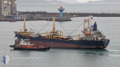
ROMANTIC
Cargo
Current Trip
| Time Travelled | 25 days |
|---|---|
| Remaining Time | 2 days |
| Distance Travelled | 1982.77 nm |
| Remaining Distance | 701.79 nm |
| AVG Speed | 7.3 Knots |
| MAX Speed | 11.2 Knots |
| AVG Wind | 15.3 knots |
| MAX Wind | 28.7 knots |
| MIN Temp | 5.1°C / 41.18°F |
| MAX Temp | 24.4°C / 75.92°F |
| Draught | 4 m |
| Position Received | 25 d ago |
Current Position
| Longitude | --- |
|---|---|
| Latitude | --- |
| Status | Under way using engine |
| Speed | 5.2 Knots |
| Course | 8.1° |
| Area | Eastern China Sea |
| Station | T-AIS |
| Position Received | 25 d ago |
Info
Information
The current position of ROMANTIC is in Eastern China Sea with coordinates 25.23390° / 121.76394° as reported on 2025-02-18 09:55 by AIS to our vessel tracker app. The vessel's current speed is 5.2 Knots and is heading at the port of BUSAN. The estimated time of arrival as calculated by MyShipTracking vessel tracking app is 2025-03-18 17:21 LT
The vessel ROMANTIC (IMO: 9175680, MMSI: 457484000) is a Cargo It's sailing under the flag of [MN] Mongolia.
In this page you can find informations about the vessels current position, last detected port calls, and current voyage information. If the vessels is not in coverage by AIS you will find the latest position.
The current position of ROMANTIC is detected by our AIS receivers and we are not responsible for the reliability of the data. The last position was recorded while the vessel was in Coverage by the Ais receivers of our vessel tracking app.
The current draught of ROMANTIC as reported by AIS is 4 meters
Weather
| Temperature | 16.8°C / 62.24°F |
|---|---|
| Wind Speed | 20 knots |
| Direction | 9° N |
| Pressure | 1018.4 hPa |
| Humidity | 84.6 % |
| Cloud Coverage | 100 % |
Featured Company
Most Visited Ports (Last year)
| Port | Arrivals | |
|---|---|---|
| 7 |
Events
| Time | Event | Details | Position / Dest | Info |
|---|---|---|---|---|
| 2025-03-15 14:18 | START Moving | 12.85 nm, North of KEELUNG |
25.35955 / 121.72463
KR PUSAN
|
Speed: 3.1 kn Course: 61° |
| 2025-03-15 10:18 | STOP Moving | 10.54 nm, North of KEELUNG |
25.32110 / 121.73001
KR PUSAN
|
Speed: 0.1 kn Course: 9° |
| 2025-03-15 00:58 | START Moving |
26.04107 / 122.14301
KR PUSAN
|
Speed: 4.7 kn Course: 182° |
|
| 2025-03-14 00:56 | STOP Moving |
26.05833 / 122.14333
KR PUSAN
|
Speed: Course: -1° |
|
| 2025-03-14 00:45 | START Moving |
26.05942 / 122.14416
KR PUSAN
|
Speed: 3.5 kn Course: 98° |
|
| 2025-03-13 10:11 | STOP Moving |
26.05833 / 122.14333
KR PUSAN
|
Speed: Course: -1° |
|
| 2025-03-13 03:10 | START Moving | 3.18 nm, North of KEELUNG |
25.19567 / 121.73090
KR PUSAN
|
Speed: 4.7 kn Course: 1° |
| 2025-03-11 15:17 | STOP Moving | 2.91 nm, North West of KEELUNG |
25.18990 / 121.72886
KR PUSAN
|
Speed: 0.3 kn Course: 332° |
| 2025-03-11 09:57 | START Moving |
25.95925 / 122.09366
KR PUSAN
|
Speed: 9.6 kn Course: 203° |
|
| 2025-03-08 13:30 | STOP Moving |
26.05893 / 122.14296
KR PUSAN
|
Speed: 0.1 kn Course: 26° |