
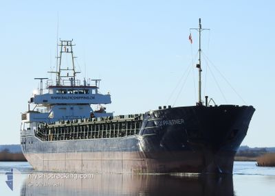
RIX PARTNER
General Cargo
Current Trip
FLIVIK:;
| Time Travelled | 1 day |
|---|---|
| Remaining Time | --- |
| Distance Travelled | 298.88 nm |
| Remaining Distance | --- |
| AVG Speed | 7.1 Knots |
| MAX Speed | 10 Knots |
| AVG Wind | 13.7 knots |
| MAX Wind | 23 knots |
| MIN Temp | -5.2°C / 22.64°F |
| MAX Temp | 2.8°C / 37.04°F |
| Draught | 3.9 m |
| Position Received | 2 m ago |
Current Position
| Longitude | --- |
|---|---|
| Latitude | --- |
| Status | Under way using engine |
| Speed | 7 Knots |
| Course | 251.3° |
| Area | Baltic Sea |
| Station | T-AIS |
| Position Received | 2 m ago |
Info
Information
The current position of RIX PARTNER is in Baltic Sea with coordinates 57.50528° / 16.86676° as reported on 2026-01-08 14:18 by AIS to our vessel tracker app. The vessel's current speed is 7 Knots
The vessel RIX PARTNER (IMO: 9195212, MMSI: 255805980) is a General Cargo that was built in 1998 ( 28 years old ). It's sailing under the flag of [PT] Portugal.
In this page you can find informations about the vessels current position, last detected port calls, and current voyage information. If the vessels is not in coverage by AIS you will find the latest position.
The current position of RIX PARTNER is detected by our AIS receivers and we are not responsible for the reliability of the data. The last position was recorded while the vessel was in Coverage by the Ais receivers of our vessel tracking app.
The current draught of RIX PARTNER as reported by AIS is 3.9 meters
Weather
| Temperature | 0.7°C / 33.26°F |
|---|---|
| Wind Speed | 16 knots |
| Direction | 179° S |
| Pressure | 1014.4 hPa |
| Humidity | 67.1 % |
| Cloud Coverage | 48 % |
Featured Company
Last Port Calls
| Port | Arrival | Departure | Time In Port |
|---|---|---|---|
| 2026-01-05 17:00 | 2026-01-06 20:45 | 1 d | |
| 2025-12-30 08:37 | 2026-01-03 22:04 | 4 d | |
| 2025-12-26 14:28 | 2025-12-26 16:56 | 2 h | |
| 2025-12-18 10:35 | 2025-12-20 21:46 | 2 d | |
| 2025-12-14 09:03 | 2025-12-15 23:12 | 1 d | |
| 2025-12-05 20:55 | 2025-12-09 02:10 | 3 d | |
| 2025-12-03 05:37 | 2025-12-03 21:33 | 15 h | |
| 2025-12-01 06:45 | 2025-12-02 11:25 | 1 d | |
| 2025-11-28 07:53 | 2025-11-29 08:37 | 1 d | |
| 2025-11-25 10:04 | 2025-11-26 14:00 | 1 d |
Most Visited Ports (Last year)
| Port | Arrivals | |
|---|---|---|
| 21 | ||
| 16 | ||
| 6 | ||
| 6 | ||
| 5 | ||
| 4 |
Last Trips
| Origin | Departure | Destination | Arrival | Distance | |
|---|---|---|---|---|---|
| 2026-01-03 22:04 | 2026-01-05 17:00 | 223.99 nm | |||
| 2025-12-26 16:56 | 2025-12-30 08:37 | 626.68 nm | |||
| 2025-12-20 21:46 | 2025-12-26 14:28 | 987.02 nm | |||
| 2025-12-15 23:12 | 2025-12-18 10:35 | 145.65 nm | |||
| 2025-12-09 02:10 | 2025-12-14 09:03 | 1011.94 nm | |||
| 2025-12-03 21:33 | 2025-12-05 20:55 | 1.66 nm | |||
| 2025-12-02 11:25 | 2025-12-03 05:37 | 116.69 nm | |||
| 2025-11-29 08:37 | 2025-12-01 06:45 | 81.67 nm | |||
| 2025-11-26 14:00 | 2025-11-28 07:53 | 271.38 nm | |||
| 2025-11-24 15:12 | 2025-11-25 10:04 | 162.33 nm |
Events
| Time | Event | Details | Position / Dest | Info |
|---|---|---|---|---|
| 2026-01-08 13:47 | Draught Changed | 3.9 3.6 |
57.54998 / 16.97018
FLIVIK:;
|
Speed: 9.1 kn Course: 220.7° |
| 2026-01-08 13:47 | Destination Changed | FLIVIK:; TO ORDER |
57.54998 / 16.97018
FLIVIK:;
|
Speed: 9.1 kn Course: 220.7° |
| 2026-01-08 13:47 | ETA Changed | 2026/01/08 16:00 2026/01/06 22:00 |
57.54998 / 16.97018
FLIVIK:;
|
Speed: 9.1 kn Course: 220.7° |
| 2026-01-08 13:36 | Detected in Sea | Swedish part of the Baltic Sea |
57.57041 / 17.00492
Baltic Sea
|
Speed: 9.2 kn Course: 223° |
| 2026-01-08 13:36 | Status Changed | Under way using engine Default |
57.57166 / 17.00714
TO ORDER
|
Speed: 9 kn Course: 225° |
| 2026-01-08 13:29 | IN Coverage |
57.57041 / 17.00492
Baltic Sea
|
Speed: 9.2 kn Course: 223° |
|
| 2026-01-07 08:19 | Status Changed | Default Under way using engine |
59.53955 / 22.76718
TO ORDER
|
Speed: 6.7 kn Course: 253.1° |
| 2026-01-07 08:13 | OUT of Coverage |
59.54341 / 22.78976
Baltic Sea
|
Speed: 6.7 kn Course: 253.1° |
|
| 2026-01-07 06:46 | Detected in Sea | Finnish part of the Baltic Sea |
59.58701 / 23.10035
Baltic Sea
|
Speed: 6.7 kn Course: 254.4° |
| 2026-01-07 04:03 | Status Changed | Under way using engine Default |
59.64101 / 23.68455
TO ORDER
|
Speed: 6.6 kn Course: 274° |