
RANGER
Bulk Carrier
Current Trip
| Time Travelled | 52 days |
|---|---|
| Remaining Time | --- |
| Distance Travelled | 12240.09 nm |
| Remaining Distance | --- |
| AVG Speed | 10 Knots |
| MAX Speed | 14.5 Knots |
| AVG Wind | 12.8 knots |
| MAX Wind | 28 knots |
| MIN Temp | 16.5°C / 61.7°F |
| MAX Temp | 30.7°C / 87.26°F |
| Draught | 13.9 m |
| Position Received | 9 d ago |
Current Position
| Longitude | 104.20739° |
|---|---|
| Latitude | 1.26955° |
| Status | Under way using engine |
| Speed | 12.8 Knots |
| Course | 81.8° |
| Area | Singapore Strait |
| Station | T-AIS |
| Position Received | 9 d ago |
Info
Information
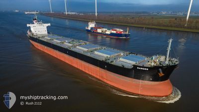
The current position of RANGER is in Singapore Strait with coordinates 1.26955° / 104.20739° as reported on 2024-06-19 16:34 by AIS to our vessel tracker app. The vessel's current speed is 12.8 Knots and is heading at the port of ZHOUSHAN. The estimated time of arrival as calculated by MyShipTracking vessel tracking app is 2024-06-26 06:00 LT
The vessel RANGER (IMO: 9493999, MMSI: 636092950) is a Bulk Carrier that was built in 2012 ( 12 years old ). It's sailing under the flag of [LR] Liberia.
In this page you can find informations about the vessels current position, last detected port calls, and current voyage information. If the vessels is not in coverage by AIS you will find the latest position.
The current position of RANGER is detected by our AIS receivers and we are not responsible for the reliability of the data. The last position was recorded while the vessel was in Coverage by the Ais receivers of our vessel tracking app.
The current draught of RANGER as reported by AIS is 13.9 meters
Weather
| Temperature | 25.8°C / 78.44°F |
|---|---|
| Wind Speed | 26 knots |
| Direction | 199° SSW |
| Pressure | 1004.4 hPa |
| Humidity | 87 % |
| Cloud Coverage | 100 % |
Featured Company
Last Port Calls
| Port | Arrival | Departure | Time In Port |
|---|---|---|---|
| 2024-05-04 20:52 | 2024-05-07 23:40 | 3 d |
Most Visited Ports (Last year)
| Port | Arrivals | |
|---|---|---|
| 1 | ||
| 1 | ||
| 1 | ||
| 1 | ||
| 1 |
Last Trips
| Origin | Departure | Destination | Arrival | Distance | |
|---|---|---|---|---|---|
| 2024-03-20 23:32 | 2024-05-04 17:52 | 9478.60 nm |
Events
| Time | Event | Details | Position / Dest | Info |
|---|---|---|---|---|
| 2024-06-27 07:53 | STOP Moving |
29.80430 / 122.76722
CN ZOS
|
Speed: Course: 310° |
|
| 2024-06-19 16:41 | Status Changed | Default Under way using engine |
1.27362 / 104.23452
CN ZOS
|
Speed: 12.8 kn Course: 81.8° |
| 2024-06-19 16:34 | OUT of Coverage |
1.26955 / 104.20739
Singapore Strait
CN ZOS
|
Speed: 12.8 kn Course: 81.8° |
|
| 2024-06-19 16:16 | Change Sea Area | Malaysian part of the Singapore Strait Indonesian part of the Singapore Strait |
1.26149 / 104.14400
Singapore Strait
CN ZOS
|
Speed: 12.7 kn Course: 82.9° |
| 2024-06-19 15:23 | Change Sea Area | Indonesian part of the Singapore Strait Singaporean part of the Singapore Strait |
1.23981 / 103.96856
Singapore Strait
CN ZOS
|
Speed: 9.4 kn Course: 135.9° |
| 2024-06-19 14:56 | START Moving | 4.88 nm, South West of TANAH MERAH |
1.27446 / 103.94590
CN ZOS
|
Speed: 3.1 kn Course: 162° |
| 2024-06-19 14:53 | Status Changed | Under way using engine At anchor |
1.27590 / 103.94465
CN ZOS
|
Speed: 1.2 kn Course: 184° |
| 2024-06-19 12:07 | Draught Changed | 13.9 13.5 |
1.27490 / 103.94174
CN ZOS
|
Speed: Course: 50° |
| 2024-06-19 12:07 | ETA Changed | 2024/06/26 06:00 2024/06/26 12:00 |
1.27490 / 103.94174
CN ZOS
|
Speed: Course: 50° |
| 2024-06-19 12:01 | ETA Changed | 2024/06/26 12:00 2024/06/27 12:00 |
1.27483 / 103.94171
CN ZOS
|
Speed: Course: 48° |