
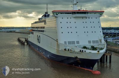
PRIDE OF HULL
Ro-Ro/Passenger Ship
Current Trip
| Time Travelled | 9 h, 47 mins |
|---|---|
| Remaining Time | 1 h, 9 mins |
| Distance Travelled | 172.46 nm |
| Remaining Distance | --- |
| AVG Speed | 17.9 Knots |
| MAX Speed | 20.5 Knots |
| AVG Wind | 11.3 knots |
| MAX Wind | 17.6 knots |
| MIN Temp | 3.1°C / 37.58°F |
| MAX Temp | 7.4°C / 45.32°F |
| Draught | 5.8 m |
| Position Received | 1 m ago |
Current Position
| Longitude | 3.60789° |
|---|---|
| Latitude | 52.08623° |
| Status | Under way using engine |
| Speed | 15.9 Knots |
| Course | 113.9° |
| Area | North Sea |
| Station | T-AIS |
| Position Received | 1 m ago |
Info
Information
The current position of PRIDE OF HULL is in North Sea with coordinates 52.08623° / 3.60789° as reported on 2024-04-26 05:00 by AIS to our vessel tracker app. The vessel's current speed is 15.9 Knots and is heading at the port of ROTTERDAM. The estimated time of arrival as calculated by MyShipTracking vessel tracking app is 2024-04-26 06:10 LT
The vessel PRIDE OF HULL (IMO: 9208629, MMSI: 311062900) is a Ro-Ro/Passenger Ship that was built in 2001 ( 23 years old ). It's sailing under the flag of [BS] Bahamas.
In this page you can find informations about the vessels current position, last detected port calls, and current voyage information. If the vessels is not in coverage by AIS you will find the latest position.
The current position of PRIDE OF HULL is detected by our AIS receivers and we are not responsible for the reliability of the data. The last position was recorded while the vessel was in Coverage by the Ais receivers of our vessel tracking app.
The current draught of PRIDE OF HULL as reported by AIS is 5.8 meters
Weather
| Temperature | 7.2°C / 44.96°F |
|---|---|
| Wind Speed | 10 knots |
| Direction | 292° WNW |
| Pressure | 1001.4 hPa |
| Humidity | 67.8 % |
| Cloud Coverage | 53 % |
Featured Company
Last Port Calls
| Port | Arrival | Departure | Time In Port |
|---|---|---|---|
| 2024-04-25 05:54 | 2024-04-25 19:14 | 13 h | |
| 2024-04-24 06:23 | 2024-04-24 19:12 | 12 h | |
| 2024-04-23 05:59 | 2024-04-23 19:24 | 13 h | |
| 2024-04-22 06:16 | 2024-04-22 19:21 | 13 h | |
| 2024-04-21 06:43 | 2024-04-21 19:16 | 12 h | |
| 2024-04-20 06:39 | 2024-04-20 18:42 | 12 h | |
| 2024-04-19 06:03 | 2024-04-19 19:34 | 13 h | |
| 2024-04-18 06:31 | 2024-04-18 18:51 | 12 h | |
| 2024-04-17 07:01 | 2024-04-17 19:51 | 12 h | |
| 2024-04-16 07:20 | 2024-04-16 19:40 | 12 h |
Most Visited Ports (Last year)
| Port | Arrivals | |
|---|---|---|
| 184 | ||
| 178 | ||
| 1 |
Last Trips
| Origin | Departure | Destination | Arrival | Distance | |
|---|---|---|---|---|---|
| 2024-04-24 21:12 | 2024-04-25 06:54 | 195.37 nm | |||
| 2024-04-23 20:24 | 2024-04-24 08:23 | 196.15 nm | |||
| 2024-04-22 21:21 | 2024-04-23 06:59 | 195.89 nm | |||
| 2024-04-21 20:16 | 2024-04-22 08:16 | 196.58 nm | |||
| 2024-04-20 20:42 | 2024-04-21 07:43 | 194.55 nm | |||
| 2024-04-19 20:34 | 2024-04-20 08:39 | 196.44 nm | |||
| 2024-04-18 20:51 | 2024-04-19 07:03 | 195.67 nm | |||
| 2024-04-17 20:51 | 2024-04-18 08:31 | 197.79 nm | |||
| 2024-04-16 21:40 | 2024-04-17 08:01 | 195.96 nm | |||
| 2024-04-15 20:26 | 2024-04-16 09:20 | 202.77 nm |
Events
| Time | Event | Details | Position / Dest | Info |
|---|---|---|---|---|
| 2024-04-26 04:19 | Change Sea Area | Dutch part of the North Sea United Kingdom part of the North Sea |
52.17261 / 3.34411
North Sea
EURO-HULL-EURO
|
Speed: 17.1 kn Course: 133° |
| 2024-04-26 04:19 | Status Changed | Under way using engine Default |
52.17261 / 3.34411
EURO-HULL-EURO
|
Speed: 17.2 kn Course: 133° |
| 2024-04-26 04:14 | IN Coverage |
52.17261 / 3.34411
North Sea
EURO-HULL-EURO
|
Speed: 17.1 kn Course: 133° |
|
| 2024-04-26 02:24 | Status Changed | Default Under way using engine |
52.53693 / 2.64291
EURO-HULL-EURO
|
Speed: 18 kn Course: 130.6° |
| 2024-04-26 02:16 | Status Changed | Under way using engine Default |
52.56279 / 2.59179
EURO-HULL-EURO
|
Speed: 17.9 kn Course: 130° |
| 2024-04-26 02:16 | OUT of Coverage |
52.56279 / 2.59179
North Sea
EURO-HULL-EURO
|
Speed: 18 kn Course: 130.6° |
|
| 2024-04-26 02:04 | IN Coverage |
52.56279 / 2.59179
North Sea
EURO-HULL-EURO
|
Speed: 18 kn Course: 130.6° |
|
| 2024-04-26 01:12 | Status Changed | Default Under way using engine |
52.77134 / 2.19308
EURO-HULL-EURO
|
Speed: 17.9 kn Course: 132.6° |
| 2024-04-26 01:04 | OUT of Coverage |
52.79995 / 2.14252
North Sea
EURO-HULL-EURO
|
Speed: 17.9 kn Course: 132.6° |
|
| 2024-04-25 22:34 | Status Changed | Under way using engine Default |
53.26616 / 1.13111
EURO-HULL-EURO
|
Speed: 19 kn Course: 133° |