
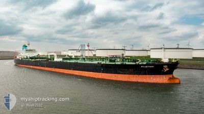
PHAETHON
Crude Oil Tanker
Current Trip
| Time Travelled | 28 days |
|---|---|
| Remaining Time | --- |
| Distance Travelled | 5103.34 nm |
| Remaining Distance | --- |
| AVG Speed | 9.1 Knots |
| MAX Speed | 14.5 Knots |
| AVG Wind | 13.1 knots |
| MAX Wind | 38.9 knots |
| MIN Temp | 2.7°C / 36.86°F |
| MAX Temp | 29.7°C / 85.46°F |
| Draught | 9.5 m |
| Position Received | 9 d ago |
Current Position
| Longitude | -15.24458° |
|---|---|
| Latitude | 27.46188° |
| Status | Under way using engine |
| Speed | 10.1 Knots |
| Course | 195° |
| Area | North Atlantic Ocean |
| Station | T-AIS |
| Position Received | 9 d ago |
Info
Information
The current position of PHAETHON is in North Atlantic Ocean with coordinates 27.46188° / -15.24458° as reported on 2024-04-19 16:50 by AIS to our vessel tracker app. The vessel's current speed is 10.1 Knots and is heading at the port of CAP LOPEZ. The estimated time of arrival as calculated by MyShipTracking vessel tracking app is 2024-05-02 22:00 LT
The vessel PHAETHON (IMO: 9412098, MMSI: 240836000) is a Crude Oil Tanker that was built in 2009 ( 15 years old ). It's sailing under the flag of [GR] Greece.
In this page you can find informations about the vessels current position, last detected port calls, and current voyage information. If the vessels is not in coverage by AIS you will find the latest position.
The current position of PHAETHON is detected by our AIS receivers and we are not responsible for the reliability of the data. The last position was recorded while the vessel was in Coverage by the Ais receivers of our vessel tracking app.
The current draught of PHAETHON as reported by AIS is 9.5 meters
Weather
| Temperature | 28.9°C / 84.02°F |
|---|---|
| Wind Speed | 7 knots |
| Direction | 162° SSE |
| Pressure | 1008.1 hPa |
| Humidity | 77.8 % |
| Cloud Coverage | 84 % |
Featured Company
Most Visited Ports (Last year)
| Port | Arrivals | |
|---|---|---|
| 3 | ||
| 3 | ||
| 1 | ||
| 1 | ||
| 1 | ||
| 1 |
Events
| Time | Event | Details | Position / Dest | Info |
|---|---|---|---|---|
| 2024-04-19 17:06 | Status Changed | Default Under way using engine |
27.41857 / -15.25553
GACLZ
|
Speed: 10.1 kn Course: 195° |
| 2024-04-19 16:50 | OUT of Coverage |
27.46188 / -15.24458
North Atlantic Ocean
GACLZ
|
Speed: 10.1 kn Course: 195° |
|
| 2024-04-19 16:36 | Status Changed | Under way using engine Default |
27.50057 / -15.23373
GACLZ
|
Speed: 9.8 kn Course: 182° |
| 2024-04-19 16:30 | Status Changed | Default Under way using engine |
27.51817 / -15.23290
GACLZ
|
Speed: 10 kn Course: 183° |
| 2024-04-19 12:20 | START Moving | 2.69 nm, North East of LAS PALMAS |
28.16393 / -15.38633
GACLZ
|
Speed: 3.1 kn Course: 76° |
| 2024-04-19 12:07 | Status Changed | Under way using engine At anchor |
28.16218 / -15.38973
GACLZ
|
Speed: 0.2 kn Course: 21° |
| 2024-04-19 11:47 | Destination Changed | GACLZ LAS PALMAS |
28.16093 / -15.39153
GACLZ
|
Speed: 0.1 kn Course: 22° |
| 2024-04-19 11:47 | ETA Changed | 2024/05/02 22:00 2024/04/16 11:30 |
28.16093 / -15.39153
GACLZ
|
Speed: 0.1 kn Course: 22° |
| 2024-04-19 07:51 | Status Changed | At anchor Default |
28.16067 / -15.39142
LAS PALMAS
|
Speed: 0.1 kn Course: 4° |
| 2024-04-19 07:45 | Status Changed | Default At anchor |
28.16065 / -15.39137
LAS PALMAS
|
Speed: Course: 359° |