
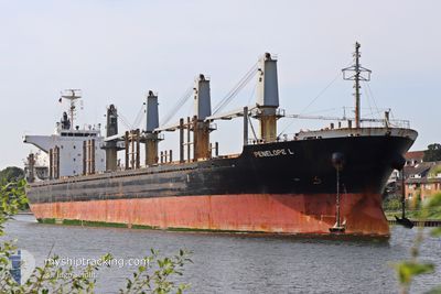
PENELOPE L
Cargo
Current Trip
| Trip Time | --- |
|---|---|
| Trip Distance | --- |
| AVG Speed | --- |
| MAX Speed | --- |
| Draught | --- |
| AVG Wind | --- |
| MAX Wind | --- |
| MIN Temp | --- |
| MAX Temp | --- |
| Position Received | 5 d ago |
Current Position
| Longitude | --- |
|---|---|
| Latitude | --- |
| Status | Under way using engine |
| Speed | 11.6 Knots |
| Course | 171.4° |
| Area | Mediterranean Sea - Eastern Basin |
| Station | T-AIS |
| Position Received | 5 d ago |
Info
Information
The current position of PENELOPE L is in Mediterranean Sea - Eastern Basin with coordinates 35.58472° / 14.63585° as reported on 2025-12-08 13:42 by AIS to our vessel tracker app. The vessel's current speed is 11.6 Knots and is currently inside the port of MISURATA.
The vessel PENELOPE L (IMO: 9714343, MMSI: 636016826) is a Cargo It's sailing under the flag of [LR] Liberia.
In this page you can find informations about the vessels current position, last detected port calls, and current voyage information. If the vessels is not in coverage by AIS you will find the latest position.
The current position of PENELOPE L is detected by our AIS receivers and we are not responsible for the reliability of the data. The last position was recorded while the vessel was in Coverage by the Ais receivers of our vessel tracking app.
The current draught of PENELOPE L as reported by AIS is 9.7 meters
Weather
| Temperature | 19°C / 66.2°F |
|---|---|
| Wind Speed | 8 knots |
| Direction | 64° ENE |
| Pressure | 1021.8 hPa |
| Humidity | 61.8 % |
| Cloud Coverage | 7 % |
Featured Company
Last Port Calls
| Port | Arrival | Departure | Time In Port |
|---|---|---|---|
| 2025-11-13 08:28 | 2025-11-18 10:14 | 5 d | |
| 2025-10-27 04:32 | 2025-10-28 21:36 | 1 d | |
| 2025-10-13 14:40 |
Most Visited Ports (Last year)
| Port | Arrivals | |
|---|---|---|
| 3 | ||
| 2 | ||
| 1 | ||
| 1 | ||
| 1 | ||
| 1 |
Last Trips
| Origin | Departure | Destination | Arrival | Distance | |
|---|---|---|---|---|---|
| 2025-10-28 21:36 | 2025-11-13 08:28 | 46.66 nm | |||
| 2025-10-13 14:40 | 2025-10-27 04:32 | 2951.41 nm |
Events
| Time | Event | Details | Position / Dest | Info |
|---|---|---|---|---|
| 2025-12-08 13:47 | Status Changed | Default Under way using engine |
35.56835 / 14.63926
MT MLA>>LY MRA
|
Speed: 11.6 kn Course: 171.4° |
| 2025-12-08 13:42 | Status Changed | Under way using engine Default |
35.58472 / 14.63585
MT MLA>>LY MRA
|
Speed: 11.5 kn Course: 171° |
| 2025-12-08 13:42 | OUT of Coverage |
35.58472 / 14.63585
Mediterranean Sea - Eastern Basin
MT MLA>>LY MRA
|
Speed: 11.6 kn Course: 171.4° |
|
| 2025-12-08 13:33 | Status Changed | Default Under way using engine |
35.61417 / 14.62994
MT MLA>>LY MRA
|
Speed: 11.3 kn Course: 170.6° |
| 2025-12-08 12:22 | Status Changed | Under way using engine At anchor |
35.82207 / 14.58900
MT MLA>>LY MRA
|
Speed: 4.5 kn Course: 150° |
| 2025-12-08 12:16 | Status Changed | At anchor Default |
35.82041 / 14.58256
MT MLA>>LY MRA
|
Speed: 1.7 kn Course: 321° |
| 2025-12-08 12:16 | START Moving | 1.75 nm, East of MARSAXLOKK |
35.82041 / 14.58256
MT MLA>>LY MRA
|
Speed: 3.1 kn Course: 19° |
| 2025-12-08 12:13 | Status Changed | Default At anchor |
35.81862 / 14.58384
MT MLA>>LY MRA
|
Speed: 0.6 kn Course: 285° |
| 2025-12-08 12:07 | Status Changed | At anchor Default |
35.81815 / 14.58515
MT MLA>>LY MRA
|
Speed: 0.6 kn Course: 287° |
| 2025-12-08 12:04 | Status Changed | Default At anchor |
35.81791 / 14.58576
MT MLA>>LY MRA
|
Speed: Course: 282° |