

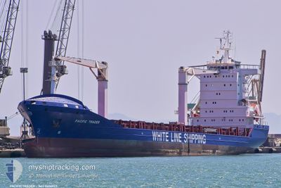
PACIFIC TRADER
General Cargo

Current Trip
| Trip Time | 4 days |
|---|---|
| Trip Distance | 1216.59 nm |
| AVG Speed | 12.4 Knots |
| MAX Speed | 15.2 Knots |
| Draught | 8 m |
| AVG Wind | 13.8 knots |
| MAX Wind | 24.5 knots |
| MIN Temp | 21.9°C / 71.42°F |
| MAX Temp | 29.1°C / 84.38°F |
| Position Received | 6 d ago |
Current Position
| Longitude | --- |
|---|---|
| Latitude | --- |
| Status | Under way using engine |
| Speed | 9.6 Knots |
| Course | 116.2° |
| Area | Gulf of Mexico |
| Station | T-AIS |
| Position Received | 6 d ago |
Information
The current position of PACIFIC TRADER is in Gulf of Mexico with coordinates 22.41503° / -97.49320° as reported on 2025-03-22 17:43 by AIS to our vessel tracker app. The vessel's current speed is 9.6 Knots and is currently inside the port of KINGSTON (JM).
The vessel PACIFIC TRADER (IMO: 9406922, MMSI: 210749000) is a General Cargo that was built in 2008 ( 17 years old ). It's sailing under the flag of [CY] Cyprus.
In this page you can find informations about the vessels current position, last detected port calls, and current voyage information. If the vessels is not in coverage by AIS you will find the latest position.
The current position of PACIFIC TRADER is detected by our AIS receivers and we are not responsible for the reliability of the data. The last position was recorded while the vessel was in Coverage by the Ais receivers of our vessel tracking app.
The current draught of PACIFIC TRADER as reported by AIS is 8 meters
Weather
| Temperature | 20.3°C / 68.54°F |
|---|---|
| Wind Speed | 3 knots |
| Direction | 27° NNE |
| Pressure | 1015 hPa |
| Humidity | 90.9 % |
| Cloud Coverage | 97 % |


Featured Company
Last Port Calls
| Port | Arrival | Departure | Time In Port |
|---|---|---|---|
| 2025-03-28 19:20 | |||
| 2025-03-23 23:27 | 2025-03-24 15:17 | 15 h | |
| 2025-03-21 21:24 | 2025-03-22 09:57 | 12 h | |
| 2025-03-16 04:35 | 2025-03-17 00:44 | 20 h | |
| 2025-03-13 22:11 | 2025-03-14 06:51 | 8 h | |
| 2025-03-11 07:28 | 2025-03-11 23:49 | 16 h | |
| 2025-03-08 08:17 | 2025-03-09 04:51 | 20 h | |
| 2025-03-05 04:59 | 2025-03-06 23:04 | 1 d | |
| 2025-02-27 10:54 | 2025-02-28 00:03 | 13 h | |
| 2025-02-24 22:16 | 2025-02-25 23:22 | 1 d |
Last Trips
| Origin | Departure | Destination | Arrival | Distance | |
|---|---|---|---|---|---|
| 2025-03-24 15:17 | 2025-03-28 19:20 | 1216.59 nm | |||
| 2025-03-22 09:57 | 2025-03-23 23:27 | 254.50 nm | |||
| 2025-03-17 00:44 | 2025-03-21 21:24 | 1333.76 nm | |||
| 2025-03-14 06:51 | 2025-03-16 04:35 | 11.00 nm | |||
| 2025-03-11 23:49 | 2025-03-13 22:11 | 641.40 nm | |||
| 2025-03-09 04:51 | 2025-03-11 07:28 | 262.96 nm | |||
| 2025-03-06 23:04 | 2025-03-08 08:17 | 418.36 nm | |||
| 2025-02-28 00:03 | 2025-03-05 04:59 | 1225.60 nm | |||
| 2025-02-25 23:22 | 2025-02-27 10:54 | 238.62 nm | |||
| 2025-02-22 21:23 | 2025-02-24 22:16 | 495.69 nm |
Events
| Time | Event | Details | Position / Dest | Info |
|---|---|---|---|---|
| 2025-03-29 00:52 | STOP Moving |
17.98497 / -76.83118
[JM] KINGSTON (JM)
|
Speed: 0.1 kn Course: 131° |
|
| 2025-03-29 00:20 | PORT ARRIVAL |
|
17.96733 / -76.83353
[JM] KINGSTON (JM)
|
Speed: 11.1 kn Course: 64° |
| 2025-03-24 21:17 | PORT DEPARTURE |
|
19.20244 / -96.11541
MXVER
|
Speed: 7 kn Course: 111° |
| 2025-03-24 21:12 | START Moving |
19.20523 / -96.13055
[MX] VERACRUZ
|
Speed: 7 kn Course: 111° |
|
| 2025-03-24 06:09 | STOP Moving |
19.21077 / -96.13903
[MX] VERACRUZ
|
Speed: Course: 238° |
|
| 2025-03-24 05:27 | PORT ARRIVAL |
|
19.20718 / -96.13240
[MX] VERACRUZ
|
Speed: 6.7 kn Course: 268° |
| 2025-03-23 21:23 | START Moving | 13.49 nm, North of VERACRUZ |
19.41323 / -96.03949
MXVER
|
Speed: 4.8 kn Course: 44° |
| 2025-03-23 14:50 | STOP Moving | 16.27 nm, North East of VERACRUZ |
19.43693 / -95.97927
MXVER
|
Speed: 0.3 kn Course: 344° |
| 2025-03-22 17:44 | Status Changed | Default Under way using engine |
22.41357 / -97.49049
MXVER
|
Speed: 9.6 kn Course: 116.2° |
| 2025-03-22 17:43 | OUT of Coverage |
22.41503 / -97.49320
Gulf of Mexico
MXVER
|
Speed: 9.6 kn Course: 116.2° |