
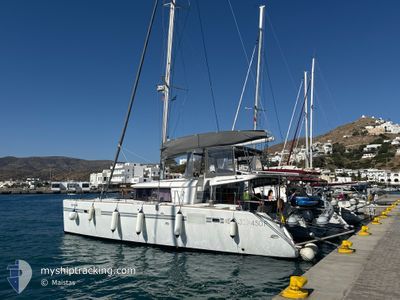
NO RUSH !
Sailing
Current Trip
| Trip Time | 4 days |
|---|---|
| Trip Distance | 114.36 nm |
| AVG Speed | 6.7 Knots |
| MAX Speed | 8.6 Knots |
| Draught | --- |
| AVG Wind | 7.2 knots |
| MAX Wind | 16.4 knots |
| MIN Temp | 16.3°C / 61.34°F |
| MAX Temp | 26.4°C / 79.52°F |
| Position Received | 1 d ago |
Current Position
| Longitude | --- |
|---|---|
| Latitude | --- |
| Status | Default |
| Speed | 0.1 Knots |
| Course | 207° |
| Area | Ionian Sea |
| Station | T-AIS |
| Position Received | 1 d ago |
Info
Information
The current position of NO RUSH ! is in Ionian Sea with coordinates 38.37689° / 22.38817° as reported on 2024-10-17 11:41 by AIS to our vessel tracker app. The vessel's current speed is 0.1 Knots and is currently inside the port of GALAKSIDI.
The vessel NO RUSH ! (MMSI: 503120330) is a Sailing It's sailing under the flag of [AU] Australia.
In this page you can find informations about the vessels current position, last detected port calls, and current voyage information. If the vessels is not in coverage by AIS you will find the latest position.
The current position of NO RUSH ! is detected by our AIS receivers and we are not responsible for the reliability of the data. The last position was recorded while the vessel was in Coverage by the Ais receivers of our vessel tracking app.
Weather
| Temperature | 17.3°C / 63.14°F |
|---|---|
| Wind Speed | 6 knots |
| Direction | 51° NE |
| Pressure | 1025 hPa |
| Humidity | 55.7 % |
| Cloud Coverage | 81 % |
Featured Company
Last Port Calls
| Port | Arrival | Departure | Time In Port |
|---|---|---|---|
| 2024-10-17 11:03 | |||
| 2024-10-16 09:27 | 2024-10-16 11:13 | 1 h | |
| 2024-10-13 13:43 | |||
| 2024-10-12 13:42 | 2024-10-12 13:44 | 1 m | |
| 2024-10-10 07:52 | 2024-10-11 07:11 | 23 h | |
| 2024-10-09 08:00 | 2024-10-09 13:33 | 5 h | |
| 2024-09-12 12:06 | 2024-10-05 03:40 | 22 d | |
| 2024-09-10 13:08 | 2024-09-12 09:08 | 1 d |
Last Trips
| Origin | Departure | Destination | Arrival | Distance | |
|---|---|---|---|---|---|
| 2024-10-12 16:44 | 2024-10-17 14:03 | 114.36 nm | |||
| 2024-10-12 16:44 | 2024-10-16 12:27 | 72.51 nm | |||
| 2024-10-12 16:44 | 2024-10-13 16:43 | 29.57 nm | |||
| 2024-10-09 16:33 | 2024-10-10 10:52 | 10.28 nm | |||
| 2024-10-05 06:40 | 2024-10-09 11:00 | 76.84 nm | |||
| 2024-09-12 12:08 | 2024-09-12 15:06 | 10.88 nm | |||
| 2024-07-29 12:36 | 2024-09-10 16:08 | 175.06 nm |
Events
| Time | Event | Details | Position / Dest | Info |
|---|---|---|---|---|
| 2024-10-17 11:41 | OUT of Coverage |
38.37689 / 22.38817
Ionian Sea
[GR] GALAKSIDI
|
Speed: 0.1 kn Course: 359.9° |
|
| 2024-10-17 11:07 | STOP Moving |
38.37687 / 22.38818
[GR] GALAKSIDI
|
Speed: Course: 204° |
|
| 2024-10-17 11:03 | PORT ARRIVAL |
|
38.37830 / 22.38919
[GR] GALAKSIDI
|
Speed: 4 kn Course: 210° |
| 2024-10-17 08:28 | IN Coverage |
38.17032 / 22.65206
Ionian Sea
|
Speed: 8.1 kn Course: 313.5° |
|
| 2024-10-17 06:11 | OUT of Coverage |
38.00566 / 22.91300
Ionian Sea
|
Speed: 6.8 kn Course: 210.5° |
|
| 2024-10-17 06:11 | START Moving | 3.38 nm, North West of LOUTRAKI |
38.00566 / 22.91300
|
Speed: 6.8 kn Course: 210.5° |
| 2024-10-17 05:42 | IN Coverage |
38.00721 / 22.92429
Ionian Sea
|
Speed: 0.2 kn Course: 356° |
|
| 2024-10-16 11:35 | OUT of Coverage |
37.99213 / 22.93057
Ionian Sea
|
Speed: 6.7 kn Course: 330° |
|
| 2024-10-16 11:13 | PORT DEPARTURE |
|
37.95750 / 22.95506
|
Speed: 7.1 kn Course: 329° |
| 2024-10-16 11:11 | Change Sea Area | Greek part of the Ionian Sea Greek part of the Aegean Sea |
37.95413 / 22.95749
Ionian Sea
|
Speed: 7.1 kn Course: 330.4° |