
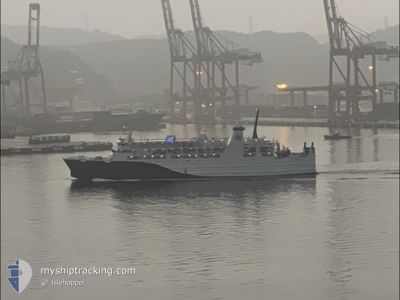
NEW TAIMA
Passenger
Current Trip
| Trip Time | 17 h, 59 mins |
|---|---|
| Trip Distance | 252.33 nm |
| AVG Speed | 15.5 Knots |
| MAX Speed | 20 Knots |
| Draught | 4.3 m |
| AVG Wind | 13.8 knots |
| MAX Wind | 17 knots |
| MIN Temp | 13.6°C / 56.48°F |
| MAX Temp | 20.6°C / 69.08°F |
| Position Received | 28 d ago |
Current Position
| Longitude | --- |
|---|---|
| Latitude | --- |
| Status | Under way using engine |
| Speed | 13.3 Knots |
| Course | 304.2° |
| Area | Eastern China Sea |
| Station | T-AIS |
| Position Received | 28 d ago |
Info
Information
The current position of NEW TAIMA is in Eastern China Sea with coordinates 25.49283° / 121.36388° as reported on 2025-12-05 16:35 by AIS to our vessel tracker app. The vessel's current speed is 13.3 Knots and is currently inside the port of KEELUNG.
The vessel NEW TAIMA (IMO: 9939709, MMSI: 416009193) is a Passenger It's sailing under the flag of [TW] Taiwan.
In this page you can find informations about the vessels current position, last detected port calls, and current voyage information. If the vessels is not in coverage by AIS you will find the latest position.
The current position of NEW TAIMA is detected by our AIS receivers and we are not responsible for the reliability of the data. The last position was recorded while the vessel was in Coverage by the Ais receivers of our vessel tracking app.
The current draught of NEW TAIMA as reported by AIS is 4.3 meters
Weather
| Temperature | 15.4°C / 59.72°F |
|---|---|
| Wind Speed | 18 knots |
| Direction | 64° ENE |
| Pressure | 1025.5 hPa |
| Humidity | 67.8 % |
| Cloud Coverage | 98 % |
Featured Company
Last Port Calls
| Port | Arrival | Departure | Time In Port |
|---|---|---|---|
| 2025-12-29 16:24 | |||
| 2025-12-28 17:36 | 2025-12-28 22:25 | 4 h | |
| 2025-12-23 17:14 | 2025-12-27 22:28 | 4 d | |
| 2025-12-20 17:10 | 2025-12-22 22:26 | 2 d | |
| 2025-12-19 16:06 | 2025-12-19 22:30 | 6 h | |
| 2025-12-17 15:38 | 2025-12-18 22:26 | 1 d | |
| 2025-12-16 17:22 | 2025-12-16 22:22 | 5 h | |
| 2025-12-11 17:09 | 2025-12-15 22:21 | 4 d | |
| 2025-12-07 15:21 | 2025-12-10 22:21 | 3 d | |
| 2025-12-06 17:12 | 2025-12-06 22:45 | 5 h |
Last Trips
| Origin | Departure | Destination | Arrival | Distance | |
|---|---|---|---|---|---|
| 2025-12-28 22:25 | 2025-12-29 16:24 | 252.33 nm | |||
| 2025-12-27 22:28 | 2025-12-28 17:36 | 251.59 nm | |||
| 2025-12-22 22:26 | 2025-12-23 17:14 | 254.67 nm | |||
| 2025-12-19 22:30 | 2025-12-20 17:10 | 252.34 nm | |||
| 2025-12-18 22:26 | 2025-12-19 16:06 | 253.16 nm | |||
| 2025-12-16 22:22 | 2025-12-17 15:38 | 253.62 nm | |||
| 2025-12-15 22:21 | 2025-12-16 17:22 | 251.59 nm | |||
| 2025-12-10 22:21 | 2025-12-11 17:09 | 251.89 nm | |||
| 2025-12-06 22:45 | 2025-12-07 15:21 | 252.44 nm | |||
| 2025-12-05 22:12 | 2025-12-06 17:12 | 253.55 nm |
Events
| Time | Event | Details | Position / Dest | Info |
|---|---|---|---|---|
| 2025-12-29 08:24 | PORT ARRIVAL |
|
25.14999 / 121.75560
[TW] KEELUNG
|
Speed: 16.5 kn Course: 136° |
| 2025-12-29 02:08 | START Moving | 9.9 nm, South of LIAN JIANG |
26.16232 / 119.93891
MATSU FUAO_TW
|
Speed: 5.1 kn Course: 341° |
| 2025-12-29 00:56 | STOP Moving | 9.99 nm, South of LIAN JIANG |
26.16172 / 119.94234
MATSU FUAO_TW
|
Speed: 0.1 kn Course: 100° |
| 2025-12-28 23:12 | START Moving |
26.35521 / 120.46165
MATSU FUAO_TW
|
Speed: 19 kn Course: 244° |
|
| 2025-12-28 22:09 | STOP Moving |
26.36431 / 120.48387
MATSU FUAO_TW
|
Speed: Course: 154° |
|
| 2025-12-28 14:25 | PORT DEPARTURE |
|
25.16828 / 121.75292
MATSU FUAO_TW
|
Speed: 10.9 kn Course: 350° |
| 2025-12-28 09:57 | STOP Moving |
25.13436 / 121.74138
[TW] KEELUNG
|
Speed: Course: 215° |
|
| 2025-12-28 09:36 | PORT ARRIVAL |
|
25.16161 / 121.75291
[TW] KEELUNG
|
Speed: 20.6 kn Course: 154° |
| 2025-12-28 04:30 | START Moving |
26.35791 / 120.47526
MATSU FUAO_TW
|
Speed: 16.5 kn Course: 180° |
|
| 2025-12-28 03:31 | STOP Moving |
26.36333 / 120.48333
MATSU FUAO_TW
|
Speed: Course: -1° |