
NEW LEGACY
Cargo
Current Trip
| Time Travelled | 2 days |
|---|---|
| Remaining Time | --- |
| Distance Travelled | 601.57 nm |
| Remaining Distance | --- |
| AVG Speed | 10.8 Knots |
| MAX Speed | 12.1 Knots |
| AVG Wind | 7.6 knots |
| MAX Wind | 21.8 knots |
| MIN Temp | 10°C / 50°F |
| MAX Temp | 12.4°C / 54.32°F |
| Draught | 9.5 m |
| Position Received | 2 d ago |
Current Position
| Longitude | -132.20441° |
|---|---|
| Latitude | 54.33578° |
| Status | Under way using engine |
| Speed | 11.6 Knots |
| Course | 274.2° |
| Area | The Coastal Waters of Southeast Alaska and British Columbia |
| Station | T-AIS |
| Position Received | 2 d ago |
Info
Information
The current position of NEW LEGACY is in The Coastal Waters of Southeast Alaska and British Columbia with coordinates 54.33578° / -132.20441° as reported on 2024-06-23 05:57 by AIS to our vessel tracker app. The vessel's current speed is 11.6 Knots and is heading at the port of SENDAI. The estimated time of arrival as calculated by MyShipTracking vessel tracking app is 2024-07-06 05:00 LT
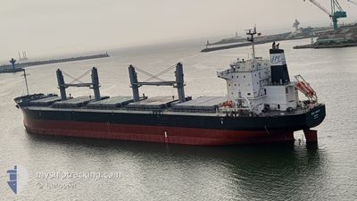
The vessel NEW LEGACY (IMO: 9804942, MMSI: 636018067) is a Cargo It's sailing under the flag of [LR] Liberia.
In this page you can find informations about the vessels current position, last detected port calls, and current voyage information. If the vessels is not in coverage by AIS you will find the latest position.
The current position of NEW LEGACY is detected by our AIS receivers and we are not responsible for the reliability of the data. The last position was recorded while the vessel was in Coverage by the Ais receivers of our vessel tracking app.
The current draught of NEW LEGACY as reported by AIS is 9.5 meters
Weather
| Temperature | 10.2°C / 50.36°F |
|---|---|
| Wind Speed | 6 knots |
| Direction | 106° ESE |
| Pressure | 1018.5 hPa |
| Humidity | 86.2 % |
| Cloud Coverage | 98 % |
Featured Company
Last Port Calls
| Port | Arrival | Departure | Time In Port |
|---|---|---|---|
| 2024-06-16 23:45 | 2024-06-22 23:39 | 5 d | |
| 2024-06-15 01:15 | 2024-06-15 01:43 | 28 m | |
| 2024-05-21 03:32 | 2024-05-29 10:14 | 8 d | |
| 2024-05-16 22:04 | 2024-05-18 08:16 | 1 d | |
| 2024-04-04 21:53 |
Last Trips
| Origin | Departure | Destination | Arrival | Distance | |
|---|---|---|---|---|---|
| 2024-06-14 18:43 | 2024-06-16 16:45 | 4.52 nm | |||
| 2024-05-29 19:14 | 2024-06-14 18:15 | 4193.59 nm | |||
| 2024-05-18 17:16 | 2024-05-21 12:32 | 13.75 nm | |||
| 2024-04-05 06:53 | 2024-05-17 07:04 | 1862.01 nm |
Events
| Time | Event | Details | Position / Dest | Info |
|---|---|---|---|---|
| 2024-06-23 06:03 | Status Changed | Default Under way using engine |
54.33669 / -132.23621
JP SGM
|
Speed: 11.6 kn Course: 274.2° |
| 2024-06-23 05:57 | OUT of Coverage |
54.33578 / -132.20441
The Coastal Waters of Southeast Alaska and British Columbia
JP SGM
|
Speed: 11.6 kn Course: 274.2° |
|
| 2024-06-23 05:15 | Status Changed | Under way using engine Default |
54.33276 / -131.97603
JP SGM
|
Speed: 11 kn Course: 271° |
| 2024-06-23 05:11 | Status Changed | Default Under way using engine |
54.33282 / -131.95705
JP SGM
|
Speed: 11.2 kn Course: 272.8° |
| 2024-06-22 23:39 | PORT DEPARTURE |
|
54.27576 / -130.36496
JP SGM
|
Speed: 7.7 kn Course: 170° |
| 2024-06-22 23:20 | START Moving |
54.30691 / -130.34845
[CA] PRINCE RUPERT
|
Speed: 3.7 kn Course: 250° |
|
| 2024-06-22 23:00 | Status Changed | Under way using engine Moored |
54.30717 / -130.34391
[CA] PRINCE RUPERT
|
Speed: Course: 230° |
| 2024-06-22 21:29 | Status Changed | Moored Default |
54.30717 / -130.34393
[CA] PRINCE RUPERT
|
Speed: 0.1 kn Course: 230° |
| 2024-06-22 21:26 | Status Changed | Default Moored |
54.30719 / -130.34392
[CA] PRINCE RUPERT
|
Speed: 0.1 kn Course: 230° |
| 2024-06-22 21:10 | Draught Changed | 9.5 9.6 |
54.30718 / -130.34394
[CA] PRINCE RUPERT
|
Speed: Course: 230° |