
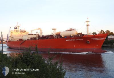
NAVIGATOR GUSTO
Lpg Tanker
Current Trip
| Time Travelled | 12 days |
|---|---|
| Remaining Time | --- |
| Distance Travelled | 4006.66 nm |
| Remaining Distance | --- |
| AVG Speed | 13.7 Knots |
| MAX Speed | 16.2 Knots |
| AVG Wind | 11.9 knots |
| MAX Wind | 21 knots |
| MIN Temp | 14.5°C / 58.1°F |
| MAX Temp | 26.6°C / 79.88°F |
| Draught | 9.1 m |
| Position Received | 1 h, 14 m ago |
Current Position
| Longitude | -24.84370° |
|---|---|
| Latitude | 41.10018° |
| Status | Under way using engine |
| Speed | 12.3 Knots |
| Course | 52.5° |
| Area | North Atlantic Ocean |
| Station | T-AIS |
| Position Received | 1 h, 14 m ago |
Info
Information
The current position of NAVIGATOR GUSTO is in North Atlantic Ocean with coordinates 41.10018° / -24.84370° as reported on 2024-05-13 21:34 by AIS to our vessel tracker app. The vessel's current speed is 12.3 Knots and is heading at the port of PORSGRUNN. The estimated time of arrival as calculated by MyShipTracking vessel tracking app is 2024-05-19 20:00 LT
The vessel NAVIGATOR GUSTO (IMO: 9531507, MMSI: 636015944) is a Lpg Tanker that was built in 2011 ( 13 years old ). It's sailing under the flag of [LR] Liberia.
In this page you can find informations about the vessels current position, last detected port calls, and current voyage information. If the vessels is not in coverage by AIS you will find the latest position.
The current position of NAVIGATOR GUSTO is detected by our AIS receivers and we are not responsible for the reliability of the data. The last position was recorded while the vessel was in Coverage by the Ais receivers of our vessel tracking app.
The current draught of NAVIGATOR GUSTO as reported by AIS is 9.1 meters
Weather
| Temperature | 14.5°C / 58.1°F |
|---|---|
| Wind Speed | 16 knots |
| Direction | 1° N |
| Pressure | 1030.3 hPa |
| Humidity | 66.5 % |
| Cloud Coverage | 31 % |
Featured Company
Last Port Calls
| Port | Arrival | Departure | Time In Port |
|---|---|---|---|
| 2024-04-30 18:45 | 2024-05-01 15:34 | 20 h | |
| 2024-04-24 23:50 | 2024-04-26 15:50 | 1 d | |
| 2024-04-03 11:20 | 2024-04-04 09:16 | 21 h | |
| 2024-03-30 12:29 | 2024-03-31 03:15 | 14 h | |
| 2024-03-12 13:14 | 2024-03-13 11:38 | 22 h |
Last Trips
| Origin | Departure | Destination | Arrival | Distance | |
|---|---|---|---|---|---|
| 2024-04-26 10:50 | 2024-04-30 13:45 | 97.73 nm | |||
| 2024-04-04 11:16 | 2024-04-24 18:50 | 6241.34 nm | |||
| 2024-03-31 05:15 | 2024-04-03 13:20 | 857.37 nm | |||
| 2024-03-13 07:38 | 2024-03-30 13:29 | 4681.60 nm | |||
| 2024-02-27 03:17 | 2024-03-12 09:14 | 4520.57 nm |
Events
| Time | Event | Details | Position / Dest | Info |
|---|---|---|---|---|
| 2024-05-13 21:46 | Status Changed | Default Under way using engine |
41.12173 / -24.80449
NOHRY
|
Speed: 12.3 kn Course: 52.5° |
| 2024-05-13 21:34 | OUT of Coverage |
41.10018 / -24.84370
North Atlantic Ocean
NOHRY
|
Speed: 12.3 kn Course: 52.5° |
|
| 2024-05-13 21:08 | Status Changed | Under way using engine Default |
41.04980 / -24.94703
NOHRY
|
Speed: 12.3 kn Course: 57° |
| 2024-05-13 20:51 | IN Coverage |
41.04980 / -24.94703
North Atlantic Ocean
NOHRY
|
Speed: 12.5 kn Course: 59.7° |
|
| 2024-05-13 18:27 | Status Changed | Default Under way using engine |
40.75805 / -25.56103
NOHRY
|
Speed: 12.7 kn Course: 59.8° |
| 2024-05-13 18:23 | OUT of Coverage |
40.74973 / -25.57785
North Atlantic Ocean
NOHRY
|
Speed: 12.7 kn Course: 59.8° |
|
| 2024-05-13 18:11 | Status Changed | Under way using engine Default |
40.72713 / -25.62444
NOHRY
|
Speed: 12.8 kn Course: 59° |
| 2024-05-13 17:54 | Status Changed | Default Under way using engine |
40.69285 / -25.68971
NOHRY
|
Speed: 12.9 kn Course: 51.5° |
| 2024-05-13 17:49 | Status Changed | Under way using engine Default |
40.68200 / -25.70824
NOHRY
|
Speed: 12.9 kn Course: 52° |
| 2024-05-13 17:45 | Status Changed | Default Under way using engine |
40.67461 / -25.72087
NOHRY
|
Speed: 13 kn Course: 53° |