
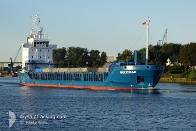
MULTIMAR
General Cargo
Current Trip
| Trip Time | 1 day |
|---|---|
| Trip Distance | 494.88 nm |
| AVG Speed | 11.1 Knots |
| MAX Speed | 11.7 Knots |
| Draught | 4.1 m |
| AVG Wind | 10.9 knots |
| MAX Wind | 21.6 knots |
| MIN Temp | 10.8°C / 51.44°F |
| MAX Temp | 18.3°C / 64.94°F |
| Position Received | 1 d ago |
Current Position
| Longitude | 20.88650° |
|---|---|
| Latitude | 63.55567° |
| Status | Under way using engine |
| Speed | 10.8 Knots |
| Course | 72.9° |
| Area | Gulf of Bothnia |
| Station | T-AIS |
| Position Received | 1 d ago |
Info
Information
The current position of MULTIMAR is in Gulf of Bothnia with coordinates 63.55567° / 20.88650° as reported on 2024-06-26 07:54 by AIS to our vessel tracker app. The vessel's current speed is 10.8 Knots and is currently inside the port of VIRPIPERA.
The vessel MULTIMAR (IMO: 9143788, MMSI: 212575000) is a General Cargo that was built in 1997 ( 27 years old ). It's sailing under the flag of [CY] Cyprus.
In this page you can find informations about the vessels current position, last detected port calls, and current voyage information. If the vessels is not in coverage by AIS you will find the latest position.
The current position of MULTIMAR is detected by our AIS receivers and we are not responsible for the reliability of the data. The last position was recorded while the vessel was in Coverage by the Ais receivers of our vessel tracking app.
The current draught of MULTIMAR as reported by AIS is 4.1 meters
Weather
| Temperature | 14.3°C / 57.74°F |
|---|---|
| Wind Speed | 8 knots |
| Direction | 109° ESE |
| Pressure | 1015.4 hPa |
| Humidity | 68.9 % |
| Cloud Coverage | 4 % |
Featured Company
Last Port Calls
| Port | Arrival | Departure | Time In Port |
|---|---|---|---|
| 2024-06-26 22:21 | |||
| 2024-06-21 14:15 | 2024-06-25 00:14 | 3 d | |
| 2024-06-18 21:02 | 2024-06-20 16:21 | 1 d | |
| 2024-06-17 23:41 | 2024-06-18 01:01 | 1 h | |
| 2024-06-14 00:53 | 2024-06-17 18:44 | 3 d | |
| 2024-06-13 19:56 | 2024-06-13 20:11 | 14 m | |
| 2024-06-07 07:19 | 2024-06-08 08:05 | 1 d | |
| 2024-06-04 16:43 | 2024-06-07 02:07 | 2 d | |
| 2024-06-02 11:34 | 2024-06-04 00:19 | 1 d | |
| 2024-05-31 01:00 | 2024-05-31 02:23 | 1 h |
Last Trips
| Origin | Departure | Destination | Arrival | Distance | |
|---|---|---|---|---|---|
| 2024-06-25 00:14 | 2024-06-26 22:21 | 494.88 nm | |||
| 2024-06-20 16:21 | 2024-06-21 14:15 | 207.02 nm | |||
| 2024-06-18 01:01 | 2024-06-18 21:02 | 212.67 nm | |||
| 2024-06-17 18:44 | 2024-06-17 23:41 | 49.01 nm | |||
| 2024-06-13 20:11 | 2024-06-14 00:53 | 49.01 nm | |||
| 2024-06-08 08:05 | 2024-06-13 19:56 | 884.37 nm | |||
| 2024-06-07 02:07 | 2024-06-07 07:19 | 15.80 nm | |||
| 2024-06-04 00:19 | 2024-06-04 16:43 | 154.48 nm | |||
| 2024-05-31 02:23 | 2024-06-02 11:34 | 440.32 nm | |||
| 2024-05-28 12:15 | 2024-05-31 01:00 | 650.94 nm |
Events
| Time | Event | Details | Position / Dest | Info |
|---|---|---|---|---|
| 2024-06-26 19:38 | STOP Moving |
64.65546 / 24.41011
[FI] VIRPIPERA
|
Speed: Course: 180° |
|
| 2024-06-26 19:21 | PORT ARRIVAL |
|
64.65950 / 24.40550
[FI] VIRPIPERA
|
Speed: 4.8 kn Course: 94° |
| 2024-06-26 07:58 | Status Changed | Default Under way using engine |
63.55981 / 20.91317
FIRAA
|
Speed: 10.8 kn Course: 72.9° |
| 2024-06-26 07:54 | OUT of Coverage |
63.55567 / 20.88650
Gulf of Bothnia
FIRAA
|
Speed: 10.8 kn Course: 72.9° |
|
| 2024-06-26 07:39 | Status Changed | Under way using engine Default |
63.54383 / 20.79633
FIRAA
|
Speed: 10.4 kn Course: 55° |
| 2024-06-26 07:30 | Status Changed | Default Under way using engine |
63.53233 / 20.74017
FIRAA
|
Speed: 10.4 kn Course: 44.7° |
| 2024-06-26 07:12 | Change Sea Area | Swedish part of the Gulf of Bothnia Finnish part of the Gulf of Bothnia |
63.48809 / 20.67644
Gulf of Bothnia
FIRAA
|
Speed: 10.7 kn Course: 28.8° |
| 2024-06-26 07:11 | Status Changed | Under way using engine Default |
63.48718 / 20.67531
FIRAA
|
Speed: 10.7 kn Course: 31° |
| 2024-06-26 06:50 | Status Changed | Default Under way using engine |
63.43185 / 20.60203
FIRAA
|
Speed: 10.7 kn Course: 32° |
| 2024-06-26 06:22 | ETA Changed | 2024/06/26 21:30 2024/06/26 21:00 |
63.36333 / 20.50700
FIRAA
|
Speed: 10.6 kn Course: 32.1° |