

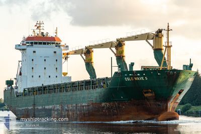
MSC WAVE F
General Cargo

Current Trip
| Trip Time | 22 h, 24 mins |
|---|---|
| Trip Distance | 271.62 nm |
| AVG Speed | 12.5 Knots |
| MAX Speed | 15.2 Knots |
| Draught | 6.7 m |
| AVG Wind | 20.4 knots |
| MAX Wind | 29.3 knots |
| MIN Temp | 12.7°C / 54.86°F |
| MAX Temp | 14°C / 57.2°F |
| Position Received | 1 m ago |
Current Position
| Longitude | --- |
|---|---|
| Latitude | --- |
| Status | Under way using engine |
| Speed | 7.6 Knots |
| Course | 347° |
| Area | Tyrrhenian Sea |
| Station | T-AIS |
| Position Received | 1 m ago |
Information
The current position of MSC WAVE F is in Tyrrhenian Sea with coordinates 44.08821° / 9.84610° as reported on 2025-03-13 16:41 by AIS to our vessel tracker app. The vessel's current speed is 7.6 Knots and is currently inside the port of LA SPEZIA.
The vessel MSC WAVE F (IMO: 9232462, MMSI: 636021255) is a General Cargo that was built in 2001 ( 24 years old ). It's sailing under the flag of [LR] Liberia.
In this page you can find informations about the vessels current position, last detected port calls, and current voyage information. If the vessels is not in coverage by AIS you will find the latest position.
The current position of MSC WAVE F is detected by our AIS receivers and we are not responsible for the reliability of the data. The last position was recorded while the vessel was in Coverage by the Ais receivers of our vessel tracking app.
The current draught of MSC WAVE F as reported by AIS is 6.7 meters
Weather
| Temperature | 13.6°C / 56.48°F |
|---|---|
| Wind Speed | 23 knots |
| Direction | 218° SW |
| Pressure | 998.9 hPa |
| Humidity | 79 % |
| Cloud Coverage | 100 % |


Featured Company
Last Port Calls
| Port | Arrival | Departure | Time In Port |
|---|---|---|---|
| 2025-03-13 17:35 | |||
| 2025-03-11 17:51 | 2025-03-12 19:11 | 1 d | |
| 2025-03-04 00:19 | 2025-03-10 08:41 | 6 d | |
| 2025-02-22 21:40 | 2025-02-23 21:51 | 1 d | |
| 2025-02-20 01:36 | 2025-02-20 23:53 | 22 h | |
| 2025-02-12 13:54 | 2025-02-17 12:47 | 4 d | |
| 2025-02-05 22:25 | 2025-02-06 09:53 | 11 h | |
| 2025-02-04 19:07 | 2025-02-05 09:11 | 14 h | |
| 2025-02-02 11:04 | 2025-02-04 01:05 | 1 d | |
| 2025-01-25 17:32 | 2025-01-31 20:14 | 6 d |
Last Trips
| Origin | Departure | Destination | Arrival | Distance | |
|---|---|---|---|---|---|
| 2025-03-12 19:11 | 2025-03-13 17:35 | 271.62 nm | |||
| 2025-03-10 08:41 | 2025-03-11 17:51 | 420.90 nm | |||
| 2025-02-23 21:51 | 2025-03-04 00:19 | 488.34 nm | |||
| 2025-02-20 23:53 | 2025-02-22 21:40 | 281.84 nm | |||
| 2025-02-17 12:47 | 2025-02-20 01:36 | 558.59 nm | |||
| 2025-02-06 09:53 | 2025-02-12 13:54 | 331.16 nm | |||
| 2025-02-05 09:11 | 2025-02-05 22:25 | 198.83 nm | |||
| 2025-02-04 01:05 | 2025-02-04 19:07 | 269.56 nm | |||
| 2025-01-31 20:14 | 2025-02-02 11:04 | 554.04 nm | |||
| 2025-01-22 19:55 | 2025-01-25 17:32 | 601.98 nm |
Events
| Time | Event | Details | Position / Dest | Info |
|---|---|---|---|---|
| 2025-03-13 16:35 | PORT ARRIVAL |
|
44.07657 / 9.85037
[IT] LA SPEZIA
|
Speed: 8.2 kn Course: 343.9° |
| 2025-03-13 11:46 | Change Sea Area | Italian part of the Tyrrhenian Sea Italian part of the Ligurian Sea |
43.90634 / 9.81073
Tyrrhenian Sea
ITSPE
|
Speed: 14.2 kn Course: 46° |
| 2025-03-13 11:09 | Status Changed | Under way using engine Default |
43.80362 / 9.66478
ITSPE
|
Speed: 14.6 kn Course: 65° |
| 2025-03-13 10:50 | Status Changed | Default Under way using engine |
43.77260 / 9.56938
ITSPE
|
Speed: 14.6 kn Course: 69° |
| 2025-03-13 10:49 | Status Changed | Under way using engine Default |
43.77081 / 9.56287
ITSPE
|
Speed: 14.4 kn Course: 69° |
| 2025-03-13 10:29 | IN Coverage |
43.77081 / 9.56287
Ligurian Sea
ITSPE
|
Speed: 14.6 kn Course: 69° |
|
| 2025-03-13 08:25 | Status Changed | Default Under way using engine |
43.53393 / 8.81072
ITSPE
|
Speed: 14.9 kn Course: 64° |
| 2025-03-13 08:19 | OUT of Coverage |
43.52423 / 8.78102
Ligurian Sea
ITSPE
|
Speed: 14.9 kn Course: 64° |
|
| 2025-03-13 07:17 | Change Sea Area | Italian part of the Ligurian Sea Italian part of the Mediterranean Sea - Western Basin |
43.41918 / 8.45788
Ligurian Sea
ITSPE
|
Speed: 14.7 kn Course: 67° |
| 2025-03-13 06:28 | Status Changed | Under way using engine Default |
43.33992 / 8.20822
ITSPE
|
Speed: 14.6 kn Course: 69° |