

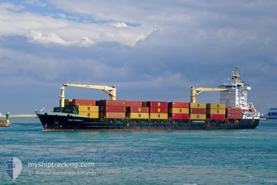
MSC SIGMA F
General Cargo

Current Trip
| Time Travelled | 2 days |
|---|---|
| Remaining Time | --- |
| Distance Travelled | 220.77 nm |
| Remaining Distance | --- |
| AVG Speed | 11.3 Knots |
| MAX Speed | 18.7 Knots |
| AVG Wind | 7.2 knots |
| MAX Wind | 14.8 knots |
| MIN Temp | 25.7°C / 78.26°F |
| MAX Temp | 33.1°C / 91.58°F |
| Draught | 8.1 m |
| Position Received | 2024-05-31 21:23 |
Current Position
| Longitude | --- |
|---|---|
| Latitude | --- |
| Status | Under way using engine |
| Speed | 12.2 Knots |
| Course | 199.6° |
| Area | North Atlantic Ocean |
| Station | T-AIS |
| Position Received | 2024-05-31 21:23 |
Information
The current position of MSC SIGMA F is in North Atlantic Ocean with coordinates 27.64933° / -15.29300° as reported on 2024-05-31 21:23 by AIS to our vessel tracker app. The vessel's current speed is 12.2 Knots and is heading at the port of NOUAKCHOTT.
The vessel MSC SIGMA F (IMO: 9330240, MMSI: 636021079) is a General Cargo that was built in 2007 ( 18 years old ). It's sailing under the flag of [LR] Liberia.
In this page you can find informations about the vessels current position, last detected port calls, and current voyage information. If the vessels is not in coverage by AIS you will find the latest position.
The current position of MSC SIGMA F is detected by our AIS receivers and we are not responsible for the reliability of the data. The last position was recorded while the vessel was in Coverage by the Ais receivers of our vessel tracking app.
The current draught of MSC SIGMA F as reported by AIS is 8.1 meters
Weather
| Temperature | 27.3°C / 81.14°F |
|---|---|
| Wind Speed | 5 knots |
| Direction | 195° SSW |
| Pressure | 1009.7 hPa |
| Humidity | 81.1 % |
| Cloud Coverage | 87 % |


Featured Company
Last Port Calls
| Port | Arrival | Departure | Time In Port |
|---|---|---|---|
| 2025-03-23 16:54 | 2025-03-25 11:00 | 1 d | |
| 2025-03-21 09:44 | 2025-03-22 08:21 | 22 h | |
| 2025-03-14 16:50 | 2025-03-16 10:38 | 1 d | |
| 2025-03-12 08:40 | 2025-03-13 11:52 | 1 d | |
| 2025-03-09 17:28 | 2025-03-11 12:23 | 1 d | |
| 2025-03-07 13:28 | 2025-03-08 18:56 | 1 d | |
| 2025-03-03 16:26 | 2025-03-05 13:45 | 1 d | |
| 2025-02-26 21:16 | 2025-02-28 15:36 | 1 d | |
| 2025-02-20 16:11 | 2025-02-22 12:40 | 1 d | |
| 2025-02-17 07:48 | 2025-02-19 04:28 | 1 d |
Most Visited Ports (Last year)
| Port | Arrivals | |
|---|---|---|
| 22 | ||
| 20 | ||
| 7 | ||
| 6 | ||
| 5 | ||
| 4 |
Last Trips
| Origin | Departure | Destination | Arrival | Distance | |
|---|---|---|---|---|---|
| 2025-03-22 08:21 | 2025-03-23 16:54 | 224.64 nm | |||
| 2025-03-16 10:38 | 2025-03-21 09:44 | 227.80 nm | |||
| 2025-03-13 11:52 | 2025-03-14 16:50 | 223.33 nm | |||
| 2025-03-11 12:23 | 2025-03-12 08:40 | 226.01 nm | |||
| 2025-03-08 18:56 | 2025-03-09 17:28 | 224.35 nm | |||
| 2025-03-05 13:45 | 2025-03-07 13:28 | 223.47 nm | |||
| 2025-02-28 15:36 | 2025-03-03 16:26 | 598.91 nm | |||
| 2025-02-22 12:40 | 2025-02-26 21:16 | 225.29 nm | |||
| 2025-02-19 04:28 | 2025-02-20 16:11 | 229.88 nm | |||
| 2025-02-14 10:18 | 2025-02-17 07:48 | 223.28 nm |
Events
| Time | Event | Details | Position / Dest | Info |
|---|---|---|---|---|
| 2025-03-26 07:24 | STOP Moving | 2.3 nm, West of POINTE NOIRE |
-4.77847 / 11.79685
MRNKC
|
Speed: 0.1 kn Course: 217° |
| 2025-03-25 10:04 | START Moving | 1.38 nm, West of MATADI |
-5.82623 / 13.43293
MRNKC
|
Speed: 15.1 kn Course: 255° |
| 2025-03-25 10:00 | PORT DEPARTURE |
|
-5.82623 / 13.43293
MRNKC
|
Speed: Course: 82° |
| 2025-03-23 15:54 | STOP Moving |
-5.82246 / 13.45048
[CD] MATADI
|
Speed: 0.3 kn Course: 81° |
|
| 2025-03-23 15:54 | PORT ARRIVAL |
|
-5.82246 / 13.45048
[CD] MATADI
|
Speed: 1.1 kn Course: 75° |
| 2025-03-23 07:01 | START Moving | 2.66 nm, South of BANANA |
-6.04399 / 12.39349
MRNKC
|
Speed: 8 kn Course: 116° |
| 2025-03-23 06:33 | STOP Moving | 2.68 nm, South of BANANA |
-6.04189 / 12.38442
MRNKC
|
Speed: 0.2 kn Course: 120° |
| 2025-03-22 07:21 | PORT DEPARTURE |
|
-4.76801 / 11.82897
MRNKC
|
Speed: 4.7 kn Course: 326° |
| 2025-03-22 07:09 | START Moving |
-4.78100 / 11.83139
[CG] POINTE NOIRE
|
Speed: 4.5 kn Course: 52° |
|
| 2025-03-21 09:05 | STOP Moving |
-4.77882 / 11.82905
[CG] POINTE NOIRE
|
Speed: 0.3 kn Course: 275° |