
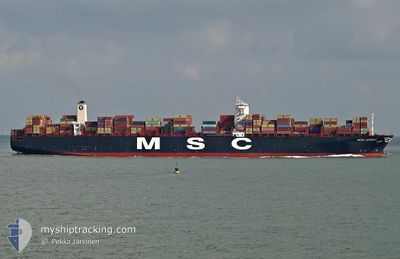
MSC EMMA
Container Ship
Current Trip
| Time Travelled | 3 days |
|---|---|
| Remaining Time | --- |
| Distance Travelled | 1039.62 nm |
| Remaining Distance | 872.07 nm |
| AVG Speed | 11.9 Knots |
| MAX Speed | 15 Knots |
| AVG Wind | 4.9 knots |
| MAX Wind | 11 knots |
| MIN Temp | 21.8°C / 71.24°F |
| MAX Temp | 30.7°C / 87.26°F |
| Draught | 16 m |
| Position Received | 5 d ago |
Current Position
| Longitude | -102.47694° |
|---|---|
| Latitude | 17.77227° |
| Status | Under way using engine |
| Speed | 15.1 Knots |
| Course | 275° |
| Area | North Pacific Ocean |
| Station | T-AIS |
| Position Received | 5 d ago |
Info
Information
The current position of MSC EMMA is in North Pacific Ocean with coordinates 17.77227° / -102.47694° as reported on 2024-05-08 10:14 by AIS to our vessel tracker app. The vessel's current speed is 15.1 Knots and is heading at the port of LAZARO CARDENAS. The estimated time of arrival as calculated by MyShipTracking vessel tracking app is 2024-05-06 17:00 LT
The vessel MSC EMMA (IMO: 9463047, MMSI: 636018571) is a Container Ship that was built in 2011 ( 13 years old ). It's sailing under the flag of [LR] Liberia.
In this page you can find informations about the vessels current position, last detected port calls, and current voyage information. If the vessels is not in coverage by AIS you will find the latest position.
The current position of MSC EMMA is detected by our AIS receivers and we are not responsible for the reliability of the data. The last position was recorded while the vessel was in Coverage by the Ais receivers of our vessel tracking app.
The current draught of MSC EMMA as reported by AIS is 16 meters
Weather
| Temperature | 29.4°C / 84.92°F |
|---|---|
| Wind Speed | 11 knots |
| Direction | 231° SW |
| Pressure | 1008.7 hPa |
| Humidity | 75.9 % |
| Cloud Coverage | 100 % |
Featured Company
Last Port Calls
| Port | Arrival | Departure | Time In Port |
|---|---|---|---|
| 2024-05-08 22:47 | 2024-05-10 12:44 | 1 d | |
| 2024-05-07 16:50 | 2024-05-08 08:42 | 15 h | |
| 2024-04-17 11:00 | 2024-04-18 22:00 | 1 d | |
| 2024-04-14 02:42 | 2024-04-15 02:46 | 1 d | |
| 2024-04-09 06:29 | 2024-04-09 09:33 | 3 h | |
| 2024-04-08 16:05 | 2024-04-09 06:20 | 14 h | |
| 2024-04-08 09:01 | 2024-04-08 15:59 | 6 h | |
| 2024-03-28 20:52 | 2024-03-29 23:40 | 1 d | |
| 2024-03-10 21:44 | 2024-03-12 02:02 | 1 d |
Most Visited Ports (Last year)
| Port | Arrivals | |
|---|---|---|
| 5 | ||
| 5 | ||
| 4 | ||
| 4 | ||
| 3 | ||
| 2 |
Last Trips
| Origin | Departure | Destination | Arrival | Distance | |
|---|---|---|---|---|---|
| 2024-05-08 03:42 | 2024-05-08 17:47 | 170.23 nm | |||
| 2024-04-19 07:00 | 2024-05-07 11:50 | 6653.54 nm | |||
| 2024-04-15 10:46 | 2024-04-17 20:00 | 492.36 nm | |||
| 2024-04-09 17:33 | 2024-04-14 10:42 | 528.63 nm | |||
| 2024-04-09 14:20 | 2024-04-09 14:29 | 0.11 nm | |||
| 2024-04-08 23:59 | 2024-04-09 00:05 | 0.12 nm | |||
| 2024-03-30 07:40 | 2024-04-08 17:01 | 1178.66 nm | |||
| 2024-03-11 20:02 | 2024-03-29 04:52 | 8085.30 nm | |||
| 2024-02-19 05:45 | 2024-03-10 15:44 | 4051.52 nm |
Events
| Time | Event | Details | Position / Dest | Info |
|---|---|---|---|---|
| 2024-05-10 12:44 | PORT DEPARTURE |
|
19.04667 / -104.38333
KRPUS>MXLZC
|
Speed: 10.8 kn Course: 230° |
| 2024-05-10 11:59 | START Moving |
19.06667 / -104.29333
[MX] MANZANILLO
|
Speed: 4 kn Course: -1° |
|
| 2024-05-08 23:41 | STOP Moving |
19.08000 / -104.29667
[MX] MANZANILLO
|
Speed: Course: -1° |
|
| 2024-05-08 22:47 | PORT ARRIVAL |
|
19.05833 / -104.34666
[MX] MANZANILLO
|
Speed: 8 kn Course: 38° |
| 2024-05-08 21:37 | START Moving | 12.31 nm, South West of MANZANILLO |
18.89257 / -104.42524
KRPUS>MXLZC
|
Speed: 3.7 kn Course: 278° |
| 2024-05-08 21:05 | STOP Moving | 12.14 nm, South of MANZANILLO |
18.89167 / -104.41500
KRPUS>MXLZC
|
Speed: Course: -1° |
| 2024-05-08 10:18 | Status Changed | Default Under way using engine |
17.77569 / -102.49846
KRPUS>MXLZC
|
Speed: 15.1 kn Course: 275° |
| 2024-05-08 10:14 | OUT of Coverage |
17.77227 / -102.47694
North Pacific Ocean
|
Speed: 15.1 kn Course: 275° |
|
| 2024-05-08 10:09 | Status Changed | Under way using engine Default |
17.77051 / -102.45488
KRPUS>MXLZC
|
Speed: 15.3 kn Course: 269° |
| 2024-05-08 09:58 | Status Changed | Default Under way using engine |
17.77520 / -102.40921
KRPUS>MXLZC
|
Speed: 15.3 kn Course: 252.9° |