
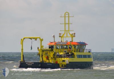
MERWESTROOM
Law Enforcement
Current Trip
BUOY LAYING OPPS
| Time Travelled | 17 mins |
|---|---|
| Remaining Time | --- |
| Distance Travelled | 0.99 nm |
| Remaining Distance | --- |
| AVG Speed | 4.4 Knots |
| MAX Speed | 4.5 Knots |
| AVG Wind | 5 knots |
| MAX Wind | 5 knots |
| MIN Temp | 14.5°C / 58.1°F |
| MAX Temp | 14.6°C / 58.28°F |
| Draught | 1.8 m |
| Position Received | Now |
Current Position
| Longitude | --- |
|---|---|
| Latitude | --- |
| Status | Under way using engine |
| Speed | 4.6 Knots |
| Course | 99° |
| Area | North Sea |
| Station | T-AIS |
| Position Received | Now |
Information
The current position of MERWESTROOM is in North Sea with coordinates 51.70846° / 4.48235° as reported on 2025-03-27 16:13 by AIS to our vessel tracker app. The vessel's current speed is 4.6 Knots
The vessel MERWESTROOM (IMO: 9840192, MMSI: 244170843) is a Law Enforcement It's sailing under the flag of [NL] Netherlands.
In this page you can find informations about the vessels current position, last detected port calls, and current voyage information. If the vessels is not in coverage by AIS you will find the latest position.
The current position of MERWESTROOM is detected by our AIS receivers and we are not responsible for the reliability of the data. The last position was recorded while the vessel was in Coverage by the Ais receivers of our vessel tracking app.
The current draught of MERWESTROOM as reported by AIS is 1.8 meters
Weather
| Temperature | 14.5°C / 58.1°F |
|---|---|
| Wind Speed | 5 knots |
| Direction | 239° WSW |
| Pressure | 1018.3 hPa |
| Humidity | 45 % |
| Cloud Coverage | 6 % |
Featured Company
Last Port Calls
| Port | Arrival | Departure | Time In Port |
|---|---|---|---|
| 2025-03-27 15:25 | 2025-03-27 15:57 | 32 m | |
| 2025-03-26 14:55 | 2025-03-27 12:18 | 21 h | |
| 2025-03-25 15:21 | 2025-03-26 07:36 | 16 h | |
| 2025-03-21 13:41 | 2025-03-24 10:37 | 2 d | |
| 2025-03-20 17:38 | 2025-03-21 07:20 | 13 h | |
| 2025-03-19 07:00 | 2025-03-19 07:47 | 46 m | |
| 2025-03-18 19:05 | 2025-03-19 06:42 | 11 h | |
| 2025-03-18 14:52 | 2025-03-18 15:43 | 51 m | |
| 2025-03-15 12:37 | 2025-03-18 07:25 | 2 d | |
| 2025-03-15 10:22 | 2025-03-15 10:47 | 24 m |
Most Visited Ports (Last year)
| Port | Arrivals | |
|---|---|---|
| 100 | ||
| 71 | ||
| 23 | ||
| 21 | ||
| 17 | ||
| 10 |
Last Trips
| Origin | Departure | Destination | Arrival | Distance | |
|---|---|---|---|---|---|
| 2025-03-27 13:18 | 2025-03-27 16:25 | 15.88 nm | |||
| 2025-03-26 08:36 | 2025-03-26 15:55 | 27.19 nm | |||
| 2025-03-24 11:37 | 2025-03-25 16:21 | 70.33 nm | |||
| 2025-03-21 08:20 | 2025-03-21 14:41 | 6.61 nm | |||
| 2025-03-19 08:47 | 2025-03-20 18:38 | 66.79 nm | |||
| 2025-03-19 07:42 | 2025-03-19 08:00 | 3.21 nm | |||
| 2025-03-18 16:43 | 2025-03-18 20:05 | 11.37 nm | |||
| 2025-03-18 08:25 | 2025-03-18 15:52 | 14.61 nm | |||
| 2025-03-15 11:47 | 2025-03-15 13:37 | 3.46 nm | |||
| 2025-03-15 07:46 | 2025-03-15 11:22 | 7.67 nm |
Events
| Time | Event | Details | Position / Dest | Info |
|---|---|---|---|---|
| 2025-03-27 15:57 | PORT DEPARTURE |
|
51.71254 / 4.45219
BUOY LAYING OPPS
|
Speed: 4.1 kn Course: 97° |
| 2025-03-27 15:30 | START Moving |
51.71892 / 4.41094
[NL] NUMANSDORP
|
Speed: 4.3 kn Course: 105° |
|
| 2025-03-27 15:28 | STOP Moving |
51.71951 / 4.40810
[NL] NUMANSDORP
|
Speed: 0.2 kn Course: 108° |
|
| 2025-03-27 15:25 | PORT ARRIVAL |
|
51.71919 / 4.40768
[NL] NUMANSDORP
|
Speed: 2.3 kn Course: 104° |
| 2025-03-27 14:07 | START Moving | 0.78 nm, East of DEN VENTJAGER |
51.72021 / 4.30149
BUOY LAYING OPPS
|
Speed: 3.1 kn Course: 77° |
| 2025-03-27 13:50 | STOP Moving | 0.63 nm, East of DEN VENTJAGER |
51.71972 / 4.29751
BUOY LAYING OPPS
|
Speed: 0.2 kn Course: 73° |
| 2025-03-27 13:37 | START Moving | 0.48 nm, North of DEN VENTJAGER |
51.72701 / 4.27675
BUOY LAYING OPPS
|
Speed: 3.1 kn Course: 167° |
| 2025-03-27 13:26 | STOP Moving | 0.4 nm, North East of DEN VENTJAGER |
51.72504 / 4.28621
BUOY LAYING OPPS
|
Speed: 0.3 kn Course: 301° |
| 2025-03-27 13:25 | START Moving | 0.43 nm, North East of DEN VENTJAGER |
51.72555 / 4.28624
BUOY LAYING OPPS
|
Speed: 3.1 kn Course: 157° |
| 2025-03-27 13:10 | STOP Moving | 0.59 nm, North of DEN VENTJAGER |
51.72914 / 4.27836
BUOY LAYING OPPS
|
Speed: 0.3 kn Course: 85° |