
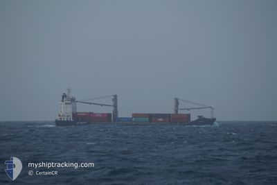
MARVEL
Container Ship
Current Trip
| Time Travelled | 4 h, 18 mins |
|---|---|
| Remaining Time | --- |
| Distance Travelled | 47.87 nm |
| Remaining Distance | --- |
| AVG Speed | 11.4 Knots |
| MAX Speed | 13.3 Knots |
| AVG Wind | 3.7 knots |
| MAX Wind | 5.8 knots |
| MIN Temp | 17.6°C / 63.68°F |
| MAX Temp | 19.8°C / 67.64°F |
| Draught | 7.4 m |
| Position Received | 1 m ago |
Current Position
| Longitude | 134.07999° |
|---|---|
| Latitude | 34.43702° |
| Status | Under way using engine |
| Speed | 10.9 Knots |
| Course | 98.9° |
| Area | Inland Sea |
| Station | T-AIS |
| Position Received | 1 m ago |
Info
Information
The current position of MARVEL is in Inland Sea with coordinates 34.43702° / 134.07999° as reported on 2024-05-06 06:08 by AIS to our vessel tracker app. The vessel's current speed is 10.9 Knots
The vessel MARVEL (IMO: 9296456, MMSI: 311655000) is a Container Ship that was built in 2004 ( 20 years old ). It's sailing under the flag of [BS] Bahamas.
In this page you can find informations about the vessels current position, last detected port calls, and current voyage information. If the vessels is not in coverage by AIS you will find the latest position.
The current position of MARVEL is detected by our AIS receivers and we are not responsible for the reliability of the data. The last position was recorded while the vessel was in Coverage by the Ais receivers of our vessel tracking app.
The current draught of MARVEL as reported by AIS is 7.4 meters
Weather
| Temperature | 17.9°C / 64.22°F |
|---|---|
| Wind Speed | 4 knots |
| Direction | 46° NE |
| Pressure | 1012.5 hPa |
| Humidity | 77.9 % |
| Cloud Coverage | 100 % |
Featured Company
Last Port Calls
| Port | Arrival | Departure | Time In Port |
|---|---|---|---|
| 2024-05-05 21:53 | 2024-05-06 01:52 | 3 h | |
| 2024-05-05 18:40 | 2024-05-05 21:44 | 3 h | |
| 2024-05-04 08:31 | 2024-05-04 17:26 | 8 h | |
| 2024-05-02 03:40 | 2024-05-02 05:16 | 1 h | |
| 2024-05-01 03:08 | 2024-05-01 06:44 | 3 h | |
| 2024-04-29 21:53 | 2024-04-30 02:32 | 4 h | |
| 2024-04-29 03:16 | 2024-04-29 07:56 | 4 h | |
| 2024-04-27 15:49 | 2024-04-28 03:08 | 11 h | |
| 2024-04-25 03:32 | 2024-04-25 05:56 | 2 h | |
| 2024-04-24 04:12 | 2024-04-24 09:00 | 4 h |
Most Visited Ports (Last year)
| Port | Arrivals | |
|---|---|---|
| 57 | ||
| 55 | ||
| 49 | ||
| 48 | ||
| 47 | ||
| 34 |
Last Trips
| Origin | Departure | Destination | Arrival | Distance | |
|---|---|---|---|---|---|
| 2024-05-06 06:44 | 2024-05-06 06:53 | 0.69 nm | |||
| 2024-05-05 02:26 | 2024-05-06 03:40 | 282.14 nm | |||
| 2024-05-02 14:16 | 2024-05-04 17:31 | 176.17 nm | |||
| 2024-05-01 15:44 | 2024-05-02 12:40 | 136.46 nm | |||
| 2024-04-30 11:32 | 2024-05-01 12:08 | 95.43 nm | |||
| 2024-04-29 16:56 | 2024-04-30 06:53 | 120.60 nm | |||
| 2024-04-28 12:08 | 2024-04-29 12:16 | 282.98 nm | |||
| 2024-04-25 14:56 | 2024-04-28 00:49 | 182.06 nm | |||
| 2024-04-24 18:00 | 2024-04-25 12:32 | 135.89 nm | |||
| 2024-04-23 11:51 | 2024-04-24 13:12 | 97.08 nm |
Events
| Time | Event | Details | Position / Dest | Info |
|---|---|---|---|---|
| 2024-05-06 05:59 | Status Changed | Under way using engine Default |
34.43572 / 134.04701
JP IYM A/S
|
Speed: 11.5 kn Course: 61° |
| 2024-05-06 05:44 | Status Changed | Default Under way using engine |
34.41745 / 133.99507
JP IYM A/S
|
Speed: 11.7 kn Course: 77.9° |
| 2024-05-06 05:33 | Status Changed | Under way using engine Default |
34.40957 / 133.95022
JP IYM A/S
|
Speed: 12.2 kn Course: 77° |
| 2024-05-06 05:16 | IN Coverage |
34.40957 / 133.95022
Inland Sea
JP IYM A/S
|
Speed: 11.9 kn Course: 77.6° |
|
| 2024-05-06 04:28 | Status Changed | Default Under way using engine |
34.31256 / 133.70779
JP IYM A/S
|
Speed: 11.9 kn Course: 61.5° |
| 2024-05-06 04:21 | Change Sea Area | Japanese part of the Inland Sea Japanese part of the Japan Sea |
34.29836 / 133.68164
Inland Sea
JP IYM A/S
|
Speed: 11.9 kn Course: 61.5° |
| 2024-05-06 04:21 | Status Changed | Under way using engine Default |
34.29836 / 133.68164
JP IYM A/S
|
Speed: 12 kn Course: 90° |
| 2024-05-06 04:21 | OUT of Coverage |
34.29836 / 133.68164
Inland Sea
JP IYM A/S
|
Speed: 11.9 kn Course: 61.5° |
|
| 2024-05-06 04:08 | IN Coverage |
34.29836 / 133.68164
Inland Sea
JP IYM A/S
|
Speed: 11.9 kn Course: 61.5° |
|
| 2024-05-06 01:52 | PORT DEPARTURE |
|
34.01380 / 133.52773
JP IYM A/S
|
Speed: 10 kn Course: 323° |