

MARGIRIS
Trawler
Current Trip
Current Position
| Longitude | --- |
|---|---|
| Latitude | --- |
| Status | Under way using engine |
| Speed | |
| Course | 210° |
| Area | North Sea |
| Station | T-AIS |
| Position Received | Now |
Information
The current position of MARGIRIS is in North Sea with coordinates 52.46155° / 4.58041° as reported on 2025-03-24 04:46 by AIS to our vessel tracker app. The vessel's current speed is 0 Knots and is currently inside the port of IJMUIDEN.
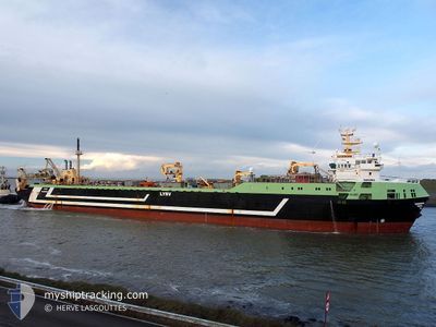
The vessel MARGIRIS (IMO: 8301187, MMSI: 277330000) is a Trawler that was built in 1985 ( 40 years old ). It's sailing under the flag of [LT] Lithuania.
In this page you can find informations about the vessels current position, last detected port calls, and current voyage information. If the vessels is not in coverage by AIS you will find the latest position.
The current position of MARGIRIS is detected by our AIS receivers and we are not responsible for the reliability of the data. The last position was recorded while the vessel was in Coverage by the Ais receivers of our vessel tracking app.
The current draught of MARGIRIS as reported by AIS is 7 meters
Weather
| Temperature | 7.9°C / 46.22°F |
|---|---|
| Wind Speed | 7 knots |
| Direction | 10° N |
| Pressure | 1011.1 hPa |
| Humidity | 95.7 % |
| Cloud Coverage | 100 % |
Featured Company
Last Port Calls
| Port | Arrival | Departure | Time In Port |
|---|---|---|---|
| 2025-03-22 12:42 | |||
| 2025-03-05 13:51 | 2025-03-06 00:16 | 10 h | |
| 2025-02-25 21:50 | 2025-03-04 16:46 | 6 d | |
| 2025-02-08 15:03 | 2025-02-08 22:53 | 7 h | |
| 2025-02-03 03:00 | 2025-02-07 20:31 | 4 d | |
| 2025-01-06 09:55 | 2025-01-15 14:33 | 9 d |
Most Visited Ports (Last year)
| Port | Arrivals | |
|---|---|---|
| 5 | ||
| 2 | ||
| 1 |
Last Trips
| Origin | Departure | Destination | Arrival | Distance | |
|---|---|---|---|---|---|
| 2025-03-06 00:16 | 2025-03-22 12:42 | 1630.87 nm | |||
| 2025-03-04 16:46 | 2025-03-05 13:51 | 236.27 nm | |||
| 2025-02-08 22:53 | 2025-02-25 21:50 | 1458.44 nm | |||
| 2025-02-07 20:31 | 2025-02-08 15:03 | 220.64 nm | |||
| 2025-01-15 14:33 | 2025-02-03 03:00 | 1033.55 nm |
Events
| Time | Event | Details | Position / Dest | Info |
|---|---|---|---|---|
| 2025-03-22 11:51 | STOP Moving |
52.46180 / 4.58029
[NL] IJMUIDEN
|
Speed: 0.3 kn Course: 205° |
|
| 2025-03-22 11:42 | PORT ARRIVAL |
|
52.46672 / 4.58415
[NL] IJMUIDEN
|
Speed: 4.4 kn Course: 152° |
| 2025-03-22 07:07 | Change Sea Area | Dutch part of the North Sea United Kingdom part of the North Sea |
52.70469 / 3.97605
North Sea
|
Speed: 7.4 kn Course: 151.3° |
| 2025-03-22 07:07 | IN Coverage |
52.70469 / 3.97605
North Sea
|
Speed: 7.4 kn Course: 151.3° |
|
| 2025-03-21 04:22 | OUT of Coverage |
55.68558 / .36399
North Sea
|
Speed: 10.7 kn Course: 158.1° |
|
| 2025-03-20 05:50 | Detected in Sea | United Kingdom part of the North Sea |
58.72782 / -3.38602
North Sea
|
Speed: 10.3 kn Course: 94.1° |
| 2025-03-20 03:59 | Draught Changed | 7 5.8 |
58.74170 / -4.00136
IJMUIDEN
|
Speed: 10.6 kn Course: 92.7° |
| 2025-03-20 03:53 | Destination Changed | IJMUIDEN FISHING GROUND |
58.74256 / -4.03653
IJMUIDEN
|
Speed: 10.7 kn Course: 93.4° |
| 2025-03-20 02:52 | Change Sea Area | United Kingdom part of the North Atlantic Ocean Irish part of the Celtic Sea |
58.74889 / -4.38314
North Atlantic Ocean
|
Speed: 10.8 kn Course: 91.8° |
| 2025-03-20 02:52 | IN Coverage |
58.74889 / -4.38314
North Atlantic Ocean
|
Speed: 10.8 kn Course: 91.8° |