
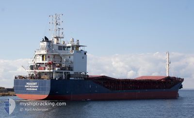
MALACHITE
General Cargo
Current Trip
| Time Travelled | 14 days |
|---|---|
| Remaining Time | --- |
| Distance Travelled | 242.87 nm |
| Remaining Distance | --- |
| AVG Speed | 6.8 Knots |
| MAX Speed | 8.8 Knots |
| AVG Wind | 12.2 knots |
| MAX Wind | 24.2 knots |
| MIN Temp | 11°C / 51.8°F |
| MAX Temp | 16.4°C / 61.52°F |
| Draught | 4.8 m |
| Position Received | 2024-04-05 22:26 |
Current Position
| Longitude | 29.99748° |
|---|---|
| Latitude | 41.36870° |
| Status | Under way using engine |
| Speed | 8.3 Knots |
| Course | 90.6° |
| Area | Black Sea |
| Station | T-AIS |
| Position Received | 2024-04-05 22:26 |
Info
Information
The current position of MALACHITE is in Black Sea with coordinates 41.36870° / 29.99748° as reported on 2024-04-05 22:26 by AIS to our vessel tracker app. The vessel's current speed is 8.3 Knots and is heading at the port of TEMRYUK.
The vessel MALACHITE (IMO: 9549645, MMSI: 273333650) is a General Cargo that was built in 2012 ( 12 years old ). It's sailing under the flag of [RU] Russia.
In this page you can find informations about the vessels current position, last detected port calls, and current voyage information. If the vessels is not in coverage by AIS you will find the latest position.
The current position of MALACHITE is detected by our AIS receivers and we are not responsible for the reliability of the data. The last position was recorded while the vessel was in Coverage by the Ais receivers of our vessel tracking app.
The current draught of MALACHITE as reported by AIS is 4.8 meters
Weather
| Temperature | 15.5°C / 59.9°F |
|---|---|
| Wind Speed | 9 knots |
| Direction | 11° N |
| Pressure | 1021.5 hPa |
| Humidity | 56.7 % |
| Cloud Coverage | 10 % |
Featured Company
Last Port Calls
| Port | Arrival | Departure | Time In Port |
|---|---|---|---|
| 2024-04-29 16:00 | 2024-05-03 15:36 | 3 d | |
| 2024-04-24 17:20 | 2024-04-27 07:54 | 2 d | |
| 2024-04-15 14:35 | 2024-04-19 13:55 | 3 d | |
| 2024-04-12 22:46 | |||
| 2024-04-01 23:16 | 2024-04-03 10:26 | 1 d | |
| 2024-03-09 11:58 | 2024-03-11 01:56 | 1 d | |
| 2024-03-08 08:13 |
Events
| Time | Event | Details | Position / Dest | Info |
|---|---|---|---|---|
| 2024-05-15 19:45 | STOP Moving | 14.2 nm, South of TAMAN |
44.89968 / 36.77101
RU TMR
|
Speed: 0.3 kn Course: 261° |
| 2024-05-15 11:47 | STOP Moving | 14.14 nm, South of TAMAN |
44.90047 / 36.77013
RU TMR
|
Speed: 0.2 kn Course: 198° |
| 2024-05-15 07:54 | STOP Moving | 14.18 nm, South of TAMAN |
44.89980 / 36.77011
RU TMR
|
Speed: 0.3 kn Course: 189° |
| 2024-05-13 18:09 | START Moving | 13.88 nm, South of TAMAN |
44.90179 / 36.75619
RU TMR
|
Speed: 38.6 kn Course: 297° |
| 2024-05-13 13:54 | STOP Moving | 14.31 nm, South of TAMAN |
44.89717 / 36.76890
RU TMR
|
Speed: 0.2 kn Course: 2° |
| 2024-05-13 13:48 | START Moving | 14.38 nm, South of TAMAN |
44.89674 / 36.77190
RU TMR
|
Speed: 4.8 kn Course: 354° |
| 2024-05-13 00:49 | STOP Moving | 14.32 nm, South of TAMAN |
44.89721 / 36.76963
RU TMR
|
Speed: 0.2 kn Course: 338° |
| 2024-05-12 09:11 | STOP Moving | 14.3 nm, South of TAMAN |
44.89716 / 36.76823
RU TMR
|
Speed: 0.1 kn Course: 30° |
| 2024-05-12 01:02 | STOP Moving | 14.28 nm, South of TAMAN |
44.89791 / 36.77002
RU TMR
|
Speed: 0.2 kn Course: 288° |
| 2024-05-11 13:59 | START Moving | 14.15 nm, South of TAMAN |
44.89468 / 36.74411
RU TMR
|
Speed: 47.5 kn Course: 262° |