
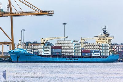
MAERSK ROUBAIX
General Cargo
Current Trip
| Time Travelled | 4 days |
|---|---|
| Remaining Time | --- |
| Distance Travelled | 951.41 nm |
| Remaining Distance | --- |
| AVG Speed | 9.7 Knots |
| MAX Speed | 14.2 Knots |
| AVG Wind | 7.7 knots |
| MAX Wind | 14 knots |
| MIN Temp | 16.5°C / 61.7°F |
| MAX Temp | 27°C / 80.6°F |
| Draught | 9.1 m |
| Position Received | 2025-08-17 13:56 |
Current Position
| Longitude | --- |
|---|---|
| Latitude | --- |
| Status | Under way using engine |
| Speed | 8.2 Knots |
| Course | 208.8° |
| Area | North Atlantic Ocean |
| Station | T-AIS |
| Position Received | 2025-08-17 13:56 |
Info
Information
The current position of MAERSK ROUBAIX is in North Atlantic Ocean with coordinates 23.87151° / -16.58710° as reported on 2025-08-17 13:56 by AIS to our vessel tracker app. The vessel's current speed is 8.2 Knots and is heading at the port of NASSIT.
The vessel MAERSK ROUBAIX (IMO: 9332688, MMSI: 477143100) is a General Cargo that was built in 2006 ( 19 years old ). It's sailing under the flag of [HK] Hong Kong.
In this page you can find informations about the vessels current position, last detected port calls, and current voyage information. If the vessels is not in coverage by AIS you will find the latest position.
The current position of MAERSK ROUBAIX is detected by our AIS receivers and we are not responsible for the reliability of the data. The last position was recorded while the vessel was in Coverage by the Ais receivers of our vessel tracking app.
The current draught of MAERSK ROUBAIX as reported by AIS is 9.1 meters
Weather
| Temperature | 16.9°C / 62.42°F |
|---|---|
| Wind Speed | 4 knots |
| Direction | 344° NNW |
| Pressure | 1010.8 hPa |
| Humidity | 94.7 % |
| Cloud Coverage | 80 % |
Featured Company
Last Port Calls
| Port | Arrival | Departure | Time In Port |
|---|---|---|---|
| 2025-12-06 12:00 | 2025-12-07 03:40 | 15 h | |
| 2025-12-01 04:37 | 2025-12-02 03:25 | 22 h | |
| 2025-11-16 05:11 | 2025-11-16 20:11 | 14 h | |
| 2025-11-12 00:39 | 2025-11-12 20:15 | 19 h | |
| 2025-11-04 05:00 | 2025-11-07 20:36 | 3 d | |
| 2025-10-21 10:28 | 2025-10-24 18:38 | 3 d |
Last Trips
| Origin | Departure | Destination | Arrival | Distance | |
|---|---|---|---|---|---|
| 2025-12-02 03:25 | 2025-12-06 12:00 | 1231.55 nm | |||
| 2025-11-16 20:11 | 2025-12-01 04:37 | 1934.73 nm | |||
| 2025-11-12 20:15 | 2025-11-16 05:11 | 957.19 nm | |||
| 2025-11-07 20:36 | 2025-11-12 00:39 | 1238.64 nm | |||
| 2025-10-24 18:38 | 2025-11-04 05:00 | 1317.32 nm | |||
| 2025-08-27 11:03 | 2025-10-21 10:28 | 985.58 nm |
Events
| Time | Event | Details | Position / Dest | Info |
|---|---|---|---|---|
| 2025-12-07 02:40 | PORT DEPARTURE |
|
-8.76444 / 13.27445
SLFNA
|
Speed: 6.2 kn Course: 40° |
| 2025-12-07 02:08 | START Moving |
-8.79719 / 13.25052
[AO] LUANDA
|
Speed: 3.5 kn Course: 359° |
|
| 2025-12-06 11:44 | STOP Moving |
-8.79752 / 13.25238
[AO] LUANDA
|
Speed: 0.3 kn Course: 240° |
|
| 2025-12-06 11:00 | PORT ARRIVAL |
|
-8.76687 / 13.26899
[AO] LUANDA
|
Speed: 3.8 kn Course: 221° |
| 2025-12-02 03:25 | START Moving | 0.37 nm, East of LOME |
6.13522 / 1.29267
SLFNA
|
Speed: 8.2 kn Course: 106° |
| 2025-12-02 03:25 | PORT DEPARTURE |
|
6.13522 / 1.29267
SLFNA
|
Speed: 2.7 kn Course: 115° |
| 2025-12-01 04:49 | STOP Moving |
6.14084 / 1.28474
[TG] LOME
|
Speed: 0.3 kn Course: 320° |
|
| 2025-12-01 04:37 | PORT ARRIVAL |
|
6.13547 / 1.29019
[TG] LOME
|
Speed: 5.4 kn Course: 275° |