
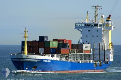
LUCIA
Container Ship
Current Trip
| Time Travelled | 10 days |
|---|---|
| Remaining Time | 4 h, 3 mins |
| Distance Travelled | 163.64 nm |
| Remaining Distance | 31.55 nm |
| AVG Speed | 7.2 Knots |
| MAX Speed | 8.2 Knots |
| AVG Wind | 13.2 knots |
| MAX Wind | 24.9 knots |
| MIN Temp | 21.4°C / 70.52°F |
| MAX Temp | 28°C / 82.4°F |
| Draught | 6.8 m |
| Position Received | Now |
Current Position
| Longitude | 54.71759° |
|---|---|
| Latitude | 25.43135° |
| Status | Under way using engine |
| Speed | 7.5 Knots |
| Course | 150.4° |
| Area | Persian Gulf |
| Station | T-AIS |
| Position Received | Now |
Info
Information
The current position of LUCIA is in Persian Gulf with coordinates 25.43135° / 54.71759° as reported on 2024-04-27 03:44 by AIS to our vessel tracker app. The vessel's current speed is 7.5 Knots and is heading at the port of JEBEL ALI. The estimated time of arrival as calculated by MyShipTracking vessel tracking app is 2024-04-27 07:47 LT
The vessel LUCIA (IMO: 9138343, MMSI: 341884000) is a Container Ship that was built in 1997 ( 27 years old ). It's sailing under the flag of [KN] St Kitts Nevis.
In this page you can find informations about the vessels current position, last detected port calls, and current voyage information. If the vessels is not in coverage by AIS you will find the latest position.
The current position of LUCIA is detected by our AIS receivers and we are not responsible for the reliability of the data. The last position was recorded while the vessel was in Coverage by the Ais receivers of our vessel tracking app.
The current draught of LUCIA as reported by AIS is 6.8 meters
Weather
| Temperature | 26.8°C / 80.24°F |
|---|---|
| Wind Speed | 6 knots |
| Direction | 19° NNE |
| Pressure | 1008.3 hPa |
| Humidity | 68.2 % |
| Cloud Coverage | --- |
Featured Company
Last Port Calls
| Port | Arrival | Departure | Time In Port |
|---|---|---|---|
| 2024-04-14 10:17 | 2024-04-16 08:08 | 1 d | |
| 2024-04-02 10:30 | 2024-04-04 01:02 | 1 d | |
| 2024-04-01 20:02 | 2024-04-02 04:35 | 8 h | |
| 2024-03-22 12:15 | 2024-03-25 00:18 | 2 d | |
| 2024-03-21 20:40 | 2024-03-22 07:11 | 10 h | |
| 2024-03-10 06:39 | 2024-03-11 12:02 | 1 d | |
| 2024-02-28 09:58 | 2024-03-01 18:57 | 2 d | |
| 2024-02-13 05:06 | 2024-02-14 13:20 | 1 d | |
| 2024-02-01 11:17 |
Most Visited Ports (Last year)
| Port | Arrivals | |
|---|---|---|
| 32 | ||
| 4 | ||
| 2 |
Last Trips
| Origin | Departure | Destination | Arrival | Distance | |
|---|---|---|---|---|---|
| 2024-04-04 05:02 | 2024-04-14 14:17 | 281.77 nm | |||
| 2024-04-02 08:35 | 2024-04-02 14:30 | 47.39 nm | |||
| 2024-03-25 04:18 | 2024-04-02 00:02 | 252.68 nm | |||
| 2024-03-22 11:11 | 2024-03-22 16:15 | 44.74 nm | |||
| 2024-03-11 16:02 | 2024-03-22 00:40 | 219.27 nm | |||
| 2024-03-01 22:57 | 2024-03-10 10:39 | 157.87 nm | |||
| 2024-02-14 17:20 | 2024-02-28 13:58 | 208.67 nm | |||
| 2024-02-01 15:17 | 2024-02-13 09:06 | 198.89 nm |
Events
| Time | Event | Details | Position / Dest | Info |
|---|---|---|---|---|
| 2024-04-27 01:23 | Change Sea Area | United Arab Emirates part of the Persian Gulf Iranian part of the Persian Gulf |
25.68563 / 54.55527
Persian Gulf
JEBEL ALI
|
Speed: 7.4 kn Course: 147.4° |
| 2024-04-26 23:01 | Destination Changed | JEBEL ALI SOHAR |
25.92510 / 54.39517
JEBEL ALI
|
Speed: 6.9 kn Course: 152° |
| 2024-04-26 23:01 | ETA Changed | 2024/04/27 10:00 2024/04/18 12:00 |
25.92510 / 54.39517
JEBEL ALI
|
Speed: 6.9 kn Course: 152° |
| 2024-04-26 22:37 | Change Sea Area | Iranian part of the Persian Gulf United Arab Emirates part of the Persian Gulf |
25.96559 / 54.37021
Persian Gulf
|
Speed: 7.3 kn Course: 149° |
| 2024-04-26 22:37 | IN Coverage |
25.96559 / 54.37021
Persian Gulf
|
Speed: 7.3 kn Course: 149° |