
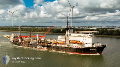
LORELAY
Pipe Layer
Current Trip
| Time Travelled | --- |
|---|---|
| Remaining Time | --- |
| Distance Travelled | 5356.11 nm |
| Remaining Distance | --- |
| AVG Speed | 9.4 Knots |
| MAX Speed | 13.7 Knots |
| AVG Wind | 15.6 knots |
| MAX Wind | 34.2 knots |
| MIN Temp | 10.4°C / 50.72°F |
| MAX Temp | 24.1°C / 75.38°F |
| Draught | 8.4 m |
| Position Received | 2 h, 27 m ago |
Current Position
| Longitude | -93.30042° |
|---|---|
| Latitude | 18.47582° |
| Status | Restricted manoeuverability |
| Speed | 0.5 Knots |
| Course | 86° |
| Area | Gulf of Mexico |
| Station | T-AIS |
| Position Received | 2 h, 27 m ago |
Info
Information
The current position of LORELAY is in Gulf of Mexico with coordinates 18.47582° / -93.30042° as reported on 2024-06-06 02:07 by AIS to our vessel tracker app. The vessel's current speed is 0.5 Knots
The vessel LORELAY (IMO: 7349807, MMSI: 249119000) is a Pipe Layer that was built in 1974 ( 50 years old ). It's sailing under the flag of [MT] Malta.
In this page you can find informations about the vessels current position, last detected port calls, and current voyage information. If the vessels is not in coverage by AIS you will find the latest position.
The current position of LORELAY is detected by our AIS receivers and we are not responsible for the reliability of the data. The last position was recorded while the vessel was in Coverage by the Ais receivers of our vessel tracking app.
The current draught of LORELAY as reported by AIS is 8.4 meters
Weather
| Temperature | 30.1°C / 86.18°F |
|---|---|
| Wind Speed | 14 knots |
| Direction | 34° NE |
| Pressure | 1004.6 hPa |
| Humidity | 77.7 % |
| Cloud Coverage | 12 % |
Featured Company
Last Port Calls
Most Visited Ports (Last year)
| Port | Arrivals | |
|---|---|---|
| 3 | ||
| 1 |
Last Trips
| Origin | Departure | Destination | Arrival | Distance |
|---|
Events
| Time | Event | Details | Position / Dest | Info |
|---|---|---|---|---|
| 2024-06-06 02:07 | OUT of Coverage |
18.47582 / -93.30042
Gulf of Mexico
OFFSHORE DOS BOCAS
|
Speed: 0.5 kn Course: 110.2° |
|
| 2024-06-06 02:07 | IN Coverage |
18.47582 / -93.30042
Gulf of Mexico
OFFSHORE DOS BOCAS
|
Speed: 0.5 kn Course: 110.2° |
|
| 2024-06-05 05:08 | OUT of Coverage |
18.66953 / -93.51926
Gulf of Mexico
OFFSHORE DOS BOCAS
|
Speed: 0.2 kn Course: 78.7° |
|
| 2024-06-05 04:08 | IN Coverage |
18.67046 / -93.52084
Gulf of Mexico
OFFSHORE DOS BOCAS
|
Speed: 0.1 kn Course: 127.1° |
|
| 2024-06-04 22:07 | OUT of Coverage |
18.67195 / -93.52232
Gulf of Mexico
OFFSHORE DOS BOCAS
|
Speed: 0.3 kn Course: 297.3° |
|
| 2024-06-04 19:47 | ETA Changed | 2024/07/04 01:00 2025/05/27 01:00 |
18.67287 / -93.52499
OFFSHORE DOS BOCAS
|
Speed: 0.3 kn Course: 300° |
| 2024-06-04 19:35 | IN Coverage |
18.67303 / -93.52527
Gulf of Mexico
|
Speed: Course: 301.1° |
|
| 2024-06-04 18:18 | OUT of Coverage |
18.67390 / -93.52679
Gulf of Mexico
|
Speed: 0.3 kn Course: 113.3° |
|
| 2024-06-04 18:13 | IN Coverage |
18.67394 / -93.52685
Gulf of Mexico
|
Speed: 0.2 kn Course: 134.8° |
|
| 2024-06-03 07:34 | OUT of Coverage |
18.45538 / -93.26595
Gulf of Mexico
|
Speed: 0.7 kn Course: 310.4° |