
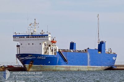
LIDER HALUK
Ro-Ro Cargo
Current Trip
LYMRA
| Time Travelled | 6 days |
|---|---|
| Remaining Time | --- |
| Distance Travelled | 773.34 nm |
| Remaining Distance | --- |
| AVG Speed | 9.3 Knots |
| MAX Speed | 11.3 Knots |
| AVG Wind | 7.8 knots |
| MAX Wind | 15 knots |
| MIN Temp | 12.5°C / 54.5°F |
| MAX Temp | 16°C / 60.8°F |
| Draught | 4.5 m |
| Position Received | 9 d ago |
Current Position
| Longitude | --- |
|---|---|
| Latitude | --- |
| Status | Under way using engine |
| Speed | 9.1 Knots |
| Course | 160.4° |
| Area | Adriatic Sea |
| Station | T-AIS |
| Position Received | 9 d ago |
Info
Information
The current position of LIDER HALUK is in Adriatic Sea with coordinates 40.05790° / 18.74895° as reported on 2025-02-07 10:38 by AIS to our vessel tracker app. The vessel's current speed is 9.1 Knots
The vessel LIDER HALUK (IMO: 8404276, MMSI: 371685000) is a Ro-Ro Cargo that was built in 1985 ( 40 years old ). It's sailing under the flag of [PA] Panama.
In this page you can find informations about the vessels current position, last detected port calls, and current voyage information. If the vessels is not in coverage by AIS you will find the latest position.
The current position of LIDER HALUK is detected by our AIS receivers and we are not responsible for the reliability of the data. The last position was recorded while the vessel was in Coverage by the Ais receivers of our vessel tracking app.
The current draught of LIDER HALUK as reported by AIS is 4.5 meters
Weather
| Temperature | 16°C / 60.8°F |
|---|---|
| Wind Speed | 13 knots |
| Direction | 175° S |
| Pressure | 1016.9 hPa |
| Humidity | 58.6 % |
| Cloud Coverage | 3 % |
Featured Company
Last Port Calls
| Port | Arrival | Departure | Time In Port |
|---|---|---|---|
| 2025-02-09 21:26 | 2025-02-10 21:10 | 23 h | |
| 2025-01-23 13:25 | 2025-02-05 15:58 | 13 d | |
| 2025-01-13 18:03 | 2025-01-15 11:41 | 1 d | |
| 2025-01-09 08:54 | 2025-01-09 18:48 | 9 h | |
| 2025-01-05 17:53 | 2025-01-07 19:59 | 2 d | |
| 2025-01-03 05:11 | 2025-01-03 20:13 | 15 h | |
| 2024-12-27 12:52 | 2024-12-29 19:11 | 2 d | |
| 2024-12-23 06:18 | 2024-12-23 21:23 | 15 h | |
| 2024-12-21 21:24 |
Most Visited Ports (Last year)
| Port | Arrivals | |
|---|---|---|
| 12 | ||
| 7 | ||
| 6 | ||
| 5 | ||
| 5 | ||
| 4 |
Last Trips
| Origin | Departure | Destination | Arrival | Distance | |
|---|---|---|---|---|---|
| 2025-02-05 16:58 | 2025-02-09 23:26 | 928.45 nm | |||
| 2025-01-15 13:41 | 2025-01-23 14:25 | 1085.76 nm | |||
| 2025-01-09 19:48 | 2025-01-13 20:03 | 768.25 nm | |||
| 2025-01-07 20:59 | 2025-01-09 09:54 | 352.53 nm | |||
| 2025-01-03 21:13 | 2025-01-05 18:53 | 351.00 nm | |||
| 2024-12-29 21:11 | 2025-01-03 06:11 | 919.81 nm | |||
| 2024-12-23 22:23 | 2024-12-27 14:52 | 802.92 nm | |||
| 2024-12-21 22:24 | 2024-12-23 07:18 | 247.28 nm |
Events
| Time | Event | Details | Position / Dest | Info |
|---|---|---|---|---|
| 2025-02-14 08:47 | STOP Moving | 6.43 nm, North West of EL DEKHEILA |
31.23303 / 29.73205
LYMRA
|
Speed: 0.2 kn Course: 35° |
| 2025-02-10 21:10 | PORT DEPARTURE |
|
32.38617 / 15.25205
LYMRA
|
Speed: 6.2 kn Course: 74° |
| 2025-02-10 20:57 | START Moving |
32.37100 / 15.22105
[LY] MISURATA
|
Speed: 6.2 kn Course: 74° |
|
| 2025-02-09 22:24 | STOP Moving |
32.36222 / 15.21467
[LY] MISURATA
|
Speed: 0.2 kn Course: 1° |
|
| 2025-02-09 21:26 | PORT ARRIVAL |
|
32.37212 / 15.22587
[LY] MISURATA
|
Speed: 4.8 kn Course: 275° |
| 2025-02-09 20:50 | START Moving | 2.73 nm, North East of MISURATA |
32.37952 / 15.28462
LYMRA
|
Speed: 5.9 kn Course: 255° |
| 2025-02-09 14:44 | STOP Moving | 3.09 nm, North East of MISURATA |
32.38022 / 15.29210
LYMRA
|
Speed: 0.1 kn Course: 48° |
| 2025-02-07 10:45 | Status Changed | Default Under way using engine |
40.04095 / 18.75608
LYMRA
|
Speed: 9.1 kn Course: 160.4° |
| 2025-02-07 10:38 | Status Changed | Under way using engine Default |
40.05790 / 18.74895
LYMRA
|
Speed: 9.4 kn Course: 162° |
| 2025-02-07 10:38 | OUT of Coverage |
40.05790 / 18.74895
Adriatic Sea
LYMRA
|
Speed: 9.1 kn Course: 160.4° |